dakhleh report 2000
TRANSCRIPT
7/27/2019 Dakhleh Report 2000
http://slidepdf.com/reader/full/dakhleh-report-2000 1/22
DAKHLEH OASIS PROJECT
SCA Report: 1999/2000 Season.
1.
REPORT PRESENTED TO THE SUPREME COUNCIL OF ANTIQUITIES, EGYPT, ON THE
2000 SEASON OF THE DAKHLEH OASIS PROJECT.
INTRODUCTION.
The 1999-2000 field season of the Dakhleh Oasis Project began on 16 November, 1999, when the field camp was opened
at Ezbet Bashendi in our usual quarters. A total of 58 project members joined the camp from time to time, with less than
30 at any one time. Three SCA representatives, one for Coptic and Islamic and two for Pharaonic and Roman antiquities,
accompanied the project this season.
Our field work encompassed most of our interests and included the linguistic study of the dialect at Bashendi,
physical anthropological studies of the remains from Ismant el-Kharab, excavations at Holocene Neolithic campsites, at
the Old Kingdom sites at Ein el-Gezareen, and the eastern Look-out posts, at the Roman village of Ismant el-Kharab
(Kellis). There was also surveying by the Pleistocene archaeologist, by the geologists and the archaeozoologist, both in
Dakhleh Oasis and in Kharga Oasis. The epigraphic survey of Deir el-Hagar temple continued until the end of the seasonin mid-March, 2000. The various team members have reported to me and I hereby pass on their accounts.
ENVIRONMENTAL STUDIES.
1. Geological Studies
The Geological Division of the Dakhleh Oasis Project sponsored two geologists in the field this season:
Prof. Robert Giegengack, Department of Earth and Environmental Science, University of Pennsylvania,and Jennifer R.
Smith, Ph.D. candidate in the same department.
The team was in the field from February 29 until March 14 and brought a Differential Global Positioning Satellite
System (DGPS) to enable them to acquire better topographic control of mapped points than had been possible in years
past. Our first objective was to establish elevations for the Pleistocene sediments mapped in the basin of Lake Balat by
Jacqueline Frizano in 1995 and 1996. We need to establish whether sedimentary units Frizano defined in the western basin
of Lake Balat are at the same elevations as the presumed equivalent sediments she mapped in the eastern basin, which
extends to beyond Tineida, and whether Quaternary carbonate sediments we mapped along the crest of the Balat anticline
are higher than the units mapped as CSS in the two basins. We occupied a number of outcrops in both basins, and along
the crest of the anticline, while our base station, established on the roof of the new DOP laboratory in Mut, recorded small
variations in the position calculated for that base station. When data are reduced we should be able to tell, with more
confidence than we have had heretofore, whether or not the two basins of Lake Balat were ever joined, and whether the
carbonate sediments along the crest of the Balat anticline simply represent another extension of the css or record an earlier
breakout of ground water as the Mut aquiclude was thinned by erosion along the crest of the anticline. If the latter, then
the anticline-crest carbonate sediments may represent the basal sediments of a lake that pre-dated Lake Balat, and of which
those sediments are the only rcord.
Preliminary reduction of DGPS data indicate that all CSS remnants are at the same elevation,
within 1 meter, but that the antcline-crest carbonate deposits are of the order of 10 meters higher.We returned to Bulaq, in Kharga Oasis, on March 3, to revisit the travertine deposits at Wadi
Midauwara and to map the deposit we identified in 1999 at Naqb Rizeikat (eventually we also remapped
the travertine deposits at Naqb Mata’ana; both Rizeikat and Mata’ana had been visited briefly by Caton-
Thompson and Gardner in the 1930's). On March 3 we took prehistorians Kleindienst and MacDonald to
Midauwara to examine several of the sites we identified last year. On March 4 we began searching for
7/27/2019 Dakhleh Report 2000
http://slidepdf.com/reader/full/dakhleh-report-2000 2/22
DAKHLEH OASIS PROJECT
SCA Report: 1999/2000 Season.
2.
routes whereby we could reach Rizeikat and Mata’ana by car, and from the 5th through the 11th of March
we mapped those travertine deposits. Neither is as complex stratigraphically as Midauwara, and neither
yielded as many potential prehistoric sites. Rizeikat is a massive outlier of plateau tufa, cut off from theedge of the escarpment by headward growth of two major wadis, and preserved as a consequence from
erosional removal by streams draining the edge of the escarpment. Rizeikat preserves evidence of massive
slumping as support of the plateau tufa was removed by undercutting of the base of the plateau remnant.
Several of the slump features appear to be earthflow lobes developed at the base of toreva blocks, a mass-
wasting phenomenon typical of watered soils.
We established reconnaissance Quaternary stratigraphic sections for Rizeikat and Mata’ana, and
sampled the major stratigraphic units for U-series age determination.
On March 12 we returned to Umm El Dabadib to try another method for acquiring cores from
several of the giant acacia trees that survive there, but we succeeded only in burning out the heavy-duty
battery-powered drill we had brought there at considerable expense. We will use the same dill bit next
year, but will undertake to power it with a standard electric drill driven off an AC generator.
Jennifer Smith has acquired enough field information to complete her Ph.D. thesis, which we hope
will be supported by U-series ages she will measure in the laboratory of Henry Schwarcz next summer.
2. Archaeozoology & Palaeontology.
Introduction.
Prof. C.S. Churcher spent from 26 January until 23 February in the Oasis, occupied in field and
laboratory work. The field work involved Late Cretaceous, Mid-Pleistocene and Holocene stratigraphy and
the collecting of vertebrate materials from strata or deposits of these ages. The stratigraphic geology of the
Libyan Escarpment, comprising the Taref, Mut, Duwi, Dakhla and Tarawan Formations, and of an
anomalous structure east of Teneida in the first four formations, was assessed. Occurrances of Dakhleh
Glass on the CSS plateau east of Camel Thorn Basin, were visited. CSS deposits southeast of Dakhleh’s
‘Eastern Gates’ were further investigated and consequently Palaeolake Teneida was extended to the
southeast, perhaps as far as the far hills. Laboratory work involved identifying animal materials from theRomano-Byzantine town of Kellis (Ismant el-Kharab), the Old Kingdom habitation site of Ein el-Gezareen,
and the conservation and identification of Holocene specimens, mainly from the Neolithic Sheikh Muftah
Cultural Unit. A hyæna den was partially excavated. Prof. Churcher, from time to time, was accompanied
and assisted by B. Churcher, N. Churcher, Prof. M. R. Kleindienst and H. Thurston.
Archeozoology.
I. Ein el-Gezareen (32/390-K2-2); An Old Kingdom Site: Archaeofaunal Samples.
The 1999 and 2000 samples derived from many squares but mainly from ‘Surface’ collections or
shallow levels (<25 cm). Thus contamination with modern items was always a possibly (eg., ass, pig or
chicken). The vertebrate materials recovered by A. J. Mills’ team at Ein el-Gezareen during field seasons
in the years 1998, 1999 and 2000 yeilded the expected major complex of animals: cattle (cow, Bos taurus),
goat (Capra hircus), and Dorcas gazelle (Gazella dorcas), with occasional representatives of other taxa.
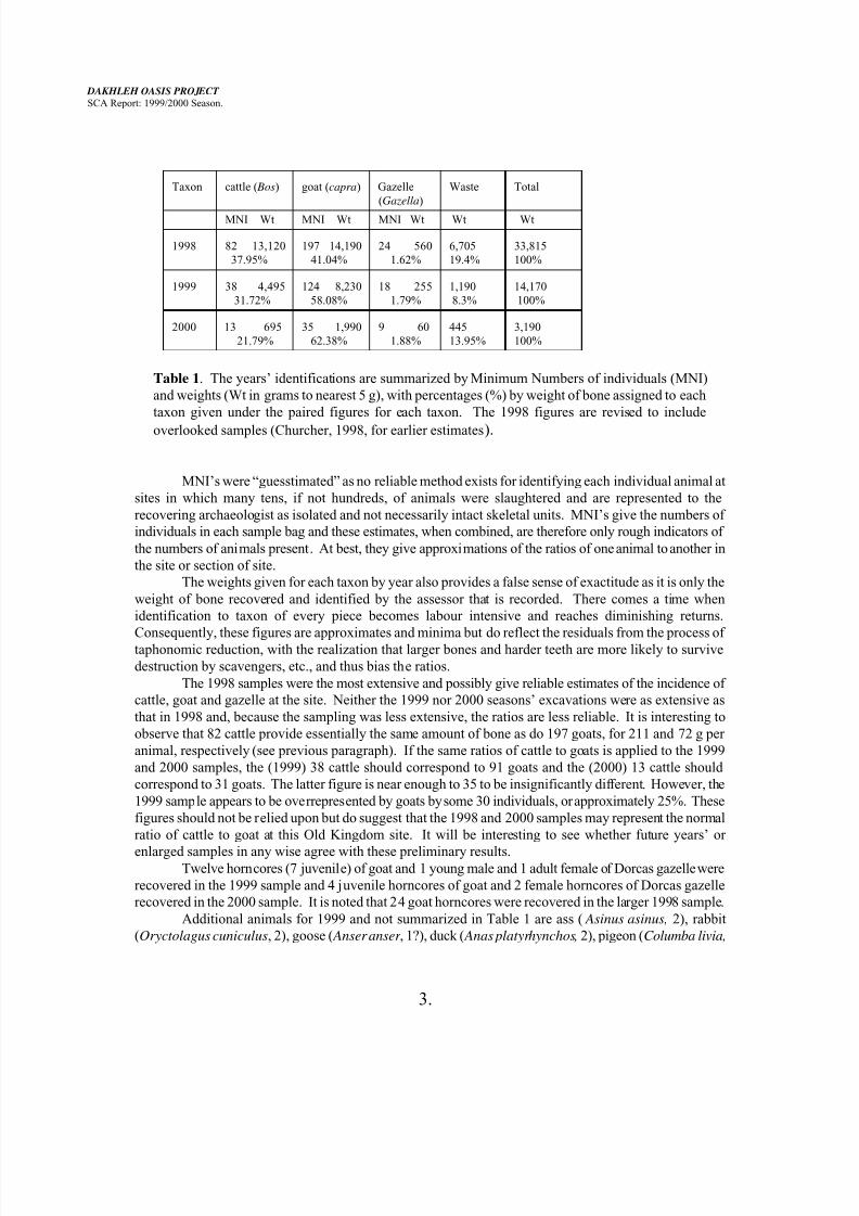
Taxon cattle ( Bos) goat (capra) Gazelle
(Gazella)
Waste Total
7/27/2019 Dakhleh Report 2000
http://slidepdf.com/reader/full/dakhleh-report-2000 3/22
DAKHLEH OASIS PROJECT
SCA Report: 1999/2000 Season.
3.
Taxon cattle ( Bos) goat (capra) Gazelle
(Gazella)
Waste Total
MNI Wt MNI Wt MNI Wt Wt Wt
1998 82 13,120
37.95%
197 14,190
41.04%
24 560
1.62%
6,705
19.4%
33,815
100%
1999 38 4,495
31.72%
124 8,230
58.08%
18 255
1.79%
1,190
8.3%
14,170
100%
2000 13 695
21.79%
35 1,990
62.38%
9 60
1.88%
445
13.95%
3,190
100%
Table 1. The years’ identifications are summarized by Minimum Numbers of individuals (MNI)
and weights (Wt in grams to nearest 5 g), with percentages (%) by weight of bone assigned to each
taxon given under the paired figures for each taxon. The 1998 figures are revised to include
overlooked samples (Churcher, 1998, for earlier estimates).
MNI’s were “guesstimated” as no reliable method exists for identifying each individual animal at
sites in which many tens, if not hundreds, of animals were slaughtered and are represented to the
recovering archaeologist as isolated and not necessarily intact skeletal units. MNI’s give the numbers of
individuals in each sample bag and these estimates, when combined, are therefore only rough indicators of
the numbers of animals present. At best, they give approximations of the ratios of one animal to another in
the site or section of site.
The weights given for each taxon by year also provides a false sense of exactitude as it is only the
weight of bone recovered and identified by the assessor that is recorded. There comes a time when
identification to taxon of every piece becomes labour intensive and reaches diminishing returns.
Consequently, these figures are approximates and minima but do reflect the residuals from the process oftaphonomic reduction, with the realization that larger bones and harder teeth are more likely to survive
destruction by scavengers, etc., and thus bias the ratios.
The 1998 samples were the most extensive and possibly give reliable estimates of the incidence of
cattle, goat and gazelle at the site. Neither the 1999 nor 2000 seasons’ excavations were as extensive as
that in 1998 and, because the sampling was less extensive, the ratios are less reliable. It is interesting to
observe that 82 cattle provide essentially the same amount of bone as do 197 goats, for 211 and 72 g per
animal, respectively (see previous paragraph). If the same ratios of cattle to goats is applied to the 1999
and 2000 samples, the (1999) 38 cattle should correspond to 91 goats and the (2000) 13 cattle should
correspond to 31 goats. The latter figure is near enough to 35 to be insignificantly different. However, the
1999 sample appears to be overrepresented by goats by some 30 individuals, or approximately 25%. These
figures should not be relied upon but do suggest that the 1998 and 2000 samples may represent the normal
ratio of cattle to goat at this Old Kingdom site. It will be interesting to see whether future years’ or
enlarged samples in any wise agree with these preliminary results.Twelve horncores (7 juvenile) of goat and 1 young male and 1 adult female of Dorcas gazelle were
recovered in the 1999 sample and 4 juvenile horncores of goat and 2 female horncores of Dorcas gazelle
recovered in the 2000 sample. It is noted that 24 goat horncores were recovered in the larger 1998 sample.
Additional animals for 1999 and not summarized in Table 1 are ass ( Asinus asinus, 2), rabbit
(Oryctolagus cuniculus, 2), goose ( Anser anser , 1?), duck ( Anas platyrhynchos, 2), pigeon (Columba livia,
7/27/2019 Dakhleh Report 2000
http://slidepdf.com/reader/full/dakhleh-report-2000 4/22
DAKHLEH OASIS PROJECT
SCA Report: 1999/2000 Season.
4.
5): wild animals, in addition to Dorcas gazelle, are desert fox (Fennecus zerda, 1), ostrich (Struthio
camelus, 1?, & 10 occurrances of egg shell), turret snail ( Melanoides tuberculatus, 2), Nile oyster ( Etheria
elliptica, 3 fragments), and Nile catfish (Clarias sp., spine and 7 vertebrae). Small birds and mice weresparcely present.
Additional animals from the 2000 sample are ass (4), rabbit (1), duck (1?), ostrich (3 occurrances
of egg shell), turret snail (6), apple snail (Pila ovata, 4), Nile oyster (1). Small birds, possibly including
pigeon, and mice were also present.
Six awls were recovered from within the 1999 bone sample and 10 awls and a bone knife in the
2000 sample. (Cf. >50 awls in the 1998 sample). Many fine pointed awls were recovered in all three
annual samples but no robust bone awls or fids mounted in gazelle or goat longbone halves were found in
the 1999 and 2000 samples. Perhaps this reflects the lack of deep excavations in these seasons.
Butchering techniques showed occasional uses of saws to detach horns or horncores, or to remove
the finer cancellous bone from the ends of dense longbone shafts. Axes were used to divide vertebral
columns axially, and mauls to reduce skeletons or expose marrow cavities, presumably after the meat had
been stripped from the bones. Some dense longbone pieces appear to have been prepared as ‘blanks’ for
further working. The catfish vertebrae in the 1999 sample were from the fish’s body cavity and still retain
their lateral processes. This shows that the fishes were whole and unfilleted, but probably gutted, when
processed for trade to the oasis.
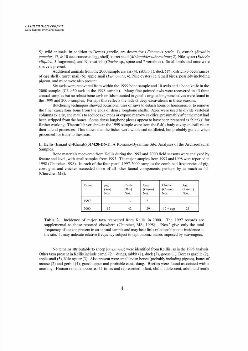
II. Kellis (Ismant el-Kharab)(31/420-D6-1); A Romano-Byzantine Site: Analyses of the Archaeofaunal
Samples.
Bone materials recovered from Kellis during the 1997 and 2000 field seasons were analyzed by
feature and level, with small samples from 1993. The major samples from 1997 and 1998 were reported in
1998 (Churcher 1998). In each of the four years’ 1997-2000 samples the combined frequencies of pig,
cow, goat and chicken exceeded those of all other faunal components, perhaps by as much as 4:1
(Churcher, MS).
Taxon pig(Sus)
Nos.
Cattle( Bos)
Nos.
Goat(Capra)
Nos.
Chicken(Gallus)
Nos.
Ass( Asinus)
Nos.
1997 3 2
2000 12 42 29 17 + egg 25
Table 2. Incidence of major taxa recovered from Kellis in 2000. The 1997 records are
supplemental to those reported elsewhere (Churcher, MS; 1998). ‘Nos.’ give only the total
frequency of a taxon present in an annual sample and may bear little relationship to its incidence at
the site. It may indicate relative frequency subject to taphonomic biases imposed by scavengers.
No remains attributable to sheep (Ovis aries) were identified from Kelllis, as in the 1998 analysis.
Other taxa present in Kellis include camel (2 + dung), rabbit (1), duck (3), goose (1), Dorcas gazelle (2),
apple snail (5), Nile oyster (3). Also present were small avian bones (probably including pigeon), bones of
mouse (2) and gerbil (4), grasshopper and probable canid dung. Beetles were found associated with a
mummy. Human remains occurred 11 times and represented infant, child, adolescent, adult and senile
7/27/2019 Dakhleh Report 2000
http://slidepdf.com/reader/full/dakhleh-report-2000 5/22
DAKHLEH OASIS PROJECT
SCA Report: 1999/2000 Season.
5.
individuals.
The first four animals (pig, cow, goat and chicken) represent 63% (100/158) of the incidences
compared to 80% in sites excavated in 1995-1998 (Churcher MS). This 17% difference may reflect in partthe increased incidence of ass (16% [25/158] from 5% [36/685]).
Six additional identifications of Nile oyster were made on materials collected in 1993 from Rooms 3,4,
6,24 & 27a, and Zone XVIII, Chamber C.
The identified specimens from Ein el-Gezareen and Kellis, unless retained for future reference or
because of modification as tools, were returned to their respective sites.
III. Holocene (Neolithic) Sites: Analyses of Archaeofaunal Samples.
The Holocene faunal specimens comprise those collected by McDonald from her excavations
during the field seasons of 1998, 1999 and 2000. They derive frm Locs. 105, 108A, 270B, 300, 385B,
387, and 388. They mainly consisted of elements of Dorcas gazelle (gazella dorcas), hartebeeste
( Alcelaphus buselaphus), and a large cattlebeast (either cow Bos, or Cape buffalo, Syncerus?). The Holocene bone specimens were frequently more fragile and fragmentary, and required
considerable conservation attention before identification was practicable and storage safe. The interesting
and less common identifications included hyaena, probably striped hyaena ( Hyaena hyaena/H. striata,
Loc.387); an artiodactyl larger than Dorcas gazelle and smaller than hartebeeste (Loc.270B); this may be a
large gazelle, e.g., the rhim or Loder’s gazelle (Gazella leptoceros), or possibly an early domestic goat
(Capra hircus; early for Northeast Africa). However, all possible goat specimens derive frm surface
deposits or nearly so (Levels 1 or 1A) and McDonald and I are waiting the recovery of a certain goat
element from a deeper horizon before confirming its presence in the Sheikh Muftah Cultural horizons
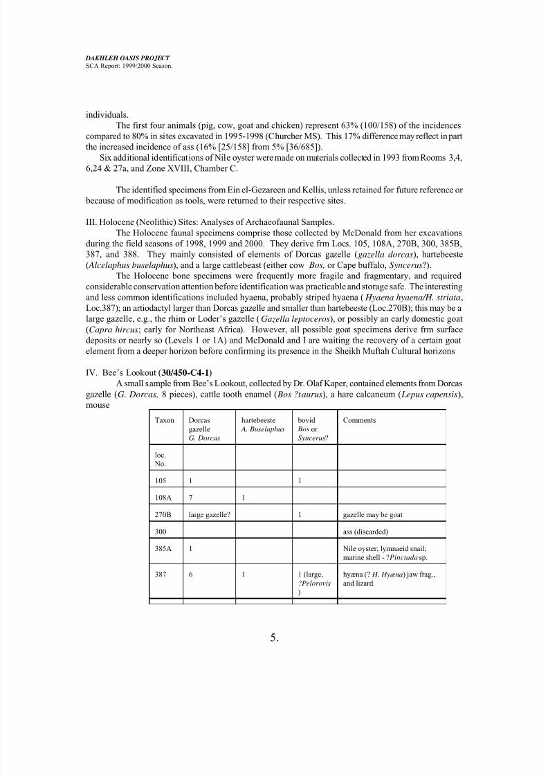
IV. Bee’s Lookout (30/450-C4-1)
A small sample from Bee’s Lookout, collected by Dr. Olaf Kaper, contained elements from Dorcas
gazelle (G. Dorcas, 8 pieces), cattle tooth enamel ( Bos ?taurus), a hare calcaneum ( Lepus capensis),
mouseTaxon Dorcas
gazelle
G. Dorcas
hartebeeste
A. Buselaphus
bovid
Bos or
Syncerus?
Comments
loc.
No.
105 1 1
108A 7 1
270B large gazelle? 1 gazelle may be goat
300 ass (discarded)
385A 1 Nile oyster; lymnaeid snail;
marine shell - ?Pinctada sp.
387 6 1 1 (large,
?Pelorovis
)
hyæna (? H. Hyæna) jaw frag.,
and lizard.
7/27/2019 Dakhleh Report 2000
http://slidepdf.com/reader/full/dakhleh-report-2000 6/22
DAKHLEH OASIS PROJECT
SCA Report: 1999/2000 Season.
6.
Taxon Dorcas
gazelle
G. Dorcas
hartebeeste
A. Buselaphus
bovid
Bos or
Syncerus?
Comments
388 1 1
Table 3. Animals identified from 7 Sheikh Muftah Cultural sites excavated in 1999 by Dr. M.M.A.
McDonald.
and gerbil bones, bird longbone shaft, snake bones (3 vertebrae with ris), a small scat containing a cricket
exoskeleton, possibly from a fennic fox (Fennicus zerda), and a leather strap, sized to encircle a wrist,
possibly made from goat hide, and possibly a wrist guard for a bowman. This site is dated to the Old
Kingdom on pottery and other artefacts, and the animals identified were extant in the region during this
period (and still are).
Vertebrate Palaeontology.
V. Holocene Palaeontology.
Additional vertebrate specimens were collected from pan sediments on the eastern margin of
Camelthorn Basin (Loc. 358), dated at 8000-6000 BP on their contiguity and stratigraphic equivalence
with Sheikh Muftah Cultural Unit clusters. These specimens derive from sediments below an unevenly
deflating duricrust that at present forms the main upper element of the pan deposits. Some specimens are
incorporated in the duricrust, which is calcareous and may be dissolved in dilute acetic acid to free the
bones or teeth. New specimens become exposed every 2 or 3 years as aeolian erosion thins or makes
windows through the crust into the underlying pan sediments. Specimens recovered this year include
associated bovid metacarpal, carpal and two proximal phalanges, on first examination indistinguishable
from Bos, both distal end of condyles and basioccipital of a skull, also similar to those of Bos, and anelbow (distal end of humerus and proximal ends of radius and ulna, in articulation) of Gazella dorcas. The
latter appears as though severed by a hyæna’s bite (see H. hyæna reported from Loc.387, above). These materials are coeval with the zebra jaw ( Equus capensis) and hartebeeste ( Alcelaphus
buselaphus) specimens recovered in 1998. Materials of similar age and geological provenance were
recovered by McDonald from Locs. 105, 108, and 108A this season. No visit to similar deposits of the
same age near Sheikh Muftah was possible this season.
VI. Mid-Pleistocene Palaeontology and Stratigraphy.
The mid-Pleistocene near-shore CSS exposures of Palaeolake Teneida, now topographically
elevated on crests of Taref Fm. sandstone yardang gebels on the eastern-southern margin of the oasis from
southeast of Ezbet Ein Hajir (Loc.348) to Iron Balls Spring (Loc.211) were scouted for further specimens
of the Iron Balls fauna. Loc.348 yeilded materials assignable to a large bovid, ?extinct giant African
buffalo Pelorovis, and include a damaged astragalus, an unfused proximal epiphysis of phalanx I of camel(?Camelus thomasi), postcranial materials of a gazelle similar to Gazella dorcas in size and morphology,
but larger, a scrap of an equid upper molar, and vertebral fragments, including zygapophyses from
vertebrae large enough to derive from Pelorovis and others from an animal apparently larger than the giant
buffalo but of unknown affinity (?hippo, rhino or elephant). The shaft of a bird bone was also recovered;
at present unidentified except to the size of a thrush. Loc.357 yeilded further scraps and a MSA/ESA flake
7/27/2019 Dakhleh Report 2000
http://slidepdf.com/reader/full/dakhleh-report-2000 7/22
DAKHLEH OASIS PROJECT
SCA Report: 1999/2000 Season.
7.
on a short visit.
I visited the CSS capped bedrock highs to the south of the Kharga road, near the old road camp,
before the gebels at the ‘Gates of the Oasis’. We observed that CSS extends to the crest and the east-westtrending Taref Fm. ridge that is the local topographical high and forms the limit of the oasis basin in the
area. From this crest it is possible to see the ‘Three Bashendi Ladies’, the ‘Cat and Two Kittens’ and the
‘Long Mountain’ gebels, some 10-20 km on the southheast horizon and to realize that there is nothing to
preclude Palaeolake Teneida from having extended well to the south of the present oasis and to have
flooded much of the area containing McDonald’s Holocene Neolithic sites. It will be necessary to visit
some of these distant gebels or those forming the eastern margin of this basin to search for ancient beach
cobbles or wave-cut benches.
VII. Cretaceous Palaeontology.
A. An additional sample of the layer that yeilded microfossils at Bee’s Friday Site (25o37.07'N;
29017.44'E) and a grab sample from Gerry’s Site east of Two Red Hills’ High Bluff (25
0 32.98'N: 29
0
18.87'E), from the layer that contained turtle and dyrosaur vertebrae, were obtained for collapsing in water
and sorting under magnification to expand the earlier sample and test that Gerry’s Site contained a fauna
similar to that at Bee’s Friday Site. The animals recognized at Gerry’s Site are all present in Bee’s Friday
Site although the depositional environment and size of fossil specimens reflect a higher energy
environment.
B. Dr. Peter Sheldrick located and collected parts of a mosasaur from the Dakhla Fm. east of the
Two Red Hills piedmont spur. These comprise six pectoral girdle and/or limb pieces and 10-15 vertebrae.
The former are in fair condition but the latter are badly wind eroded with the centra of the vertebrae almost
removed. An unsuccessful attempt was made to find this site. Subsequently, through correspondence with
Sheldrick, I believe that I have determined the locus and will visit it in the 2001 field season.
The bones appear to represent a left scapula (2 pieces), radius, ulna, partial metapodial or phalanx,
and an unidentified element of a smaller mosasaur, probably Cliastes sp. This is the first associated
vertebral column and girdle with limb elements so far found in the Dakhla Fm. shales. All previous
fragments have been isolated units or collections of vertebrae.C. During an excursion to the piedmont of the escarpment, north of Bashendi and near where
Sheldrick found mosasaur materials, for the purpose of checking the P-II and P-III crests of the piedmont
spurs for ESA/MSA tools, Kleindienst and I, and accompanied by others, located a shale horizon in the
Mut Fm. that contains dinosaur vertebrae and other bones. It also included a tooth of the shark
Scapanorhynchus rapax, chelonian vertebrae and two types of turtle carapaces. Seven vertebrae in various
states of preservation were collected and are stored for examination and conservation in 2001. Other
fragments, possibly of skulls or girdles, were also collected. The vertebrae are as yet unidentified but
provisionally represent a carnosaur, possibly Spinosaurus or Carcharodontosaurus, and other forms (not
crocodilian, and not the longostrine crocodilian Dyrosaurus. Further investigation of this stratum in 2001
should prove most fruitful!
Stratigraphy.IX. Cretaceous Stratigraphy (25
0 27.5'N, 29
023.20'E): Bow Wave Structure.
The anomalous ‘ring’ structure, dubbed the ‘Bow Wave Structure’, involving Taref Fm. sandstone,
Mut Fm. variegated shale and phosphorite sills, and Dakhla Fm. black shale (from outside to centre), that
lies northwest of Iron Balls Spring across the fault that separates the Taref Fm. sandstone gebels of Camel
Thorn Basin area from the chalk covered pediments to the north, was roughly mapped at a scale of 1:2000
7/27/2019 Dakhleh Report 2000
http://slidepdf.com/reader/full/dakhleh-report-2000 8/22
DAKHLEH OASIS PROJECT
SCA Report: 1999/2000 Season.
8.
based on the ærial photos of the area. The formations exposed were verified and keyed onto the sketch
map. Kleindienst measured dips, with recorded maxima of about 800 on an approximately E-W strike on
the Duwi Fm. phosphorites at the south-centre of the ‘ring’. Dips are less elsewhere around the ‘ring’ becoming markedly less to the east. The disarrangement of the strata to the northwest is further confused.
It is likely that the disarranged strata continue under the chalk mantled by P-III pediment that forms the
northern boundary of the exposed structure. The whole appears as though something ploughed into the
strata from the east at a relatively shallow angle, forcing strata downwards and creating a wave or berm of
up-ended strata on both sides and to the west or front, where the effect is most marked. Hence, like a bow
wave of something moving westwards. This conformation can be duplicated in sand with a fist!
Key fossils have been recovered from the Mut, Duwi and Dakhla that confirm that the ‘ring’
contains depressed portions of the strata that form the Libyan Escarpment. The Mut Fm. within the
structure yeilded a dinosaur (?carnosaur) vertebral centrum, a lungfish tooth plate (Ceratodus humei) and a
tooth of a shark (Scapanorhynchus rapax), all typical of Mut deposits. A block of displaced Mut and
Duwi Fms to the southeast of the structure yeilded a tooth crown of Sc. rapax from the Mut Fm. and parts
of two elasomosaur veterbrae from the Duwi Fm., the latter typical of the Duwi fauna. The exposures of
these strata units within the Bow Wave Structure should be carefully combed for further fossils to confirm
their identity and show that the units are typical and that the ring formation has been imposed upon the
units subsequent to their deposition.
There appears to be no sign of any penetration of the centre of the ‘basin’ formed by these up tilted
strata and thus, if the structure is indeed the result of an impact, the overlying rock that was displaced or
distorted to form shallower levels of the ‘ring’ has been eroded away. As no ring faults have yet been
discerned, the possibility that the structure represents a graben seems unlikely.
Miscellaneous
IX. Hyæna Den (Lat.250 28.06'N; Long 29
0 11.65'E).
An abandoned hyæna den was discovered in 1998 by Kleindienst and myself beneath the CSS cap
of a flat-topped gebel SE within the basin of Palaeolake Balat (Churcher, 1998, Field Report). Part of a
day was spent excavating one entrance (of two). The den had been vandalized by tomb robbers whomistook it for a Roman Period tomb. In 1998 bones were seen scattered about the entrance and down the
talus slope below, and represented ass, cow, goat, camel and hare, as well as red fox or jackal and fennec,
the latter three probably representing denizens after the extirpation of the hyænas. Bone from an
undisturbed layer towards the side of the entrance represented cow and ass, but also included a fragment of
a dentary with part of the last lower molar of a hartebeeste. If possible, a radiocarbon date on this fragment
would give a date for coexistence of hyæna and hartebeeste. Such a date might be as recent as 1960, and
Osborne and Helmy (1980, 428) give a recent record for H. Hyæna at ‘Dakhla Oasis.’ Bones collected in
1998 and examined by A. J. Sutcliffe of the Natural History Museum, London, in March 1998, were
confirmed as broken by hyæna.
X. Summary.
The accomplishments of this season are: 1. Identification of the archaeofaunal elements fromKellis, Ein el-Gezareen and the specimens recovered by McDonald. 2. The collection of further competent
in situ Sheikh Muftah age Holocene specimens. 3. Realization that Palaeolake Teneida probably extended
southeast to a shoreline against the hills to the east of the extensive basin southeast of Teneida and to the
hills visible on the south-southeast horizon. 4. The discovery of a new dinosaurian deposit in the Mut Fm.
and 5. The start of formulating how the Bow Wave Structures anomaly east of Teneida may have formed
7/27/2019 Dakhleh Report 2000
http://slidepdf.com/reader/full/dakhleh-report-2000 9/22
DAKHLEH OASIS PROJECT
SCA Report: 1999/2000 Season.
9.
and its geological composition.
Scheduled for further investigation in 2001 is the bow wave Structure (checking the strata or
formations, and measuring the dips, strikes, etc, with GPS locations), the Mut Fm. new dinosaur locality,the Mid-Pleistocene Iron Balls Faunal horizon, and the southeastern shoreline of Palaeolake Teneida.
Stratigraphic, geomorphologic and palaeontological inquiries will be persued as opportunities become
available.
XI. References.
Churcher, C. S. , MS., Faunal remains from Kellis: animals identified from deposits within temples,
churches and domestic areas. [26 p., 1 table].
Churcher, C. S. 1998. Dakhleh Oasis Project. Report for the 1998 Field Season. [10 p]
Osborne, D. J. And I. Helmy. 1980. The Contemporary Mammals of Egypt (including Sinai). Fieldiana
(Zoology), N.S. No.5 (1309), 428p.
3. Archaeobotany.
This year’s field season of the archaeobotanists Ursula Thanheiser and Johannes Walter lasted four weeks.
During this period plant remains fom two Holocene sites, two Old Kingdom sites, and the Romano-
Byzantine village of Kellis were extracted.
A. Holocene Sites.
This year’s work concentrated on excavating two Sheikh Muftah Neolithic sites, but only one of these
yeilded archaeobotanical materials (Loc. #105 = 30/420-P1-1). A total of 9 soil samples were taken, the
charcoal and charred plant macro-remains extracted with the aid of an electrostatic device and analysed.
All samples yeilded some charcoal; albeit from one genus only: Tamarix sp. (Tamarisk). No marco-
remains were present on the sites. Whether this is due to differential preservation of the two classes of
material, or whether this reflects a specific use of the sites, is yet unclear.
B. Old Kingdom Sites.
1. Ein el-Gezareen (32/390-K2-2)
From a total of 15 soil samples which were left over from last year’s excavation, the charred plant
remains were extracted and analyzed. In contrast to the previous season, the amount of charred material
present in the soil samples was rather low. All samples yeilded emmer wheat (Triticum dicoccum) and
barley remains ( Hordeum vulgare) but hardly any other fruits or seeds. In addition to the macro-remains,
wood charcoal from tamarisk (Tamarix sp.) and Nile acacia ( Acacia nilotica) was found.
2. Watch Post 30/450-C4-1
Seven soil samples were taken and the plant remains extracted in the usual way. All samples
yeilded charcoal of both tamarisk (Tamarix sp.) and acacia ( Acaacia sp.), but no other plant remains. Thisleads to the tentative conclusion that the soldiers stationed on the post were supplied with food and did not
prepare their meals there.
3. The Romano-Byzantine settlement of Kellis (31/420-D6-1)
Work concentrated on the analysis of plant remains which were left over from previous seasons
7/27/2019 Dakhleh Report 2000
http://slidepdf.com/reader/full/dakhleh-report-2000 10/22
DAKHLEH OASIS PROJECT
SCA Report: 1999/2000 Season.
10.
and on samples from the newly excavated areas A/9, A/10, and C/2/2 - C/2/6. Currently we have a total of
c.850 samples from domestic areas, the temple complex and Large Eastern Church. The results of this
year’s work fit well into the pattern already emerging during previous seasons. Staple crops are breadwheat (Triticum aestivum) and hulled barley ( Hordeum vulgare), followed by hard wheat (T. durum) and
occasionally emmer wheat (T. diccocum) and pearl millet (Pennisetum americanum). Amongst the pulses,
fava bean (Vicia faba) is dominant. Other species (lentil - Lens esculenta and pea - Pisum sativum) are
very rare. This stands in strong contrast to other Roman sites (like Mons Claudianus) where pulses occur
in abundance. The spectrum of other plants (condiments and spices, fruits and nuts, fiber plants, weeds
and ruderals) was extended by a new plant, castor bean ( Rhicinus communis).
ARCHAEOLOGICAL STUDIES.
4. Pleistocene Archaeology & Geoarchaeology.
The Pleistocene archaeologist, Prof. M. R. Kleindienst, began her work on February 9th , departed on 8th
March, and was based at Ezbet Bashendi. From time to time, Prof. Kleindienst was accompanied and
assisted by Prof. C.S. Churcher, N. Churcher, B. Churcher, Prof. R.F. Giegengack, J.R. Smith and H.
Thurston. She reports as follows.
Limited field time meant limited objectives:
1) to verify, photograph & further explore the two “Dakhleh Glass” localities (Loc. 211, Loc.390),
2) to finally walk up the old Darb el-Tawil trail, known since 1986 from air photos and palaeontological
work below the escarpment,
3) to visit the area not yet surveyed in the Piedmont NE of Bashendi, east of locs. 318/319,
4) to obtain samples for Schwarcz for a new dating method, now under trial,
5) to liase with the geologists re their work at Kharga, mapping tufas at Wadi el-Medawarra in 1998 &
1999,6) to finish a small area of survey for MSA related to the CSS, SE of the Loc.211 terrace. (This was not
completed in 1998),
7) to process some old collections, from various localities.
Re: 1) I established the southward spread of Dakhleh Glass at loc.211, extending from the CSS-capped
jebels overlooking the eastern Camel Thorn Basin, to the southern detached CSS terrace remnant of Loc.
211. The northern extent has not yet been fully established; the eastern and western limits have probably
been eroded away. Dakhleh Glass resting on the Holocene pan sediments at loc.358, is clearly redeposited
as it is on the surface of el-Akoulah Pan. (At Loc.358, in Camel Thorn Basin, I found a ‘sinter’, formed by
the melting of the upper pan sediments, associated with a Holocene locality [?Sheikh Muftah Unit], a
material which is quite different from Dakhleh Glass.
a) With Churcher and others, and later with Giegengack and Smith, I investigated the ‘Bow
Wave Structure’ (BWS) north of el-Akoulah Basin, which was discovered in 1996. Its origin remainsa mystery that requires future geological investigations. It is clear that all the existing geological maps
of this entire area south of el-Battikh Promontory are incorrect regarding the geological formations
present, and the degree of faulting and cross-faulting. One possible origin for the BWS is that of an
impact crater, although Giegengack considers this unlikely. We also investigated the three areas of
displaced sediments (duwi and Dakhla Formations) noted in 1996, which are resting on the eroded
7/27/2019 Dakhleh Report 2000
http://slidepdf.com/reader/full/dakhleh-report-2000 11/22
DAKHLEH OASIS PROJECT
SCA Report: 1999/2000 Season.
11.
Tarif sandstone surface below the rim of el-Akoulah (? approximately = rim of Palaeolake Teneida).
We do not yet understand how small blobs of sediment came to be out of stratigrafic order well south
of the stratified bedrock exposures. b) I briefly visited Loc. 390 southwest of Balat. While photographing the CSS and Dakhleh
Glass deposits, I noted pieces of a curious iron-rich rock which appears to have a melted surface,
some as large as 60 cm in length. This may be a chondrite, and related to the Dakhleh Glass at Loc.
390, occurrance 2, which had been found in 1998. This needs confirmation by experts. I will map
and test Loc. 390 in 2001, where ESA appears to derive from the ‘old reg’ (aeolized veneer)
underlying the CSS.
Re: 2) With several others, I climbed the Darb el-Tawil trail that follows a C1 colluvial ramp up the
escarpment face, south of the Wadi el-Tawil. This shows clearly on air photographs, and is easily followed
although it is washed-out in places and probably has little modern usage. I collected ‘trail garbage’ which
C. Hope identified as ranging from Old Kingdom through modern; actually, the 2 sherds identified as
‘modern’ were the only ones seen. Mainly, the indicated usage of the trail in antiquity goes back to pre-
Old Kingdom times (Holocene lithic debris) up to Medieval Islamic times; for the latter there is a staging
area to the north of the trail head on the Plateau with abundant broken water jugs with their plugs, faience
plate fragments, etc. A local informant says that the trail is still known as “The Walking Trail”. However,
bones identified by Churcher indicate that both donkeys and camels ascended/descended in Antiquity. Just
below the trail head is a protected area behind large fallen limestone blocks, with slab structures. This may
be the ‘outlook site’ or ‘checkpoint’ for the trail, although no petroglyphs were noted in our rather hasty
passage. Some sherdage is associated (not collected). The French Mission may have previously collected
some sherdage, as this trail is marked on some of their published maps of Dakhleh - e.g. in BIFAO ‘99
(Marchand and Tallet 1999:316)
a) C. S. and N. Churcher found a ‘staging area’ site of Sheikh Muftah Unit/Pharaonic times
southeast of the trail head, in a long deflation basin lying to the east of a limestone yardang. Its age
and importance were later confirmed by a visit with McDonald and Taubner (Loc.402).
b) The basal remnants of tufa terraces were noted in place along the trail, about 1/3rd of the way up.These were later confirmed in a visit with Giegengack and Smith. This is the first find of tufa
terraces in place on the Dakhleh Escarpment face, although we have previously predicted that they
should exist.
c) The two later visits to the area allowed me to explore the P-II and P-III terraced surfaces below the
colluvial ramp, as well as for tufa outcrops and large displaced blocks in the colluvium and the terrace
gravels. It is noteworthy that while lithics of Holocene archaeological units form a continuous scatter
on the colluvial face, extending with lesser frequency onto the two terraced remnants, there are
practically NO Pleistocene lithics at all (only 3 Levallois flakes found). This area was little
frequented during the Pleistocene, which agrees with observations previously made in the Wadi el-
Tawil and in Wadi el-Ueb to the north. The northeast corner is clearly a ‘Transit zone’ for the
Pleistocene inhabitants of Dakhleh.
Re: 3) Two visits with Churcher established that the area east of Loc.318/319 deserves a detailed survey in2001. The area number assigned is Loc. 394. In the course of one visit, I noted a relatively rich
palaeontological site in the Mut Formation (the “Monday Site”), lying below a P-III terrace remnant.
Re: 4) Samples from Loc.318 do not appear to be suitable for Schwarcz’s new ‘skinflint’ dating technique.
If samples can be dated they would help to anchor the late Pleistocene sequence, because, based upon
7/27/2019 Dakhleh Report 2000
http://slidepdf.com/reader/full/dakhleh-report-2000 12/22
DAKHLEH OASIS PROJECT
SCA Report: 1999/2000 Season.
12.
condition, morphology and technology, Loc. 318 is younger that the Dakhleh Unit (Aterian), and older
than the Sheikh Mabruk Unit.
Re:5) A one-day survey with McDonald, Giegengack and Smith was made to Wadi el-Medauwarra,
Kharga Oasis, on March 3rd:
a) One locality (MD-2), fortunately sampled by Kleindienst and Wiseman in 1998, is now
destroyed by roadwork along the new Luxor tarmac road. The entire area of wadi fan gravels
observed by Churcher and Kleindienst in 1996 is now destroyed, both north and south of the new
road. Any archaeological information there is now lost. Small tufa terraces to the northwest, which
also bore archaeological material in 1996, have been severely damaged. (See report by McDonald,
below, for Holocene localities visited: MD-4, -5 ,-6).
b) Due to time constraints, it proved only possible to visit one Pleistocene locality, and MSA
workshop (MD-10), for about 10 minutes; this requires further survey in 2001, as it appears either to
be a pre-Aterian MSA unit which is already employing some ‘Aterian’ traits, or possibly it is an older
Aterian unit. The workshop area lies on an easy access route to the Plateau top, adjacent to tufa
terraces, with large chert nodules of excellent quality, some incorporated in large fallen limestone
blocks lying on a series of benches below the Plateau rim. Time did not permit relocation of the
Earlier Stone Age locality which the geologists had found during their mapping in 1999 (Smith et al,
1999).
c) The Pleistocene localities discovered by Giegengack and Smith are more difficult of access,
and are probably safe from tourist looting at present. However, the Holocene sites near the new road
embankment are endangered. These should be mapped and collected in 2001, or the evidence will
disappear.
d) A field register book for Kharga Oasis was initiated.
Re: 6) Survey of the southeastern edge of Loc.211 CSS terrace was completed. Sparse finds suggest that
the main MSA presence was further north, beginning with Loc. 391 and extending to Loc. 374, at the Iron
Balls Spring, and then further north to Loc. 361 nearer the northern shore of Palaeolake Teneida. Only onesmall fragment of bone was found. (Only a few MSA finds have been collected south of the Loc. 211
terrace in previous years. No artefacts were found associated with the CSS of the detached terrace remnant
[Loc. 211S], which would have been even further out into the palaeolake.)
a) Churcher and I also revisited Loc.349 (located in 1996), in order to obtain a GPS reading on
the southernmost CSS yardangs preserved on the sandstone ridge south of the Kharga road, and south
of Locs. 350-351-352. Elevations here are apparently over 155 m about sea level, and these small
remnants suggest that the palaeolake may have had a much larger southern extent that we previously
believed. A search will be made for ancient beach 1 levels to the east and south in 2000. Basal layers
of the yardanged southeastern-most CSS remnant appear to incorporate diatomite, which can give
valuable palaeoenvironmental information.
b) Giegengack suggests that the three palaeolake basins conservatively identified by Kleindienst
and Churcher in 1998 (Churcher et el, 1999) were once interconnected, at times forming one large
lake (ca. 30 x 30 km?). However, the larger one makes the lake, the more water one must put into the palaeobasin, and the greater the changes one must envisage for the mid-Pleistocene
palaeoenvironments of Dakhleh. This remains a probleme for the continuing geoarchaeological and
zooarchaeological investigations of the CSS.
Re: 7) Processing of various collections marked ‘TBP’ was completed. Others still remain undone, alas!
7/27/2019 Dakhleh Report 2000
http://slidepdf.com/reader/full/dakhleh-report-2000 13/22
DAKHLEH OASIS PROJECT
SCA Report: 1999/2000 Season.
13.
References cited:
Churcher, C.S.., M. R. Kleindienst and H.P. Schwarcz
1999. Faunal remains from a Middle pleistocene lacustrine marl in Dakhleh Oasis, Egypt :
palaeoenvironmental reconstructions. Palaeogeography, Palaeoclimatology, Palaeoecology 154
(4): 301- 312.
Marchand, S., and P. Tallet
1999. Ayn Asil et l’oasis de Dakhla au Nouvelle Empire. Bulletin de l’institut Francais
d’Archeologie Orientale 99:307-352.
Schwarcz, H.P., R. Szkudlarek, M. R. Kleindienst and N. Evenesen
n.d. Fire in the Desert: the occurrance of a high-Ca silicate glass near the Dakhleh Oasis, Egypt.
In The Oasis Papers II: The Second Dakhleh Oasis Project Research Seminar, Royal Ontario
Museum and Department of Anthropology, Toronto, June 16-20, 1997. M.F. Wiseman, ed.,
submitted Oxford, Oxbow Books.
Smith, J.R., R.F. Giegengack, and J.B. Smith
1999. Geoarchaeology of Quaternary tufa deposits at Wadi Miduwara, Western Desert, Egypt.
1999 Annual Meeting & Exposition, The Geological Society of America, Octobere 25-28, 1999.
Denver Colorado, 1999. Abstracts with Programs.
5. Holocene Prehistory.
The Holocene prehistorian, Dr. M. M. McDonald spent nearly 9 weeks in the field, starting January 7.
During most of that time she was assisted by Ines Teubner, a student from Alexander Humboldt Universityin Berlin. While a few days were spent on survey in the eastern part of the oasis, atop the eastern Plateau,
and in Kharga Oasis, most field time was devoted to the excavation of several sites.
We did work on all 3 Late Prehistoric cultural units in Dakhleh, but concentrated on the Sheikh
Muftah. Sheikh Muftah is the latest of the units, overlapping the Old Kingdom occupation of the oasis, but
remains the most poorly understood. Sh. Muftah sites tend to occur near (or under) modern cultivation,
and while nearly 100 have been recorded in El-Dakhleh, few are known to retain in situ deposits, and
before January 2000, none had been excavated.
Loc.105 (30/420-P1-1) seemed an unusually promising site. It lies SW of the Balat cultivation, on
the edge of an extensive area of land crusted with salt and gypsum, in a spot that may have been a swamp
in the mid-Holocene. Here, worked stone, pottery, and considerable animal bone are eroding out of the
crust. We therefore established a grid 42 x 26 m over the richest part of the site, mapped at all at 1:100,
and then excavated a total of 65m2.
Deposits are differentially preserved, but in much of the excavated area, we detected 3 buriedlayers bearing cultural material : one right under the crust; below it a dark grey level with much charred
matter, up to 10 cm thick, and below that a thin light grey buff sandy silt, with artefacts and bone occurring
in the top 6 - 8 cm of the layer.
The goals in excavating are to recover organics - plant and animal remains - to shed light on
prehistoric diets and for dating purposes, as well as in situ artefacts, and information about the settlement
7/27/2019 Dakhleh Report 2000
http://slidepdf.com/reader/full/dakhleh-report-2000 14/22
DAKHLEH OASIS PROJECT
SCA Report: 1999/2000 Season.
14.
itself. At 105, we met some of these goals, and not others.
Concerning settlement information, we found no evidence of shelters at the site, but did encounter
3 hearths. Relatively little charcoal was recovered, despite the dark grey Layer 2 deposits, and none of ithas been analysed yet. A considerable amount of animal bone was collected, and so far gazelle and
hartebeeste have been identified. Both ground stone (slabs and handstones) and chipped stone are common
at Loc.105, and an estimated 2400 flakes were excavated. The collection of 105 tools includes 40 (mostly
stubby) points, as well as notches, denticulated and retouched pieces in nodular chert, and scrapers
fashioned in tabular chert. The pottery at 105 can be identified as ‘Late Sh. Muftah’ material.
Site 108 (30/435-B3-2) is another Sh. Muftah site associated with the crusted land, but much
smaller than 105. Here too, animal bone was eroding out within a larger scatter of pottery and chipped
stone. The pottery and lithics were collected within a 28 x 10 m grid, while 8 m2 were excavated to
recover animal bone from several species. A carnelian bead was recorded as well.
Aside from the Sh. Muftah, some work was done on the Bashendi cultural unit as well. Two new
Bashendi B sites, Loc 388 (31/420-N10-2) and Loc.389 (31/420-N10-3) were recorded in the vicinity of
Loc.105, and a collection of lithics and sherds was made at 388. Further southeast in the oasis, within the
large Bashendi site of 228, the ‘Mound Site’, or Loc.387, tested last year, had yeilded an extrordinarily rich
fauna, including a very large bovid and hyæna. To add to that collection I went back for a couple of days
and dug another 5 m2in an ashy pit, adjacent to the 5 m
2excavated last year.
Work on the Masara unit in Dakhleh Oasis this year was confined to site 265 (29/450-G3-2), a
Masara C hut circle site originally tested in 1997. That year, Hut 8, one of the 19 structures on the site,
was excavated. This year we tested 2 other structures and some of the deposit between the circles. Hut 1 is
a well-defined circle of standing slabs, about 3 m in diameter, within a cluster of 3 structures. In and
around Hut 1, 42 m2
were planned at 1:20. Within the hut 5 m2, its western half, was excavated. The
deposit was quite similar to that in Hut 8. The floor of the hut, 25 cm below the present surface, and 10 -
15 cm above bedrock, had been only slightly hollowed out when the hut was built. Two small hearths
consisting of ashy patches with charcoal, over fire-reddened soil, were found. One, near the hut centre,measured 65 cm across, the other, against the west wall, 30 cm across. Elsewhere the hut floor was
relatively clean yeilding scattered ostrich eggshell and charcoal, a couple of flakes, a large sandstone block
against the N wall and a few slabs that had fallen from the wall slabs, probably after the hut was
abandoned.
Outside of Hut 1, we excavated 5 m2 of the surface lying between Hut 1 and 2 of its neighbours.
This area proved clean, yeilding no features, and only a few chipped stones including a core and a couple
of stubby points. Elsewhere on the site, we excavated an isolated bin consisting of a circle of standing
slabs 1 m across, which proved empty.
While considerable work must have gone into the construction of the hut circles of 265, the
relative lack of chipped stone and other debris suggests the site could not have been occupied for very long.
Aside from the work on the oasis floor, we investigated a playa atop the plateau to the east of
Dakhleh, at the head of the Darb el-Tawil, where we found campsites of Bashendi B, Sheikh Muftah andPharaonic age. In Kharga Oasis, DOP geologists R. Giegengack and J. Smith had reported Epipalaeolithic
sites in the Wadi el-Medawarra near the plateau top on the road to Luxor. I went with the geologists and
M.R. Kleindienst to investigate, and found material very similar to that of Masara A and Masara C in
eastern Dakhleh Oasis.
7/27/2019 Dakhleh Report 2000
http://slidepdf.com/reader/full/dakhleh-report-2000 15/22
DAKHLEH OASIS PROJECT
SCA Report: 1999/2000 Season.
15.
6. Geophysical Surveying.
Dr. Tatyana Smekalova spent several weeks in January and February, 2000, surveying on two sites:32/390-K2-2, Ein el-Gezareen, and 33/390-L9-1, Amheida. Both are towards the western end of the oasis,
both have buried architectural remians. In both cases, she used an Overhauser gradiometer GSM-19WG
and the results in each case were excellent. These will be presented in the context of each of these sites.
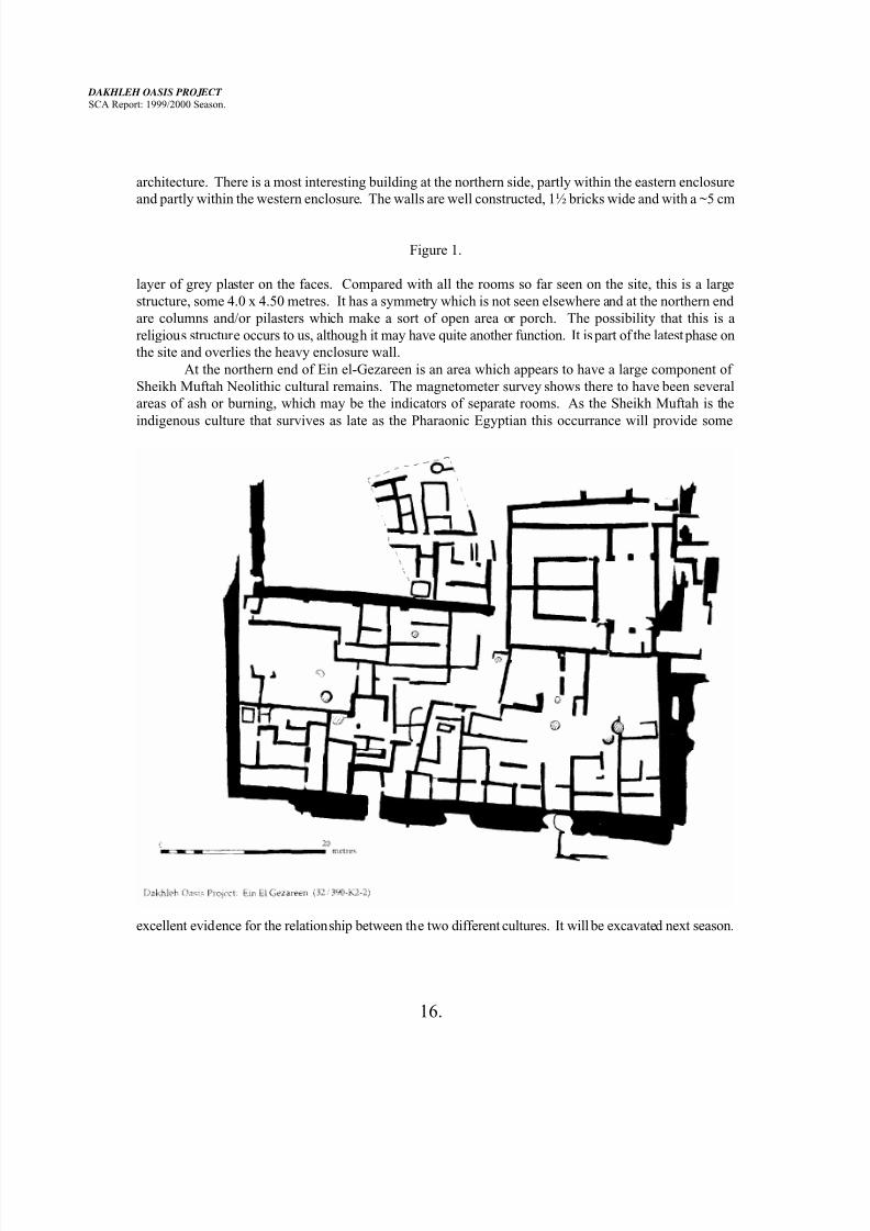
7. Ein el-Gezareen: 32/390-K2-2
This was the fourth season of field work at this Old Kingdom settlement site in western Dakhleh Oasis.
The first two seasons were occupied with the excavation of a 10m x 15m test area, which resulted in the
exposure of a bakery area. Last season began with a magnetometer survey of about ½ of the site area with
the spectacular results of the identification of a 55m x 105m enclosure with heavy outer walls. This
geophysical surveying was then confirmed in outline by excavating the outer wall of the enclosure and into
several of the adjacent rooms along the eastern side.
The 1999/2000 season has seen the extention of the sub-surface surveying by Dr. Smekalova over
almost all the site area, an extra 1.2 ha. Her results indicate many features and anomalies throughout the
whole area of the site. The magnetometer survey is being so successful at this site because a big contrast
exists between the mudbrick walls and the fill and because structures are situated only a very little distance
below the surface. As last season, the discoveries of this underground survey must be verified by
excavation. This will occur in future seasons.
Excavation during the weeks of this season’s field work concentrated upon the “eastern
enclosure”, that area bounded by heavy mud brick walls measuring about 55m x 25m which is situated to
the east of the large enclosure. Last season we had delineated the outer walls of this enclosure together
with a series of rooms lying along the inside of the eastern wall. This season we decided to undertake a
clearance of the surface features of the remainder of this eastern enclosure, only excavating a maximum of
about 10 centimetres. The results were rewarding.
There are over forty identifiable rooms within this space. Some of these are so large that they musthave been open-air and unroofed spaces. These generally show greater amounts of ash and burning areas
than the closed rooms. Several of the rooms have small patches of burning, often round and in the middle
of the floor, which seem to have been intended for room warmth rather than any industrial or even cooking
purpose. Several rooms had larger deposits of ash, which seem to have been baking fire accumulations.
The ceramics from the surface of the eastern enclosure have been treated as surface material, have been
collected, but have not yet been analysed. All do, however, date to the late sixth dynasty. Earlier material
may be recovered from lower levels after excavation begins.
Unlike the enclosure walls, some of which are 1.45 m wide and others nearly 3 metres, the walls of
the various rooms within are generally poorly constructed and either a single brick or 1½ bricks thick. It is
probable that the surface remains represent only the final occupation at the site. Stratified remains of
architecture have been evidenced in a few places and we expect that the plan of Fig. 1 will be altered
through excavation in the future.
The eastern and the western enclosures outer walls are not connected and the two are from twodistinct building phases. That wall which we are treating as the west wall of the eastern enclosure is in fact
the east wall of the western enclosure. It appears to have existed prior to the construction of the eastern
enclosure and at the southern end it can be seen to turn westwards while the south wall of the eastern
enclosure runs parallel to it but outside it. The magnetometer survey shows this wall as complete while
excavation reveals an interruption of nearly 4 metres at its northern end. Again, evidence of stratified
7/27/2019 Dakhleh Report 2000
http://slidepdf.com/reader/full/dakhleh-report-2000 16/22
DAKHLEH OASIS PROJECT
SCA Report: 1999/2000 Season.
16.
architecture. There is a most interesting building at the northern side, partly within the eastern enclosure
and partly within the western enclosure. The walls are well constructed, 1½ bricks wide and with a ~5 cm
Figure 1.
layer of grey plaster on the faces. Compared with all the rooms so far seen on the site, this is a large
structure, some 4.0 x 4.50 metres. It has a symmetry which is not seen elsewhere and at the northern end
are columns and/or pilasters which make a sort of open area or porch. The possibility that this is a
religious structure occurs to us, although it may have quite another function. It is part of the latest phase on
the site and overlies the heavy enclosure wall.
At the northern end of Ein el-Gezareen is an area which appears to have a large component of
Sheikh Muftah Neolithic cultural remains. The magnetometer survey shows there to have been several
areas of ash or burning, which may be the indicators of separate rooms. As the Sheikh Muftah is the
indigenous culture that survives as late as the Pharaonic Egyptian this occurrance will provide some
excellent evidence for the relationship between the two different cultures. It will be excavated next season.
7/27/2019 Dakhleh Report 2000
http://slidepdf.com/reader/full/dakhleh-report-2000 17/22
DAKHLEH OASIS PROJECT
SCA Report: 1999/2000 Season.
17.
8. Old Kingdom Watch Posts: 30/450-C4-1
O. E. Kaper, H. Willems, and L. Kuijper were the Project members to undertake this study in 1999/2000.They were in the field from 13 to 22 December, 1999.
Excavations were carried out at a new site, 30/450-C4-1, which lies at the eastern edge of ‘Camel
Thorn Basin’, some 8 km east of Teneida. The site consists of a hill with three stone shelters on the top. A
dense surface scatter of potsherds and flint dates the occupation to the Old Kingdom. A limited amount of
carvings in the rock helps to confirm this date.
The season started with a systematic collection of the surface material according to a 10m x 10m
grid. A trainee of the DOTACP was employed at this stage.
On 19 December work was started inside the three huts. Plans were drawn up of the site as a
whole and of each of the huts separately. The interiors of the three huts were excavated. The two smaller
huts on top of the hill proved to contain only little material. Only random potsherds and flint were found
and no botanical remains or remains of fire. The larger hut was associated with the most intense surface
scatter and its interior showed a more complex stratigraphy, demonstrating a longer period of use. Finds
include a grinding stone, some bone, mainly of gazelle, a piece of worked leather, limited amounts of
charcoal and again Old Kingdom potsherds and flint.
Excavation at this site will be finished in a future season.
Analysis of specific find categories was undertaken for ceramics (Hope), botanical remains
(Thanheiser) and zoological remains (Churcher).
9. Ismant el-Kharab (ancient Kellis): (31/420-D6-1) Provided elsewhere in these pages.
10. Amheida: 33/390-L9-1 This year marked the start of new work at Amheida under the auspices of Columbia University,
and jointly directed by Professor Roger Bagnall and Professor Lynn Meskell. In this preliminary season
several visits to the site were made for general reconnaissance, photography, and planning. Three areas of
the site were identified for minimal surface clearance and recording.
* Area 1 to the north of the site is an industrial area, showing evidence of kilns and vitrified material
adjacent to a major street. This area also extends westwards adjoining an area of elite structures with a
series of vaults and and painted plaster. We need to ascertain the extent of these buildings in order to plan
for conservation in subsequent seasons.
* Area 2 is approximately located in the middle of the site sloping upwards towards the west. It
consists of a set of interrelated rectilinear structures. Surface evidence reveals that almost all of these
rooms were plastered and/or painted. Towards the base of the slope are a series of rooms which have
vaulted roofs and possibly one that is domed: all appear to have wall decoration.
* Area 3 lies at the south-eastern edge of the site and is a highly enigmatic brick structure resemblingthe core of a pyramid. This large monumental structure is demonstrating signs of severe instability and we
may require consultation with a structural engineer before proceeding further. Our purpose at present is to
map this feature and the surrounding set of structures which have additional vaults. Some have suggested
the structure is funerary in purpose, however without systematic recording this issue will remain
unresolved.
7/27/2019 Dakhleh Report 2000
http://slidepdf.com/reader/full/dakhleh-report-2000 18/22
DAKHLEH OASIS PROJECT
SCA Report: 1999/2000 Season.
18.
In January these three areas were planned and drawn by J.E. Knudstad in preparation for further
planning of superstructures in 2001 and excavation in 2002. In conjunction with the architectural surveywe also initiated a geophysical survey under the direction of Tatyana Smekalova. With the results of the
subsurface survey in place we can establish potential areas for excavation in future years and also tracts of
land which will be suitable for the construction of buildings including a guard house and conservation and
pottery sheds.
11. Epigraphy. A third season of recording at the temple of Deir el-Hagar was conducted in February and March, 2000.
The work was directed by Dr. O.E. Kaper, who led a team of seven egyptologists from the Humboldt
University, Berlin.
During the 15 working days spent in the temple, seventeen previously unrecorded scenes were
copied onto plastic film. In addition, nine scenes could be finished in ink and several more drawings were
checked for accuracy against the original reliefs.
With the assistance of a local trainee, the Arabic graffiti in the temple were copied. Most of these
date between the years 1911 and 1921.
12. Physical Anthropology.
As this was planned as a study season, no excavation was undertaken by Professor J.E. Molto and his
group. Research and analysis was conducted on materials previously collected from 31/420-C5-2, (=
“Kellis 2") the eastern of the two cemeteries associated with Ismant el-Kharab.
Objectives of the 1999/2000 Season:
1. to analyze infant remains excavated in the previous field season ( n = 68),
2. to assess sacra for potential sexing methods,
3 to develop standards for aging fetal remains,4 to collect dental morphology from burials excavated in previous field seasons,
5 to collect modern buccal and hair samples from Ezbet Bashendi children for DNA and dietary
analysis.
The primary objective of the 1999 bioarchaeology component of the Dakhleh Oasis Project was
the analysis of subadult burials excavated but not analyzed in the previous season. This sub-sample
consists of 68 burials with the following demographic breakdown:
2nd trimester fetuses 3 (4.4%)
3rd trimester fetuses/neonates 13 (19.2%)
B - 1 year 17 (25.0%)
1 - 2 year 12 (17.6%)
2 - 3 year 3 (4.4%)
3 - 10 years 17 (25.0%)12 - 17 years 3 (4.4%)
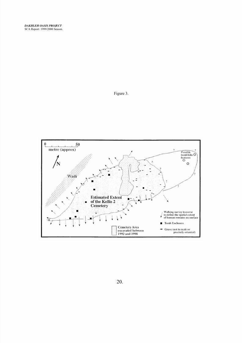
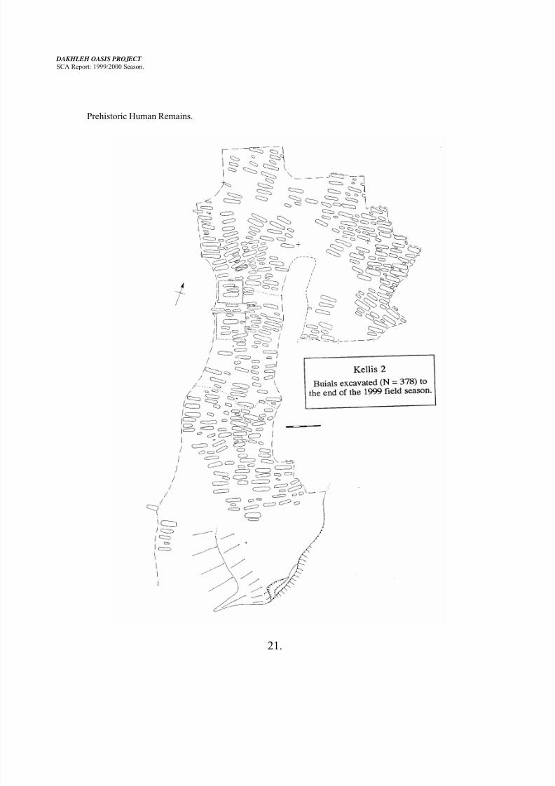
The total Kellis 2 sample of 378 burials is now sufficiently large for a detailed demographic
analysis (life tables, etc.), although the adult cohorts are still small for conducting detailed
palaeoepidemiological research. Fig. 3 provides a diagrammatic representation of the burials excavated
7/27/2019 Dakhleh Report 2000
http://slidepdf.com/reader/full/dakhleh-report-2000 19/22
DAKHLEH OASIS PROJECT
SCA Report: 1999/2000 Season.
19.
and analyzed to date. Fig 2 illustrates the size of this sample relative to the complete Kellis 2 cemetery.
The subadult sample analyzed this year has larger representation of fetal remains than the rest of
the cemetery. This may, in fact, represent a methodological bias as osteometric standards developed forfetuses in other populations were tested on the Kellis 2 sample. The large number of late fetuses may be a
concomitant of the fact that the Kellis 2 people are small and their birth sizes may reflect this
anthropometric (osteometric) characteristic. To date very few studies of population based on fetal aging
research have been attempted as most often few fetal remains are recovered in archaeological samples.
None of the subadult burials analyzed this year had any noteworthy osteopathologies, although
they do increase the overall sampling of these cohorts. In particlar, there were a large number of subadult
dentitions with dental caries and other dental pathologies which improves our statistical analysis for the
study of palaeeodietary aspects of this population.
Although most of the adult burials from the Kellis 2 population can be accurately sexed using hip
criteria, there are several burials for which sex is indeterminant. Most of these skeletons have intact sacra
and this with the fact that the samples from 31/420-C5-1 are all mixed (= each skeletal element has to be
studied separately) led to the decision to test various extant methods for sexing and aging the sacrum. The
sacra were collected at our storage area at the cemetery, were labelled, sorted by number and then analyzed
for several metric and non-metric variants in the laboratory at Ez. Bashendi. This study was done blind as
the sex and age of the burials (though previously recorded) was unknown to the researchers. The data will
be analyzed this year. The results could have implications for both the study of the Kellis population
samples and, of course, the field of bioarchaeology. In addition, the sacra were used for studies for the
presence of spina bifida occulta and other sacral variants (sacral hiatus level, sacralization of L5, etc.) This
research was primarily designed as an inter-observer reliability test for future publication of the sacral data.
In terms of the biochemical research, 100 children from Bashendi provided buccal samples and
hair (boys only). Clearance for the research was provided by the ethics committee at Lakehead University
and from local officials. The buccal samples will be used for DNA research. This will provide a modern
comparative sample by which to guage and interpret the palaeo-DNA evidence. Several of these samples
have already been analyzed and the yeild of DNA is sufficient for the study. The hair samples will beanalyzed for their isotopic signatures (13
C and15 N) and will provide a comparative measure for interpreting
the palaeo-dietary evidence for Kellis 2 and Ein Tirghi subadults.
In sum, this study season provided the opportunity to complete the analysis of the Kellis 2 sample
and to test and develop methods that will assist in the future interpretation of the bioarchaeology of this
unique population.
Figure 2.
7/27/2019 Dakhleh Report 2000
http://slidepdf.com/reader/full/dakhleh-report-2000 20/22
DAKHLEH OASIS PROJECT
SCA Report: 1999/2000 Season.
20.
Figure 3.
7/27/2019 Dakhleh Report 2000
http://slidepdf.com/reader/full/dakhleh-report-2000 21/22
DAKHLEH OASIS PROJECT
SCA Report: 1999/2000 Season.
21.
Prehistoric Human Remains.
7/27/2019 Dakhleh Report 2000
http://slidepdf.com/reader/full/dakhleh-report-2000 22/22
DAKHLEH OASIS PROJECT
SCA Report: 1999/2000 Season.
22.
Dr. J. Thompson joined the field camp from 5th to 15th January, 2000, and spent this season
undertaking a complete dental analysis of 5 Neolithi c skeletons excavated in previous years. One of the
more complete skulls was partially reconstructed providing valuable cranio-facial dimensions forcomparative analysis. G. Madden assisted in the analysis of these individuals - cleaning the bones,
providing a detailed inventory, and undertaking metric, non-metric, and palaeopathological analysis of the
skeletal material.
Dr. Thompson and G. Madden accompanied Dr. M. McDonald to Loc. 100 (31/420-P5-1) , west
of Balat. Here a Neolithic skeleton had been discovered and partially collected in 1982. The remainder of
this individual was discovered by G. Madden. A second individual was discovered but left in situ for
recovery next season.
The total number of excavated Neolithic specimens now amounts to 6 individuals: three from 365,
two from 375, and the newly excavated partial skeleton from Loc. 100.
13. Conclusion.
The 1999-2000 season of the Dakhleh Oasis Project has been one of excellent results from manydifferent fields of scholarship, from environmental studies to physical anthropology and historical
archaeology. The regional study of the interaction of environmental change and human activity
has so many components that it perforce progresses slowly but surely, with new information every
season. Future plans include working at new sites, Mut el-Kharab and el-Muzzawaka, and
returning to all the Old Kingdom sites - Ein el-Gezareen and the Watch Post sites - and
continuing at Ismant el-Kharab and its cemeteries. Our prehistorians intend to continue with their
individual studies in eastern Dakhleh Oasis and in Kharga Oasis. Environmentalists are each in
the midst of studies and intend to continue these. This work would not be possible without the full
cooperation and participation of various of our Egyptian colleagues. In particular, Mr. Ashraf el-
Sayed Mahmoud of Sohag, continues to be an invaluable co-worker and SCA representative.
Anthony J. MillsDirector.