issn 1410-7821, volume 2, no. 1, 1999 · natsir nessa sekretaris redaksi ( editorial secretary)...
TRANSCRIPT
ISSN 1410-7821, Volume 2, No. 1, 1999
Pemimpin Redaksi(Editor - in- Chief)
Dietriech G. Bengen
Dewan Redaksi(Editorial Board)
Rokhmin DahuriIan M. Dutton
Richardus F. KaswadjiJacub Rais
Chou Loke MingDarmawan
Neviaty P. Zamani
Konsultan Redaksi(Consulting Editors)
Herman Haeruman Js.Anugerah Nontji
Aprilani SoegiartoIrwandi Idris
Sapta Putra GintingTridoyo Kusumastanto
Chairul MulukEffendy A. Sumardja
Iwan GunawanDaniel Mohammad Rosyid
Gayatrie R. LileyJanny D. Kusen
J. Wenno, N.N.Natsir Nessa
Sekretaris Redaksi( Editorial Secretary)Siti Nurwati Hodijah
Alamat Redaksi(Editorial Address)
Pusat Kajian Sumberdaya Pesisir dan Lautan(Center for Coastal and Marine Resources Studies)Gedung Marine Center Lt. 4, Fakultas Perikanan IPB
Kampus IPB Darmaga Bogor 16680 INDONESIATel/Fax. 62-251-621086, Tel. 62-251-626380
e-mail: [email protected] muka: Teluk Manado (foto: Bengen, D.G., 1998)
i
Pada edisi ketiga jurnal �Pesisir & Lautan� ini, kami hadir dengan format dan tampilan yang lebihkomunikatif dan menarik.
Mengingat bahwa kebutuhan untuk berbagi pengalaman dan pengetahuan terus meningkat, makaberdasarkan saran-saran dan masukan-masukan yang kami peroleh dari para penelaah dan pembaca,jurnal �Pesisir & Lautan� akan hadir ke hadapan Anda tiga kali dalam setahun dimulai sejak penerbitanedisi ketiga ini.
Semoga jurnal ini dapat menjadi suatu media informasi bagi para pemerhati maupun praktisi pengelolaansumberdaya pesisir dan lautan.
Selamat membaca dan kontribusi Anda kami nantikan.
For the third edition of �Pesisir & Lautan� journal, we have redesigned the format and appearance,in order to make it more attractive and communicative.
The need for sharing experience and knowledge is increasing from day to day; hence, in responseto many suggestion and inputs from reviewers, readers and subscribers (both domestic and abroad), wehave decided that the journal will be published three times a year commencing this edition.
We hope that this journal will be more attractive as information exchange platform to all peopleconcerned with coastal and marine resources and their management.
Enjoy your reading and we are waiting for your contribution as well !
Pemimpin RedaksiEditor-in-Chief
Dr. Ir. Dietriech G. Bengen
A COMPARISON OF LEVEL OF DEVELOPMENTAMONG COASTAL AND NON-COASTAL COMMUNITIES
IN NORTH SULAWESI AND SOUTH SUMATRA
BRIAN R. CRAWFORDPRICIELLA KUSSOY
Coastal Resources Management Project – Indonesia
RICHARD B. POLLNACCoastal Resources Center – University of Rhode Island
M. FEDI A. SONDITACenter for Coastal and Marine Resources Studies – Bogor Agricultural University
ABSTRACT
his paper examines the question as to whether coastal communities and fishers in Indonesia are the poorest of thepoor. It reviews recent socio-economic studies on coastal communities in Indonesia, and provides a quantitativeanalysis of secondary data on coastal and non-coastal communities in North Sulawesi in relation to IDT and Swa
development classifications, as well as percent and density of fishers and farmers for coastal villages in Minahasa. Italso provides an analysis of secondary data on income levels of farming and fishing communities in South Sumatra. Itconcludes that coastal communities in Minahasa, North Sulawesi tend to be less developed than non-coastalcommunities. The less developed status of coastal communities is not related to fisher density, fisher percent, or farmerdensity and has only a weak relationship to percent farmers. Isolation appears to be an important factor. In SouthSumatra, percent fishers in a community was positively correlated with higher average household income while percentfarmers was negatively correlated with higher income. The paper concludes that the generalized statement that coastalcommunities are less developed and fishers are the poorest of the poor in Indonesia cannot be supported due to thesignificant diversity among the level of development of coastal communities and income levels of fishers in variouslocalities. Coastal development and resource management planning programs need to take such diversity into account,which suggests a need for more decentralized approaches to governance.Keywords: income, poverty, fishers, coastal villages, level of development, decentralization
Abstrak
Tulisan ini menganalisa mengenai pernyataan bahwa masyarakat nelayan pesisir merupakan kelompok termiskindan mencoba mengkaji ulang studi sosial ekonomi yang sudah dilakukan sebelumnya tentang masyarakat pesisir diIndonesia. Studi-studi ini didukung pula analisis kuantitatif data skunder kelompok masyarakat pesisir dan non pesisirdi daerah IDT dengan daerah-daerah yang lebih makmur, juga presentase dan kelimpahan nelayan dan petani di desa-desa pesisir di Minahasa. Data skunder tingkat pendapatan petani dan nelayan di Sumatera Selatan dijadikanperbandingan dasar analisis pula. Hasilnya menunjukan bahwa masyarakat pesisir Minahasa, Sulawesi Utaracenderung lebih miskin dibandingkan masyarakat non pesisir di daerah itu. Akan tetapi pernyataan tersebut tidak adakaitannya dengan kepadatan dan persentase nelayan, atau kelimpahan petani dan persentase petanipun sangat kecilsekali. Anggapan ini muncul sebagai faktor penting. Dari hasil laporan di Sumatra Selatan, faktor persentase nelayandalam suatu kelompok berkorelasi positif dengan tingkat pendapatan rata-rata rumah tangga yang lebih tinggi,sementara tingkat pendapatan petani yang lebih tinggi berkorelasi negatif terhadap persentase petani di daerah tersebut.Dari analisis ini disimpulkan bahwa pernyataan umum mengenai masyarakat pesisir merupakan kelompok termiskintidak dapat didukung karena keberagaman diantara tingkat kemajuan dan pendapatan nelayan di daerah-daerah yangberbeda. Program -program Perencanaan dalam pengelolaan pengembangan wilayah pesisir dan sumberdayanyahendaknya memasukan keanekaragaman masalah kedalamnya, dimana membayangkan suatu keperluan yang lebihpada pendekatan desentralisasi pemerintahan.Keywords: pendapatan, kemiskinan, nelayan, desa-desa pesisir, tingkat perkembangan, desentralisasi
T
INTRODUCTION
A number of recent reports and socio-economic studies in Indonesia have made statementsconcerning poverty and income levels of coastal communities and fishers. A Ministry ofEnvironment report stated that fishers with small boats generally live below the poverty level andthat coastal villages generally have a poor quality of life (MSE, 1996). A North Sulawesi (MREP,1996a) study reports that fishing in the region is carried out by poor fishers and that most of theresidents in the coastal area studied have low incomes. The report also states that many of the poorvillages which receive IDT funds (a government program for poor villages) have residents whichare fishers. In addition, they conclude that the coastal villages surveyed are poor due to the factthat they rely on fishing, have poor marketing systems, an absence of cold storage facilities andbecause they are isolated. The report however, contains no quantitative data backing theseconclusions. In another study of 132 households surveyed in four coastal communities on the eastcoast of Minahasa (Pollnac, et al., 1998), fisher households manifest a lower level of material styleof life as indicated by items such as household structural features, furnishings, and appliances. Thissuggests that fisher households in these communities tend to be poorer than households wherefishing is not one of the top three ranked productive activities.
A study from Irian Jaya reports that fisher incomes are low to medium (MREP, 1996b). Noreference is made to actual average fisher incomes or what they are compared to for concludingtheir incomes are low to medium. A South Sulawesi study finds that fishers in the communitiessurveyed have no income from sources other than fishing (MREP, 1996c). Ranges of income forrespondents in the coastal communities surveyed is reported, but no conclusions on the povertylevel of fishers or the coastal communities surveyed are made. A review of data in their reporthowever, indicates that coastal fishers have incomes lower than brackishwater farmers.Brackishwater farmers are the highest income group in all the coastal villages sampled. However,in comparing incomes with rice farmers, some villages show higher income from fishing whereasothers show higher income from rice farming.
In contrast to the above mentioned studies which tend to highlight the poverty of coastalcommunities and fishers, a study from South Sumatra (MREP, 1995) concludes that in all of thecoastal communities studied, household income levels are above the poverty level. They alsoreport that coastal communities have a high level of occupational multiplicity dominated byfarming and fishing, which may be one of the factors accounting for the high income levels. Inaddition, they conclude that household income levels for fisher crews are the lowest while levelsfor fishers who own good gear is the highest. A study of the economic value of fisheries inBunaken National Marine Park, North Sulawesi (NRMP, 1996) concludes that fishers in the parkare not poor and income levels are not low. Income levels for fishing (artisanal and commercial)and seaweed farming households are reported to be two to three times higher than income levels ofunskilled labor single income households in Manado, the major urban center of North Sulawesi.An earlier study of fishing communities in Bunaken Park (Pontoh, 1991) concludes that fishingincomes are from 62 to 75 percent lower than the national per capita income. However, noinformation is provided on how non-coastal communities or non-fisher households in NorthSulawesi compare to this level.
None of the studies described above have made detailed comparisons between coastal and non-coastal communities, and only a few have attempted to compare fishers to other occupationalgroups. However, many of the reports make statements about the poverty of coastal communitiesand fishers with little or no supporting evidence. The literature review indicates that suchstatements may be true for one region or village but not for another. Hence, this previous researchdoes not support a generalized conclusion for Indonesia that coastal villages are less developed andfishers are the poorest of the poor. This can have important implications for coastal resources
management, development, planning, and policy programs. If based on inaccurate assumptions orconclusions, these programs may not achieve the expected results.
Testing assumptions concerning income levels of individuals in fishing as well as otheroccupational categories can be problematic. It is often difficult to obtain information on incomelevels or the standard of living of fishers as well as individuals in other rural occupations. Inaddition, there is often no clear cut distinction among occupations of individuals as being a full-time fisher or farmer. Often, individuals and households in rural communities obtain income fromseveral occupational sources and engage in a multitude of productive activities. This is particularlyevident in coastal communities of Minahasa where households can engage in four or moreproductive activities, which may or may not be a combination of land and sea-based activities(Pollnac et al., 1997). It is also important to note that not all productive activities result in income,and it is typical for rural coastal households to engage in both income generating and subsistenceactivities. By concentrating only on income, we may exclude many important productive activitieswhich contribute to the quality of life of coastal household members, but which can be difficult toplace a monetary value on. Additionally, many fishers are also part-time farmers and visa versa, soclear cut distinctions between fishers and farmers as occupational categories can be meaningless. Itcan be argued that exploitation of multiple land and sea-based coastal resources for incomegenerating and subsistence activities is an optimal adaptation for coastal communities. However, italso makes the job of social science research in these communities more challenging.
Rather than attempting to look at differences in the income levels of different occupationalgroups, another strategy is to examine differences in the level of development or well being ofvarious types of communities. Community-based coastal resources management programstypically target the community as a whole rather than any one occupational group. From a coastalresources management and development planning policy perspective, understanding how coastalcommunities fare relative to other non-coastal communities can be an important consideration andjustification for targeting specific programs towards coastal communities.
METHODOLOGYMinahasa and North Sulawesi: Information on the development status of villages (as defined
by government agencies and available from existing secondary data sources) within North Sulawesiand the Minahasa Regency are analyzed to determine whether coastal communities are in general,less developed or poorer than their non-coastal counterparts. Two types of Government ofIndonesia (GOI) classifications for level of village development are used. One is based on a systemof classification of villages as IDT (Inpres Desa Tertinggal) or non-IDT (poor or non-poor villages,respectively) devised by BAPPENAS (National Development Planning Board), BPS (CentralStatistics Bureau) and Departemen Dalam Negeri (Department of Home Affairs) to provide specialdevelopment funds to "poor" villages (BPS, 1995). Criteria for classifying villages as IDT or non-IDT includes opinions of local government officials as well as summary scores on approximately18 variables such as health, education, communications and transportation facilities, drinking watersupply, electrification, occupation of residents, among others. The other system of classificationdevised by the Dirjen BANGDA (Directorate General for Regional Development) and KantorPembangunan Masyarakat Desa (Village Community Development Office) divides villages intothree "Swa" (self-effort) categories: Swadaya, Swakarya and Swasembada (PMD, 1998). Thesethree categories grade villages as less-developed, middle-developed or more-developedrespectively. This classification is based on six criteria including public education and health;safety, law and order; level of village economy, community participation, understanding of thebasic principals of the state ideology of Pancasila, and the awareness of Indonesia as a nation-state.
A review of statistics (BPS, 1996) for the development classifications are made for NorthSulawesi Province to determine whether there are relationships between percent of coastal villageswithin kabupatens with the percent of villages in the various development classifications. A more
detailed analysis of village level information for the Minahasa regency is then conducted to furtherexamine the relationships. Information on IDT (BPS, 1995), and Swa (BPS, 1993) classificationsobtained for all coastal and non-coastal villages in Minahasa is compared using statistical analyses.
Several hypotheses are tested which might explain the low level of development of coastalcommunities in Minahasa. Village level data obtained (BPS, 1993) from various Bureau ofStatistics documents are analyzed to see if there is a relationship between the various developmentcategories and percent of fishers or farmers, or fisher and farmer density in the coastal villages.Percent fishers and percent farmers (the largest occupational subcategories in rural Minahasancoastal villages) are calculated by dividing the number of individuals identified as employed ineach category by the total village population. Fisher density and farmer density are determined foreach coastal village by dividing the number of individuals identified as employed in this categoryby the total land area of the village. A t-test is used to examine differences of the means of thesevariables with the IDT and Swa classifications. Due to the low frequency of villages classified asSwadaya, the three-level Swa classification is collapsed into a low-swa (swadaya and swakarya)and high-swa (swasembada) classification for this analysis. Another possible explanation for thelow level of development of coastal communities is that geographic isolation may be a contributingfactor. This hypothesis is tested by scoring all coastal villages as either isolated or non-isolated andcomparing this with the village development categories. Isolated communities are defined as thoseon offshore islands, or with poor road infrastructure to and from the village.
South Sumatra: An analysis of summary data reported on 19 villages from South Sumatra(MREP, 1995) is conducted to test differences between percent fishers and farmers with respect toaverage household income levels. A Pearson correlation is ran on these data. Two of the villagesin this group are non-coastal (do not border on the coast) but have marine fishers as an occupationalgroup within the community. A scatter plot of percent fishers versus percent farmers for the 19villages in the study is made to determine potential clustered relationships among the villages. Theraw data on individual household income is unavailable for analysis. Therefore, average annualhousehold incomes for each cluster reported in the results are the averages of the village averages,not average household income of all respondents surveyed in the villages which are containedwithin the cluster. Since an average of averages can be grossly misleading where sample sizes ineach subgroup (village) are different or unknown, the raw data for average household income ofeach village can be found in Table 6.
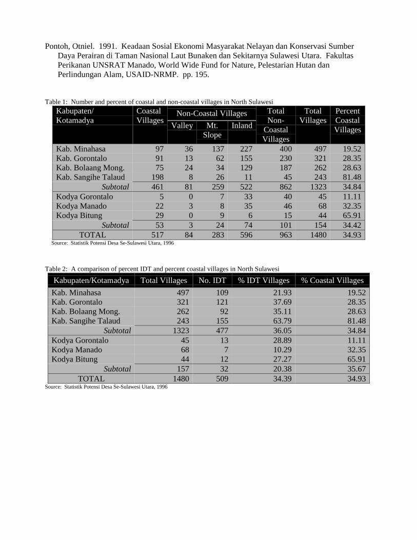
RESULTSNorth Sulawesi: The number and percent of coastal villages in North Sulawesi for Regencies
(Kabupaten) which are predominantly rural administrative units, versus urban (Kotamadya)administrative units are provided in Table 1. The overall percentage of coastal versus non-coastalvillages for urban and rural administrations are the same. However, they exhibit a wide range ofvariation from one administration to the other. Slightly more than one third of all villages in NorthSulawesi are coastal. The percentage of coastal and IDT villages in the various administrations iscompared in Table 2. The rural administrations have a higher percentage of IDT villages thanurban administrations. Within rural administrations, those with a higher percentage of coastalcommunities also have a higher percentage of IDT villages. The urban administrations show nosuch distinction.
A comparison of percent coastal and percent of categories of "Swa" villages in North Sulawesiis presented in Table 3. Urban administrations tend to have a higher percentage of more-developed(Swasembada) villages than rural administrations. The majority of urban administration villagesalso fall into the more-developed category. The rural administrations tend to have slightly moreless-developed (Swadaya) villages than urban administrations. The rural administrations havesubstantially more middle-developed (Swakarya) and substantially less more-developed(Swasembada) villages. The relationship between percent coastal and percent "Swa" categories is
less distinct for rural administrations and no relationship is evident for urban administrations. Allurban administrations have a higher percentage of Swasembada villages than the ruraladministrations.
Minahasa has the lowest percentage of coastal and IDT villages among the Kabupaten (rural)administrations. In addition, Minahasa has the highest percentage of Swasembada and lowestpercentage of Swadaya villages for Kabupaten administrations. The IDT and "Swa" classificationssuggest that Minahasa is one of the more developed Kabupatens within the Province of NorthSulawesi. Minahasa has a similar percentage of IDT villages (21.9 percent) as the average forKotamadya (urban) administrations (20.4 percent). However, the "Swa" classifications rank itlower than the urban administrations, but the highest among the rural Kabupatens.
The relationship between percentage of coastal villages with IDT and Swa classificationsaggregated at the Kabupaten level suggests that there may be a relationship between coastalvillages and the Swa and IDT classifications. Caution is needed in attempting to draw parallels tourban (Kotamadya) administrations where this relationship does not appear to hold.
A more detailed analysis of village level data in the Minahasa Regency may provide additionalinformation concerning the relationship between coastal residence and level of development. Outof a total of 495 villages in Minahasa, 111 are classified as coastal. (BPS, 1993). Comparingcoastal and inland villages in Minahasa on the basis of IDT classification indicates that 47 percentof the coastal villages are classified as IDT in contrast to only 15 percent of the inland villages.This difference is statistically significant ((2 = 51.36, df = 2, phi = 0.32, p < 0.001). Similarly,when comparing coastal and inland villages on the basis of the "swa" categories, 75 percent of theinland are classified as swasembada (the highest level) in contrast to only 45 percent of the coastal((2 = 35.68, df = 2, phi = 0.27, p < 0.001). These results indicate that coastal villages tend to havemore IDT classified villages and more villages classified into lower "Swa" categories. Therefore,coastal communities in Minahasa are more likely to be poorer or less developed than their non-coastal counterparts. These findings suggest that some characteristic of the coastal villages hasimpeded their development.
Results of the analysis testing the hypotheses that percent fisher and farmer, and fisher andfarmer density may be related to level of development are presented in Tables 4 and 5. Tables 4 &5 indicate that there is no difference in fisher density or percent fishermen in the differentdevelopment classifications of coastal villages. The means in the tables are not to be considered asrepresenting overall mean fisher density or mean percent fisher since the population of the includedvillages varies. There is no significant difference in percent farmers in IDT and non-IDT coastalvillages. However, there is a difference in percent farmer in low-swa (swadaya and swakarya) andhigh-swa (swasembada) coastal villages. Coastal villages with a higher percent of farmers tend tobe classified as low-swa. While this is statistically significant, the actual difference is quite small(.296 versus .234) suggesting it may not be a useful factor in explaining differences in level ofvillage development, particularly considering there was no significant difference for this variable inthe IDT classifications.
One potential explanation for this difference may be that arable land in coastal communities isless available or less fertile, or irrigation and water resources are not as well developed, resulting inlower productivity and potential income. Therefore, coastal communities with more farmers maytend to be poorer for this reason. Nevertheless, farmer density is not significantly different in thedifferent development classifications of coastal villages. Since not all land within a community isarable, farmer density (number of farmers per unit of total village land area) may not be a goodfactor for explaining the level of development or poverty status of coastal communities.Calculating farmer density using total arable land rather than total land may be a better variable touse in future analyses of this nature.
Since fisher percent and fisher density does not seem to be a significant factor, other factorsmay be more important in explaining the difference in the level of development of coastal
communities. When comparing isolation with IDT classifications, only 42 percent of non-IDTcoastal villages are isolated whereas 80 percent of IDT coastal villages are isolated ((2 = 16.475, df= 1, phi = 0.387, p < 0.001). This relationship is similar for Swa classifications where only 34percent of Swasembada (high-swa) coastal villages are isolated while 82 percent of Swadaya andSwakarya (low-swa) coastal villages are isolated ((2 = 25.819, df = 1, phi = 0.484, p < 0.001).Hence, geographic isolation appears to play a role in the development of coastal villages.
South Sumatra: Percent fishers in the South Sumatra communities is positively correlated (r =0.568, p < .02) with average household income, and percent farmers in the community is negativelycorrelated (r = -0.543, p < .02) with average household income. Hence, coastal communities withhigher percentages of fishers tend to have higher average household incomes, and coastalcommunities with higher percentages of farmers tend to have lower average household incomes. Inthis case, communities with a high percentage of fishers on average are not the poorest of the poor,and the presence of large numbers of fishers tends to increase average household incomes in thosevillages.
A scatter plot of percent fishers versus percent farmers for the 19 villages in the study ispresented in Figure 1. The villages are clustered into four categories representing differentoccupational groups. The A cluster can be characterized as business and service dominatedvillages with next to the highest average annual household incomes (see Table 6). The B clusterare farmer dominated villages with next to the lowest average annual household incomes. In two-thirds of the cluster C villages, fishers outnumber farmers, but in one-third of the villages, fishersequals farmers. These villages have the lowest average annual household incomes. The cluster Dvillages are fisher dominated non-farming villages with the highest average household incomes.Average household incomes of fisher dominated villages is equal to or greater than farmerdominated villages and more on par with the business and service dominated villages. In theseSouth Sumatra villages, the presence of fishers tends to increase average household incomes in thecommunity and places them as some of the better off communities. This is contrast to the results ofthe village analysis in Minahasa where percent fishers is not related to the level of villagedevelopment, and the four east coast villages analyzed (Pollnac et al., 1998), where fisherhouseholds tend to have lower levels of material style of life items than farming households. TheBunaken Marine Park study (NRMP, 1996), however, produced similar results to the SouthSumatra analysis, concluding that fishers are not poor.
DISCUSSIONNorth Sulawesi, and Minahasa: In the Minahasa Regency of North Sulawesi, coastal
communities tend to be less developed or poorer than non-coastal villages. This relationship isbased on the definition and criteria of the Government of Indonesia IDT and "Swa" developmentclassifications. While coastal villages in Minahasa tend to be poorer than non-coastal villages, notall coastal villages are poorer than their non-coastal neighbors. This is a statistical relationship, andone must remember that more than one-half the coastal villages in Minahasa are non-IDT.Furthermore, this information does not provide us with any direct indication of whether fishers asan occupational group are poorer than other occupational categories.
The reasons why coastal communities in Minahasa tend to be less developed are not fullyunderstood. It may be due to ecological differences of coastal communities (agricultural soils maybe poorer, freshwater supply less available), or that infrastructure (for marketing marine oragricultural produce) is less developed in comparison with their non-coastal neighbors. There is noindication that percent fishers in a community or the number of fishers per unit area of village landis related to level of development. The percentage of farmers in the community may have someinfluence, but this relationship is weak and needs further investigation. Geographic isolation,however, is a relatively strong predictor of coastal community development as defined here. This
suggests that improvements in transportation infrastructure can be an important strategy to fosterthe development of coastal communities.
While we have no data to support this assertion, another potential reason why coastalcommunities tend to be less developed in Minahasa may be that government developmentprograms have not targeted coastal communities as much as perhaps they should. This suggeststhat further research is necessary. In addition, government programs designed for all communitiesregardless of geographic location may not be appropriate for coastal communities and thereforemay have less of an impact. Another explanation may be that the Swa and IDT classifications tendto overemphasize factors such as physical facilities (schools, health centers, etc.). This might tendto magnify infrastructure differences between communities rather than accurately reflect othermeasures of quality of life (infant mortality or income) which are not used in the IDT and Swaclassifications. More research is needed to better understand the tendency of coastal communitiesin Minahasa to be lesser developed. Regardless of the reasons, the fact that coastal communitiestend to be poorer in Minahasa provides justification for designing development programsspecifically for coastal villages.
Since rural coastal communities are heavily dependent on the coastal resource base for theirlivelihood, community-based coastal resources management initiatives can be an appropriateresponse to address the lesser developed state of coastal villages in Minahasa. Such programshowever need to view coastal communities as unique geographic areas where the productiveactivities of many coastal residents are dependent on both land and sea-based resources. Hence anintegrated approach to their development is needed which considers issues concerning thedevelopment and management of coastal agriculture, fisheries, freshwater resources andtransportation infrastructure, among other factors.
There is no clear indication that fishers are the poorest of the poor in Minahasa. There areexamples in North Sulawesi where fishers are better off than other occupational groups, whereas inother cases they tend to be poorer. Such variation is also seen among other provinces in Indonesiaincluding South Sulawesi and South Sumatra.
South Sumatra: In the case of South Sumatra, fisher dominated communities tend to be betteroff or equal to farmer dominated communities. Using income as the criteria for level ofdevelopment indicates that fisher dominated communities in the South Sumatra are not the poorestof the poor. Some fishers (crew) are among the poorest of the poor, but others (gear owners)clearly can be considered as among the better off. It is possible however, that the income of otheroccupational groups in the communities studied is so high that it is their income, not the fishers,that influence the high average household income. The IDT and Swa village developmentclassifications rely on factors other than income and it is not known how the South Sumatracommunities fare with respect to these classifications, or whether income is correlated to them.Further research in this area would be useful.
General Conclusions: Caution must be used in making generalized statements about fishersbeing poor without supporting empirical evidence for the locality concerned. The tendency ofcoastal communities to be poorer in some localities is not necessarily related to the presence offishers within the coastal communities. This may be surprising to some policy makers who oftenview the most obvious difference between coastal and non-coastal communities as the presence of afisheries sector. This may lead to the mistaken judgement that the poor condition of the communityis related to underdevelopment of the fisheries sector or that all fishing communities must be poor.
The diversity of the level of development between coastal and non-coastal communities, as wellas within coastal communities is great. Such diversity is also evident in the level of well beingbetween and within occupational groups. Development policies and management programs whichare applied across communities and occupational groups without accounting for such differencesare thus unlikely to succeed. Greater consideration therefore should be given to decentralized andflexible coastal management policies and programs for Indonesia which take into account the
diversity of village development levels and the diversity in the well being of various coastaloccupational groups.
REFERENCESBPS. 1993, Statistik Potensi Desa Tahun 1993, Biro Pusat Statistik, Sulawesi Utara.
BPS. 1995. Penentuan Desa Tertinggal 1994, Penjelasan Singkat, 1995, Biro Pusat Statistik,Jakarta.
BPS. 1996. Statistik Potensi Desa Se-Sulawesi Utara, 1996. Biro Pusat Statistik, Sulawesi Utara.
MREP. 1995. Studi sosial ekonomi dan lingkungan di kawasan pesisir dan laut Selat Bangka,Sumatera Selatan. PPLH Universitas Sriwijaya and Ditjen Pembangunan Daerah. pp. 125.
MREP. 1996a. Studi sosial ekonomi dan lingkungan di kawasan pesisir laut (MCMA) ManadoKarakelang Sulawesi Utara. PSLH Universitas Sam Ratulangi dan Ditjen PembangunanDaerah. pp 118.
MREP. 1996b. Studi sosial ekonomi, budaya dan lingkungan Proyek MREP Kawasan MCMABiak Numfor - Irian Jaya. PSL Universitas Pattimura dan Ditjen Pembangunan Daerah. pp.111.
MREP. 1996c. Studi sosial ekonomi dan lingkungan di kawasan pesisir dan laut (MCMA) Majene- Ujung Pandang Sulawesi Selatan. PSLH Universitas Hasanuddin dan Ditjen PembangunanDaerah. pp. 201.
MSE. 1996. Indonesia's Marine Environment: A Summary of Policies, Strategies, Actions andIssues. Ministry of State for Environment, Jakarta. pp. 86.
NRMP. 1996. Economic Value of Fisheries to the Residents of Bunaken National Marine Park.Natural Resources Management Project Report No. 62. BAPPENAS - Ministry of Forestry,assisted by USAID. Associates in Rural Development for Office of Rural and EnvironmentalManagement, USAID - Jakarta. pp. 76.
PMD. 1995. Kantor Pembangunan Masyarakat Desa (Village Community Development Office),Sulawesi Utara.
PMD. 1998. Personal communication, Kepala Bidang Pengembangan Desa, KantorPengembangan Masyarakat Desa, Manado.
Pollnac, R.B., C. Rotinsulu, B. Crawford, P. Kussoy, A. Siahainenia. 1998. An Examination andComparison of Rumbia and Minanga: Control Villages for the Coastal Resources ManagementProject Sites at Bentenan and Tumbak. Coastal Resources Center, University of Rhode Island,Narragansett, RI, USA. pp. 23.
Pollnac, R.B., F. Sondita, B. Crawford, E. Mantjoro, C. Rotinsulu, A. Siahainenia. 1997. Baselineassessment of socioeconomic aspects of resource use in the coastal zone of Bentenan andTumbak. Coastal Resources Center, University of Rhode Island, Narragansett, RI, USA. pp.79.
Pontoh, Otniel. 1991. Keadaan Sosial Ekonomi Masyarakat Nelayan dan Konservasi SumberDaya Perairan di Taman Nasional Laut Bunaken dan Sekitarnya Sulawesi Utara. FakultasPerikanan UNSRAT Manado, World Wide Fund for Nature, Pelestarian Hutan danPerlindungan Alam, USAID-NRMP. pp. 195.
Table 1: Number and percent of coastal and non-coastal villages in North Sulawesi
Non-Coastal VillagesKabupaten/Kotamadya
CoastalVillages Valley Mt.
SlopeInland
TotalNon-
CoastalVillages
TotalVillages
PercentCoastalVillages
Kab. Minahasa 97 36 137 227 400 497 19.52Kab. Gorontalo 91 13 62 155 230 321 28.35Kab. Bolaang Mong. 75 24 34 129 187 262 28.63Kab. Sangihe Talaud 198 8 26 11 45 243 81.48
Subtotal 461 81 259 522 862 1323 34.84Kodya Gorontalo 5 0 7 33 40 45 11.11Kodya Manado 22 3 8 35 46 68 32.35Kodya Bitung 29 0 9 6 15 44 65.91
Subtotal 53 3 24 74 101 154 34.42TOTAL 517 84 283 596 963 1480 34.93
Source: Statistik Potensi Desa Se-Sulawesi Utara, 1996
Table 2: A comparison of percent IDT and percent coastal villages in North Sulawesi
Kabupaten/Kotamadya Total Villages No. IDT % IDT Villages % Coastal VillagesKab. Minahasa 497 109 21.93 19.52Kab. Gorontalo 321 121 37.69 28.35Kab. Bolaang Mong. 262 92 35.11 28.63Kab. Sangihe Talaud 243 155 63.79 81.48
Subtotal 1323 477 36.05 34.84Kodya Gorontalo 45 13 28.89 11.11Kodya Manado 68 7 10.29 32.35Kodya Bitung 44 12 27.27 65.91
Subtotal 157 32 20.38 35.67TOTAL 1480 509 34.39 34.93
Source: Statistik Potensi Desa Se-Sulawesi Utara, 1996
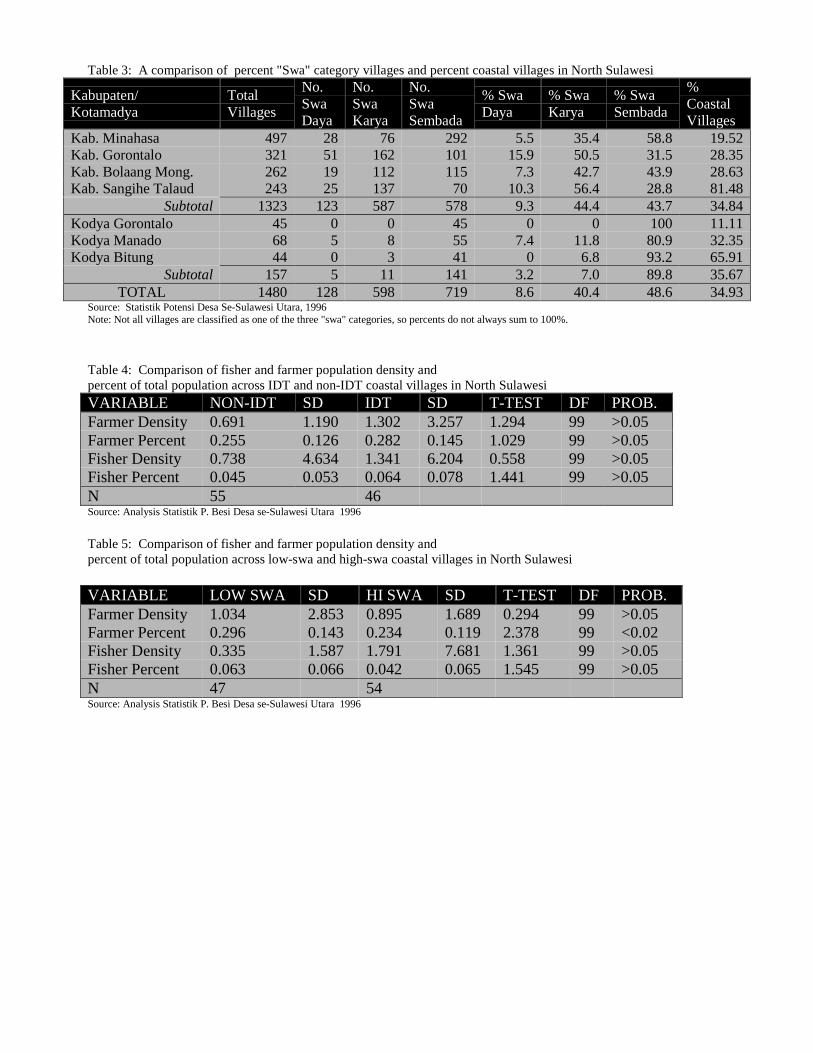
Table 3: A comparison of percent "Swa" category villages and percent coastal villages in North Sulawesi
Kabupaten/Kotamadya
TotalVillages
No.SwaDaya
No.SwaKarya
No.SwaSembada
% SwaDaya
% SwaKarya
% SwaSembada
%CoastalVillages
Kab. Minahasa 497 28 76 292 5.5 35.4 58.8 19.52Kab. Gorontalo 321 51 162 101 15.9 50.5 31.5 28.35Kab. Bolaang Mong. 262 19 112 115 7.3 42.7 43.9 28.63Kab. Sangihe Talaud 243 25 137 70 10.3 56.4 28.8 81.48
Subtotal 1323 123 587 578 9.3 44.4 43.7 34.84Kodya Gorontalo 45 0 0 45 0 0 100 11.11Kodya Manado 68 5 8 55 7.4 11.8 80.9 32.35Kodya Bitung 44 0 3 41 0 6.8 93.2 65.91
Subtotal 157 5 11 141 3.2 7.0 89.8 35.67TOTAL 1480 128 598 719 8.6 40.4 48.6 34.93
Source: Statistik Potensi Desa Se-Sulawesi Utara, 1996Note: Not all villages are classified as one of the three "swa" categories, so percents do not always sum to 100%.
Table 4: Comparison of fisher and farmer population density andpercent of total population across IDT and non-IDT coastal villages in North SulawesiVARIABLE NON-IDT SD IDT SD T-TEST DF PROB.Farmer Density 0.691 1.190 1.302 3.257 1.294 99 >0.05Farmer Percent 0.255 0.126 0.282 0.145 1.029 99 >0.05Fisher Density 0.738 4.634 1.341 6.204 0.558 99 >0.05Fisher Percent 0.045 0.053 0.064 0.078 1.441 99 >0.05N 55 46Source: Analysis Statistik P. Besi Desa se-Sulawesi Utara 1996
Table 5: Comparison of fisher and farmer population density andpercent of total population across low-swa and high-swa coastal villages in North Sulawesi
VARIABLE LOW SWA SD HI SWA SD T-TEST DF PROB.Farmer Density 1.034 2.853 0.895 1.689 0.294 99 >0.05Farmer Percent 0.296 0.143 0.234 0.119 2.378 99 <0.02Fisher Density 0.335 1.587 1.791 7.681 1.361 99 >0.05Fisher Percent 0.063 0.066 0.042 0.065 1.545 99 >0.05N 47 54Source: Analysis Statistik P. Besi Desa se-Sulawesi Utara 1996
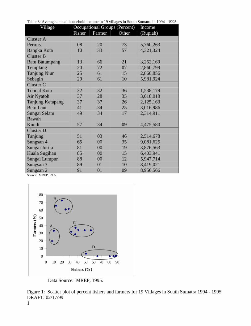
Table 6: Average annual household income in 19 villages in South Sumatra in 1994 - 1995.Village Occupational Groups (Percent) Income
Fisher Farmer Other (Rupiah)Cluster APermis 08 20 73 5,760,263Bangka Kota 10 33 57 4,321,324Cluster BBatu Batumpang 13 66 21 3,252,169Templang 20 72 07 2,860,799Tanjung Niur 25 61 15 2,860,856Sebagin 29 61 10 5,981,924Cluster CToboal Kota 32 32 36 1,538,179Air Nyatoh 37 28 35 3,018,018Tanjung Ketapang 37 37 26 2,125,163Belo Laut 41 34 25 3,016,986Sungai SelamBawah
49 34 17 2,314,911
Kundi 57 34 09 4,475,580Cluster DTanjung 51 03 46 2,514,678Sungsan 4 65 00 35 9,081,625Sungai Jurija 81 00 19 3,876,563Kuala Sugihan 85 00 15 6,403,941Sungai Lumpur 88 00 12 5,947,714Sungsan 3 89 01 10 8,419,021Sungsan 2 91 01 09 8,956,566Source: MREP, 1995.
0
10
20
30
40
50
60
70
80
0 10 20 30 40 50 60 70 80 90
Fishers (% )
Farm
ers (
%)
A
B
C
D
Data Source: MREP, 1995.
Figure 1: Scatter plot of percent fishers and farmers for 19 Villages in South Sumatra 1994 - 1995DRAFT: 02/17/991
A NEW DISCOVERED HOME FOR "OLD FOURLEGS": THE DISCOVERY OF AN INDONESIAN
POPULATION OF LIVING COELACANTHS
MARK V. ERDMANN Department of Integrative Biology - University of California, Berkeley
Berkeley, CA 94720 USA
DR. MOH. KASIM MOOSA Research and Development Center for Oceanology – Indonesian Institute of Sciences
ABSTRACT
uring the period of September 1997 through July 1998, two living coelacanth fishes were captured off the island of Manado Tua, North Sulawesi, almost 10,000 km from their only previously known home in the western Indian Ocean. A description of the events surrounding this discovery is presented along with a brief
review of the known biology of the living coelacanth Latimeria chalumnae, in order to provide background for Indonesian scientists interested in pursuing research on the Indonesian coelacanth. Recent analysis of mitochondrial DNA sequences from the preserved Indonesian specimen suggest that the Sulawesi population has been genetically isolated from the western Indian Ocean population(s) for millions of years and may actually represent an undescribed species of Latimeria. Future research priorities are outlined, and a review of the important measures taken to date to provide for the immediate conservation of this unique addition to Indonesia's natural heritage is given. Keywords: coelacanth, discovery, isolated, heritage
ABSTRAK Selama kurun waktu September 1997 sampai dengan Juli 1998, dua ikan coelacanth hidup tertangkap di lepas
perairan lepas pantai Pulau Manado Tua, Sulawesi Utara, kira-kira 10.000 km dari tempat asalnya di perairan Barat Samudera India. Sebuah gambaran dari kejadian-kejadian sekitar penemuan ini telah disajikan berupa uraian singkat mengenai biologi dari coelacanth hidup Latimeria chalumnae, dalam rangka memberikan latar belakang bagi peneliti-peneliti Indonesia yang tertarik untuk meneliti lebih lanjut mengenai spesies ini. Analisis baru-baru ini terhadap rangkaian DNA mitokondrial dari spesimen Indonesia awetan ini diperlihatkan bahwa populasi dari spesies yang berada di Sulawesi secara genetik diisolasi dari populasi induknya yang ada di perairan Barat Samudera India yang berumur jutaan tahun dan boleh jadi benar-benar perwakilan dari spesies Latimeria yang tak terdeskripsikan. Prioritas penelitian kemuka telah digariskan, dan sebuah telaahan terhadap pengukuran-pengukuran penting yang perlu dilakukan saat ini untuk menyediakan pelestarian secepatnya bagi warisan alam yang unik Indonesia. Kata-kata kunci: coelacanth, discovery, isolated, heritage INTRODUCTION
Until 1938, coelacanths were only known to a select few paleontologists as a strange order of lobe-finned fishes (Order Actinistia, Sub-class Sarcopterygii) which had appeared in the Devonian fossil record almost 370 million years ago and then seemed to go extinct about 80 million years ago near the end of the Cretaceous (Forey, 1990). This changed dramatically in early 1939 when newspapers around the world heralded the spectacular discovery of a "living fossil" coelacanth, trawled off the coast of
South Africa (Smith, 1939). The large blue fish, christened Latimeria chalumnae in honor of the type locality and the young curator who preserved it, was proclaimed by many the "zoological find of the century" (Thomson, 1991). The subsequent 14 year search for a second specimen of this peculiar fish, narrated in the classic book "Old Fourlegs" (Smith, 1956), resulted in the discovery of the "true" home of the living coelacanth in the Comoran archipelago in the western Indian Ocean.
D
Since that time, almost 200 specimens have been captured from the Comoros, and many have been preserved in museums around the world (Bruton and Coutouvidis, 1991). Study of these preserved specimens has provided a number of insights on the anatomy and physiology of L. chalumnae. The coelacanth, named from the Greek words meaning "hollow spine" (in reference to its hollow fin rays), has a number of unique morphological characteristics. Chief among these are its seven lobed fins, including the paired pelvic and pectoral fins, which bear superficial resemblance to walking appendages - hence its common nickname of "Old Fourlegs" (Smith, 1956). The fish is also unique in having a hollow, oil-filled notochord instead of a true backbone, a small secondary lobe on its tail (the epicaudal lobe), and an intracranial joint, which has been postulated to allow it a bigger gape for prey capture (Balon et al., 1988).
The coelacanth is a large fish, reaching almost 2 m in maximum length and weighing up to 100 kg (Bruton and Armstrong, 1991). Estimates of its maximum lifespan vary from 11 to at least 22 years (Balon et al., 1988). Like some sharks, L. chalumnae is ovoviviparous, with the female producing large (9 cm diameter) eggs which hatch in the uterus before she gives birth to up to 26 live young, which themselves may be up to 36 cm TL at birth (Heemstra and Greenwood, 1992).
The interesting mix of morphological characteristics displayed by the coelacanth has intrigued evolutionary scientists examining the relationship of this prehistoric fish to land animals. Based upon various lines of evidence, ranging from skeletal to genetic studies, the coelacanth is believed to be derived close to the base of tetrapod (four-legged land animals) evolution, along with the living lungfishes and the fossil rhipidistian fishes (Forey, 1998).
In 1987, a new era in coelacanth research began when Hans Fricke and colleagues began pioneering submersible studies of L. chalumnae in its native habitat in the Comoros (Fricke and Plante, 1988; Fricke et al., 1987). In situ studies on the coelacanth allowed unprecedented new observations on the ecology, behavior and locomotion of these mysterious animals. These
researchers quickly verified that the coelacanth is a slow-moving, nocturnal drift hunter which inhabits steep young volcanic slopes at typical depths of 150-300 m (Fricke et al., 1991). During the day, the fish shelter in lava caves in groups of up to fourteen animals, emerging at night to hunt small to medium-sized demersal fishes and cephalopods (Fricke et al., 1991; Uyeno and Tsutsumi, 1991). While they do not use their paired fins for support or locomotion upon the substrate, they do move these fins in an alternating manner which resembles a horse at a slow trot (Fricke et al., 1987). The observation that the fish are normally found below 150 m depth is apparently related to temperature requirements for optimal respiration; oxygen saturation of coelacanth blood is highest between 15-20(C (Hughes and Itazawa, 1972).
Fricke and colleagues also found that each individual coelacanth has a unique pattern of white flecks on its scales, making it possible to recognize individuals and therefore to reliably make population estimates (Fricke et al., 1991). Unfortunately, the most recent work on coelacanth population size suggests that L. chalumnae may now be in danger of extinction, only 60 years after its initial discovery. Population monitoring of L. chalumnae on Grande Comore island has revealed an apparent population decrease of 32% from 1991 to 1994 alone (Hissmann et al., 1998). This decline has been attributed primarily to overfishing by native artisanal fishermen, who occasionally catch the coelacanth as an incidental bycatch of their oilfish (Ruvettus pretiosus) fishery (Stobbs and Bruton, 1991; Fricke et al., 1995).
However, the underlying conservation problem is the (presumed) extremely limited distribution of the living coelacanth; until this year, established populations of L. chalumnae were only known from two islands in the Comoros (Hissman et al., 1998). The four known specimens caught from other localities (South Africa, Mozambique, and Madagascar) are all considered Astrays from the main Comoran populations, based upon mitochondrial DNA sequencing comparisons and the apparent unsuitability of the habitat at
these other locations (Schliewen et al., 1993; Bruton et al., 1992; Heemstra et al., 1996). The combination of extremely limited range and declining population size has qualified L. chalumnae for listing as both CITES Appendix 1 status and endangered status on the IUCN Red List of Threatened Animals, actions rarely taken for marine fishes (Vincent and Hall, 1996). SULAWESI SURPRISE
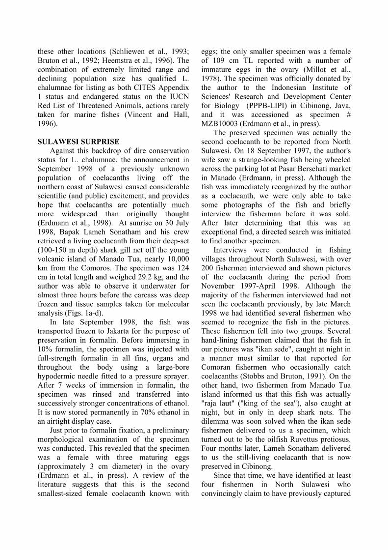
Against this backdrop of dire conservation status for L. chalumnae, the announcement in September 1998 of a previously unknown population of coelacanths living off the northern coast of Sulawesi caused considerable scientific (and public) excitement, and provides hope that coelacanths are potentially much more widespread than originally thought (Erdmann et al., 1998). At sunrise on 30 July 1998, Bapak Lameh Sonatham and his crew retrieved a living coelacanth from their deep-set (100-150 m depth) shark gill net off the young volcanic island of Manado Tua, nearly 10,000 km from the Comoros. The specimen was 124 cm in total length and weighed 29.2 kg, and the author was able to observe it underwater for almost three hours before the carcass was deep frozen and tissue samples taken for molecular analysis (Figs. 1a-d).
In late September 1998, the fish was transported frozen to Jakarta for the purpose of preservation in formalin. Before immersing in 10% formalin, the specimen was injected with full-strength formalin in all fins, organs and throughout the body using a large-bore hypodermic needle fitted to a pressure sprayer. After 7 weeks of immersion in formalin, the specimen was rinsed and transferred into successively stronger concentrations of ethanol. It is now stored permanently in 70% ethanol in an airtight display case.
Just prior to formalin fixation, a preliminary morphological examination of the specimen was conducted. This revealed that the specimen was a female with three maturing eggs (approximately 3 cm diameter) in the ovary (Erdmann et al., in press). A review of the literature suggests that this is the second smallest-sized female coelacanth known with
eggs; the only smaller specimen was a female of 109 cm TL reported with a number of immature eggs in the ovary (Millot et al., 1978). The specimen was officially donated by the author to the Indonesian Institute of Sciences' Research and Development Center for Biology (PPPB-LIPI) in Cibinong, Java, and it was accessioned as specimen # MZB10003 (Erdmann et al., in press).
The preserved specimen was actually the second coelacanth to be reported from North Sulawesi. On 18 September 1997, the author's wife saw a strange-looking fish being wheeled across the parking lot at Pasar Bersehati market in Manado (Erdmann, in press). Although the fish was immediately recognized by the author as a coelacanth, we were only able to take some photographs of the fish and briefly interview the fisherman before it was sold. After later determining that this was an exceptional find, a directed search was initiated to find another specimen.
Interviews were conducted in fishing villages throughout North Sulawesi, with over 200 fishermen interviewed and shown pictures of the coelacanth during the period from November 1997-April 1998. Although the majority of the fishermen interviewed had not seen the coelacanth previously, by late March 1998 we had identified several fishermen who seemed to recognize the fish in the pictures. These fishermen fell into two groups. Several hand-lining fishermen claimed that the fish in our pictures was "ikan sede", caught at night in a manner most similar to that reported for Comoran fishermen who occasionally catch coelacanths (Stobbs and Bruton, 1991). On the other hand, two fishermen from Manado Tua island informed us that this fish was actually "raja laut" ("king of the sea"), also caught at night, but in only in deep shark nets. The dilemma was soon solved when the ikan sede fishermen delivered to us a specimen, which turned out to be the oilfish Ruvettus pretiosus. Four months later, Lameh Sonatham delivered to us the still-living coelacanth that is now preserved in Cibinong.
Since that time, we have identified at least four fishermen in North Sulawesi who convincingly claim to have previously captured
coelacanths. Reports of varying reliability have also been received from people claiming to have witnessed coelacanths captured from other areas of Indonesia, including South Java and the Sangihe-Talaud islands above North Sulawesi. There appears to be strong evidence that at least one viable population of coelacanths exists in Indonesia, and possibly several. This immediately raises further questions: how large is the Indonesian population(s), and how closely related is it to the Comoran ones? Do further coelacanth populations exist in the vast area of ocean between Sulawesi and the Comoros? A NEW SPECIES?
One method of examining these questions is to determine the depth of divergence between the Sulawesi and Comoran populations using mitochondrial DNA sequence comparisons; evidence of recent gene flow between these two widely separated populations would be highly suggestive of intervening populations. Recently completed molecular analyses have revealed that a 3,221 base sequence obtained from the mitochondrial genome of the Sulawesi specimen is 3.4% divergent from the published sequence of an animal captured from the Comoros, indicating a likely depth of divergence of 5.5-7.5 million years (Holder et al., submitted).
In view of the substantial sequence divergence between the populations of coelacanths, it seems likely that the Indonesian population may represent a new and undescribed species of Latimeria. However, despite this substantial molecular sequence divergence, the preliminary morphological examination conducted at Cibinong and a limited morphometric comparison has shown that the Sulawesi specimen has a very similar allometry and overall external morphology to L. chalumnae (Erdmann et al., in press). This apparent contradiction is perhaps to be expected; the coelacanth lineage has shown surprisingly few morphological changes throughout its 360-million-year history, and Latimeria is remarkably similar to its nearest fossil relative Macropoma (Forey, 1990). A detailed morphological investigation of the
Sulawesi specimen is planned by PPPB-LIPI, Cibinong, in order to further explore the extent of morphological differences with Comoran specimens and the question of specific status for the Indonesian coelacanth.
With no fossil record of the age or original geographic range of Latimeria, it is difficult to postulate historical biogeographic explanations of the molecular divergence of these populations. It is possible that the massive tectonic changes which led to the formation of the Indo-Australian Arc and resultant separation of the Indian and Pacific Oceans caused a barrier to gene flow between these populations during the Miocene (Audley-Charles, 1991). The proposed Mindanao-Sulawesi land bridge, in conjunction with various proposed closures/constrictions of the Makassar Strait between Borneo and Sulawesi, may have resulted in isolation of a north Sulawesi coelacanth population in a Sulawesi/Sulu Sea basin during the Miocene and Pliocene (Hamilton, 1979; McManus, 1985). More recently, a combination of eustatic changes and possible tectonic movements may have resulted in constriction of the Makassar Strait during the late Pliocene and continuing through the Pleistocene (Audley-Charles, 1991).
FUTURE RESEARCH PRIORITIES
Research on the Indonesian coelacanths has only just begun, and there are many exciting avenues to be explored in this regard. Some will undoubtedly require collaboration with foreign scientists with previous expertise in coelacanth research, but there is considerable scope for individual research by interested Indonesian scientists. Research priorities at this time include detailed morphological and anatomical studies of the single preserved specimen, further characterization of habitat preferences and population size of the Manado Tua population, and exploration of promising additional sites within the archipelago which may be home to further coelacanth populations.
As mentioned previously, a very important priority at this time is detailed anatomical study of the preserved specimen in order to determine if it indeed represents a new species
of Latimeria. This research is already planned by the staff of PPPB-LIPI in Cibinong, and may include the collaboration of a foreign specialist in coelacanth taxonomy. However, there are many additional studies which should be undertaken with the preserved specimen, including stomach contents analysis, description of the immature eggs contained within the ovary, biochemical and genetic characterization of the specimen, and other possibilities. Numerous foreign scientists have already expressed interest in collaborating on such studies. While such collaboration is one alternative, this author strongly urges LIPI and associated scientific institutions in Indonesia to take full advantage of the opportunities presented by this specimen and encourage young Indonesian scientists to become involved in coelacanth study. Foreign collaborations can be beneficial in this regard, but only if there are Indonesian scientists who fully participate in the research and learn from the experience.
Further characterization of habitat preferences and population size of the Manado Tua coelacanth population is currently underway. Depth and temperature profiling are being conducted around Manado Tua using a transom-mounted sonar unit and continuous recording, substrate-attached Onset TidBit( temperature recorders. Preliminary results suggest that the slope angle at Manado Tua is similar to that reported for Grande Comore island (approximately 45(), while the thermocline at Manado Tua may be much less stable than that in the Comoros (Fricke et al., 1991; Erdmann, unpub.). Frequent cold-water upwelling in the area results in large temperature fluctuations of up to 7(C within a 30 minute period, and temperatures as low as 18.5(C have been recorded at only 40 m depth. This may allow coelacanths to penetrate relatively shallow waters of Manado Tua.
Unfortunately, more detailed habitat characterization and estimation of the size of the coelacanth population at Manado Tua is hampered by the typical depths at which coelacanths reside. Further work in this vein will require the use of either manned submersibles or remote-operated vehicles (ROV's) outfitted with video cameras and
capable of reaching 200-300 m depth. This will require foreign collaboration, as there are currently no such instruments available for use within Indonesia. Several foreign expeditions are currently planned, including one expedition involving LIPI scientists and Hans Fricke and his team using the submersible JAGO. The Fricke team is currently the only research group in the world with experience observing and filming coelacanths in situ, and it is hoped that this expedition will be successful in locating and documenting the Manado Tua population.
The possibility of additional coelacanth populations within Indonesia seems very likely; with over 17,000 islands and 81,000 km of coastline, the Indonesian archipelago is the worlds largest. More importantly, many of these islands appear to provide optimal coelacanth habitat - steep, young volcanic slopes which plunge into deep (1000 m+) water (Monk et al., 1997). Regions of Indonesia which seem particularly promising as candidates for further coelacanth populations include the southern coasts of Java and Sumatra, the Sangihe-Talaud islands to the north of Sulawesi, and the Inner Banda Arc in Maluku, stretching southwest from Banda to Wetar. A number of reports of previous coelacanth sightings in these areas have been received from interested anglers, divers, citizens and expatriates, and plans are being made to investigate these areas more thoroughly.
Exploration of these additional candidate areas will include at least two methodologies. One possibility is the use of fishing village surveys using photographs of the previously-captured specimens as well as educational posters and brochures that are planned for publication by LIPI. While such research is "low-tech" and relatively inexpensive, it suffers from the vagaries which plague interviews of fellow human beings. Furthermore, even in areas where coelacanths may exist, if the fishing communities do not use gears which sample the appropriate habitat (e.g., deep handlines or deep gill nets), negative results will invariably be obtained. Nonetheless, fisher surveys are a worthwhile means of preliminary
investigation of further candidate coelacanth sites.
The most direct means of exploring for further coelacanth populations is again the use of either manned submersibles or ROV's. Depending upon the results of the proposed JAGO mission to Manado Tua and further fisher surveys around Indonesia, it may be a worthwhile investment for the Indonesian scientific community to consider purchase or loan of either a submersible or an ROV in order to initiate an active phase of in situ coelacanth research in Indonesia.
CONSERVATION EFFORTS
In the meantime, it is extremely important for the Indonesian government, scientific community and environmental NGO network to continue and build upon early coelacanth conservation efforts. From the outset of coelacanth research in Indonesia, conservation of this unique aspect of Indonesia's natural heritage has been the foremost priority. The announcement of the discovery of the Sulawesi population was postponed until the finding was privately presented to LIPI and PHPA and the conservation implications thoroughly discussed within the Indonesian government. Only after the pertinent conservation and scientific authorities were aware of the importance of the find and of preventing exploitation of the coelacanth population was the announcement released to the journal Nature for publication. The date of publication was timed to coincide with President Habibie's visit to Manado to preside over the "International Year of the Oceans" activities. Within days, the discovery was covered in newspapers and magazines around the world and even on television on CNN and Reuters. Within Indonesia, media coverage in national and local newspapers, magazines and television has stressed the need for conservation of this new national treasure.
This engagement with local and national scientists, policy-makers and media representatives has been highly successful. At the national level, several meetings organized by LIPI have been held to discuss the finding amongst concerned agencies and plan a national
agenda for coelacanth research and conservation. Additionally, a ministerial decree declaring the coelacanth a national heritage which must be protected is now being considered by the Minister of Forestry and Agriculture. Also, the Convention on International Trade in Endangered Species (CITES) authority in Germany has contacted LIPI to discuss the possibility of extending Appendix 1 status of the living coelacanth from Latimeria chalumnae to the broader category of Latimeria spp., in order to extend protection to the potentially undescribed Indonesian species.
At the local level, the Bunaken National Park Authority (Balai Taman Nasional Bunaken) is well-informed on coelacanth conservation issues, as are dive operators and village policemen within the park. It is hoped that the Manado Tua coelacanth can act as a "keystone species" for the Bunaken National Park and provide a focus for improved coral reef management within the park. At least one local environmental NGO, Kelola, has begun a coelacanth education and conservation program for the villages within the park. This publicity and awareness has paid off; at least three attempts by foreign tourists/unofficial visitors to offer large rewards for further specimens have been reported by the local community and rejected by fishermen.
The likelihood of such incidents increasing in the future was a major reason for a recent meeting held in Manado in early February 1999. Sponsored by the Japanese development aid agency JICA, this meeting brought together representatives from LIPI, Universitas Sam Ratulangi, Dinas Perikanan (both national and provincial level), Balai Taman Nasional Bunaken, BAPPEDA and local and national environmental NGO's to discuss coelacanth conservation priorities. Results from that meeting include an acknowledgement that the greatest threat to coelacanth survival in North Sulawesi is not from artisanal fishermen who occasionally catch coelacanths as bycatch, but rather from potential directed efforts to capture coelacanths for either exotic animal collectors or scientific institutions, or for attempted display in
aquariums. It was strongly agreed upon that such efforts, especially to capture coelacanths for live display, must not be allowed unless substantial evidence can be compiled to show that such capture would not endanger the potentially small population here. While live display of captive coelacanths in the future may be potentially rewarding for both research and conservation purposes, all previous attempts at live capture of coelacanths have failed miserably, and such attempts should be forbidden until it is shown conclusively that living coelacanths are not in imminent danger of extinction.
Other results of the February meeting include plans for more detailed socioeconomic surveys of fishing villages within the Bunaken National Park. These surveys will further ascertain the incidence of coelacanth bycatch within the Park, the number and percentage of fishermen using gears likely to produce coelacanth bycatch, and the necessity and feasibility of banning gears which are likely to catch coelacanths and instead promoting alternative livelihood programs for displaced fishers. Additionally, representatives present at the meeting agreed on the need for a national poster campaign to both increase awareness of the Indonesian coelacanth and provide detailed instructions to fishermen on the importance of preserving bycatch specimens and contacting relevant authorities such as LIPI, Dinas Perikanan, or nearby PHPA offices such as Balai Taman Nasional Bunaken. Poster design is currently being considered, and funding from JICA will be sought to cover production costs.
The discovery of an Indonesian population of living coelacanths provides hope that conservation prospects for this magnificent fish are now considerably brighter. At the same time, it brings with it an important responsibility for the Indonesian people to act as wardens of this unique aspect of both Indonesia's and the world's natural heritage. The eyes of the international conservation community are now focused on Indonesia, and we must accept full responsibility for careful stewardship of the Indonesian coelacanth.
ACKNOWLEDGEMENTS We would like to gratefully acknowledge
the sponsorship and support of the Indonesian Institute of Sciences and the financial support of the U.S. National Science Foundation (International Programs Grant #INT-9704616) and the National Geographic Society (Grant #6349-98). The staff of PPPB LIPI have been most accommodating and enthusiastic, especially A. Tjakrawidjaja, Y. Suhardjono, I. Rachmatika, S. Wirjoatmodjo, R. Hadiaty, Pak Koestoto, and Ibu Siti Prijono. S. Jewett and the Smithsonian Institution provided financial and logistical help in preserving the specimen and arranging CITES export permits for tissue export. Additionally, Pak Subiyanto from PHPA was invaluable in arranging the CITES permit. A. Mehta-Erdmann provided valuable comments on the manuscript. I would also like to express gratitude to the Onset Computer Corporation for donation of TidBit( temperature recorders for use in this research. Finally, thanks very much to Om Lameh Sonatham and his crew for delivering to the world the first preserved Indonesian coelacanth. REFERENCES Audley-Charles, M.G. 1991. Geological
history of the region of Wallaces line. In: Whitmore TC (Ed). Wallaces line and plate tectonics. Clarendon, Oxford. pp 24-35.
Balon, E.K., Bruton, M.N. and H. Fricke.
1988. A fiftieth anniversary reflection on the living coelacanth, Latimeria chalumnae: some new interpretations of its natural history and conservation status. Environmental Biology of Fishes. 23:241-280.
Bruton, M. and M.J. Armstrong. 1991. The
demography of the coelacanth Latimeria chalumnae. Environmental Biology of Fishes. 32: 301-311.
Bruton, M., Cabral, A.J., and H. Fricke. 1992.
First capture of a coelacanth, Latimeria
chalumnae, off Mozambique. South African Journal of Science. 88:225-227.
Bruton, M. and S.E. Coutouvidis. 1991. An
inventory of all known specimens of the coelacanth Latimeria chalumnae, with comments on trends in catches. Environmental Biology of Fishes. 32: 371-390.
Erdmann, M.V. In press. An account of the first
living coelacanth known to scientists from Indonesian waters. Environmental Biology of Fishes.
Erdmann, M.V., Caldwell, R.L., and M.K
Moosa. 1998. Indonesian King of the sea discovered. Nature.395: 335.
Erdmann, M.V., Caldwell, R.L., Jewett, S.L.
and A. Tjakrawidjaja. In press. The second recorded living coelacanth from North Sulawesi. Environmental Biology of Fishes.
Forey, P.L. 1990. The coelacanth fish: progress
and prospects. Sci. Progress Oxford. 74:53-67 (1990).
Forey, P.L. 1998. History of the coelacanth
fishes. Chapman and Hall, London. Fricke, H., Hissmann, K., Schauer, J. and R.
Plante 1995. Yet more danger for coelacanths. Nature. 374:314.
Fricke, H., Hissmann, K., Schauer, J., Reinicke,
O., Kasang, L. and R. Plante. 1991. Habitat and population size of the coelacanth Latimeria chalumnae at Grand Comoro. Environmental Biology of Fishes. 32:287-300.
Fricke, H. and R. Plante. 1988. Habitat
requirements of the living coelacanth Latimeria chalumnae at Grande Comore, Indian Ocean. Naturwissenschaften. 75:149-151.
Fricke, H., Reinicke, O., Hofer, H. and W.
Nachtigall. 1987. Locomotion of the
coelacanth Latimeria chalumnae in its natural environment. Nature. 329:331-333.
Gordon, A.L. 1998. Coelacanth populations
may go with the flow. Nature 395:634. Hamilton, W. 1979. Tectonics of the
Indonesian region. U.S. Geological Survey Professional Paper 1078. Washington, DC.
Heemstra, P.C., Freeman, A.L, Wong, H.Y.,
Hensley, D.A. and H.D. Rabesandratana. 1996. First authentic capture of a coelacanth, Latimeria chalumnae, off Madagascar. South African Journal of Science. 92:150-151.
Heemstra, P.C. and P.H. Greenwood. 1992.
New observations on the visceral anatomy of the late-term fetuses of the living coelacanth fish and the oophagy controversy. Proceedings of the Royal Society of London B. 249:49-55.
Hissmann, K., Fricke, H. and J. Schauer. 1998.
Population monitoring of the coelacanth (Latimeria chalumnae). Conservation Biology. 12:759-765.
Holder, M.T., Erdmann, M.V., Caldwell, R.L.
and D. Hillis. Two species of living coelacanth? Submitted to Nature, January 1999. (Submitted)
Hughes, G.M. and Y. Itazawa. 1972. The effect
of temperature on the respiratory function of coelacanth blood. Experientia 28:1247.
Millot, J., J. Anthony and D. Robineau. 1978.
Anatomie de Latimeria chalumnae, Tome III. Editions du Centre National de la Recherche Scientifique, Paris p. 48.
McManus, J.W. 1985. Marine speciation,
tectonics, and sea-level changes in Southeast Asia. Proceedings of 5th International Coral Reef Symposium. 4:133-138.
Monk, K.A., De Fretes, Y. and G.R. Lilley. 1997. The ecology of Nusa Tenggara and Maluku. Periplus, Singapore.
Schliewen, U., Fricke, H., Schartl, M, Epplen,
J.T. and S. Pääbo. 1993. Which home for coelacanths? Nature. 363:405.
Smith, J.L.B. 1939. A living fish of the
Mesozoic type. Nature 143:455-456. Smith, J.L.B. 1956. Old Fourlegs: the story of
the coelacanth. Longmans, Green and Co., London.
Stobbs, R.E. and M.N. Bruton. 1991. The
fishery of the Comoros, with comments on
its possible impact on coelacanth survival. Environmental Biology of Fishes. 32:3431-359.
Thomson, K.S. 1991. Living fossil: the story of
the coelacanth. Norton, New York. Uyeno, T. and T. Tsutsumi. 1991. Stomach
contents of Latimeria chalumnae and further notes on its feeding habits. Environmental Biology of Fishes. 32:275-279.
Vincent, A.C. and H.J. Hall. 1996. The
threatened status of marine fishes. Trends in Ecology and Evolution. 11:360-361.

Combatting Destructive Fishing Practices in Komodo National Park:Ban the Hookah Compressor!
ABSTRACT
In efforts to quantify and combat destructive fishing practices in Komodo National Park, The Nature Conservancyhas learned that patterns of marine resource use are complex. While patrols have successfully decreased the incidenceof large-scale dynamite and cyanide fishing, considerable further protection is needed before the Park is truly a MarineReserve. Currently, live reef fish have priority for places on the airplane out of Labuan Bajo, while visitors who cometo see the Komodo dragon and the world's richest coral and fish life must take a 12-hour ferry! The demersal fishstocks and coral reefs, which have suffered considerable damage already, continue to be threatened by a variety ofdestructive methods, including the use of hookah compressors, reef gleaning, fish traps, gillnets, and bottom lines. Inparticular, banning the use of hookah compressors, which are used in both dynamite and cyanide fishing, isrecommended. On paper, legislation protects all animals, plants, and habitats within the National Park, yet ParkAuthorities and Police Officers are not aware of the destructive impact of commonly practised fishing methods likecompressor fishing, reef gleaning and 'bubu' trap fishing.
ABSTRAK
Dalam rangka mengukur besarnya akibat dan memberantas praktek-praktek penangkapan ikan yang bersifatmerusak lingkungan di kawasan Taman Nasional Komodo, The Nature Conservancy menemukan/mendapatkan bahwapola pemanfaatan sumberdaya alam ternyata kompleks sekali. Walaupun patroli laut telah sangat berhasil dalammenurunkan jumlah kegiatan penangkapan ikan skala besar dengan bahan peledak dan racun sianida, namunperlindungan lebih lanjut sangat dibutuhkan sebelum taman nasional ini dapat sungguh-sungguh menjadi Taman SuakaKelautan. Pada saat sekarang pengiriman ikan karang dalam keadaan hidup memperoleh prioritas dalam pemakaianruangan di pesawat terbang yang keluar dari Labuan Bajo, sedangkan pengunjung dan wisatawan yang berdatanganuntuk melihat Komodo dan kehidupan ikan dan terumbu karang yang paling kaya di dunia haruslah menggunakanperahu penyebrangan (ferry) yang memakan waktu 12 jam. Sementara itu, stok ikan demersal dan terumbu karangyang telah cukup banyak mengalami kerusakan, tetap terus terancam kelestariannya oleh aneka ragam carapenangkapan yang tidak akrab lingkungan, termasuk penggunaan kompresor "hookah", pencukilan karang, bubu danjaring insang serta pancing dasar secara khusus, pelarangan penggunaan kompresor "hookah", yang digunakan baikpenangkapan dengan bahan peledak dan racun sianida (potas), sungguh direkomendasikan. Di atas kertas, hukum(undang-undang dan peraturan telah melindungi segala jenis satwa, tanaman dan habitat yang berada dalam tamannasional. Namun, otoritas taman dan petugas kepolisian tidaklah selalu waspada akan akibat buruk dari cara-carapenangkapan yang sekarang ini lazim dikerjakan disana, seperti halnya dengan kompresor, pencukilan karang danpemakaian jerat atau bubu.
1. Komodo National Park
Komodo National Park (KNP, Figure 1) is located between the islands of Sumbawa andFlores in Indonesia. The Park was established in 1980, and has a management unit with 88 staff.The Park was declared a Man and Biosphere Reserve and a World Heritage Site in 1986. KNPincludes three major islands, Komodo, Rinca and Padar, and numerous smaller islands togethertotalling 41.000 ha of land. KNP is famous as the habitat of the Komodo dragon, Varanuskomodoensis, but it is also one of the richest areas for coral biodiversity in Indonesia, and has oneof the richest fish faunas in the world with an estimated 1.000 species. The Park contains 132.000ha of marine waters, with a high diversity of habitats including coral reefs, rocky shores, sea grassbeds, sandy bays and mangroves.
2
There are presently some 2.300 inhabitants living within the Park, spread out over 3settlements (Komodo, Rinca and Kerora). An estimated 15.000 people live in fishing villagesdirectly surrounding the Park. Park inhabitants mainly derive their income from a pelagic lift net('bagan') fishery (95% of their yield comes from this geartype) which is targeting squid and smallschooling pelagic fish. Additional income and food is derived from reef gleaning ('meting'), amethod whereby corals are destroyed in search of marine invertebrates. Non-inhabitant fishermenuse pelagic lift nets and a variety of other geartypes in KNP waters. Although the pelagic lift netforms the most important geartype in KNP in terms of yield, other fishing methods form a majorthreat to the Park's marine resources. Destructive fishing practices such as dynamite and cyanidefishing (with the use of hookah compressors), reef gleaning and local overfishing destroy both thehabitat and the targeted resource itself (fish and invertebrate stocks).
2. A Management Plan for the marine component of Komodo National Park
Upon request from the Ministry of Forestry, The Nature Conservancy (TNC) is assisting theNational Park's authority with the management of the marine component of the Park. In October1996, a draft management plan was completed for the marine component of KNP. The objective ofthe Park management is "To protect the demersal and sedentary marine life forms of KomodoNational Park, their ecosystems and their habitats, and to maintain the natural population andcommunity structures of these life forms". Key modules in the management plan are:I. Design of a marine park zonation plan and specification of regulations.II. Implementation of a cross-sectoral enforcement program with Park Authorities, Police, Army,
Fisheries Service, Local Government and Communities.III. Involvement of local communities through: 1) community awareness programs, 2)
participatory planning, and 3) establishment of a local NGO.IV. Building of partnerships with private enterprise to develop alternative livelihoods in a variety
of compatible enterprises such as: eco-tourism, mariculture and fisheries for large coastalpelagic species.
V. Implementation of an environmental mooring buoy program to prevent anchor damage fromboats bringing tourist to popular snorkelling and diving sites.
VI. Implementation of a comprehensive monitoring and research program to evaluate managementmeasures and suggest the most desirable and effective interventions. The monitoring andresearch program includes the following sub-modules:a. monitoring of the status of the coral reefs,b. monitoring of the status of commercially targeted fish populations and their spawning
aggregation sites,c. monitoring of fisheries resource utilization patterns,d. applied research and monitoring of the sustainability of proposed compatible enterprises
(alternative livelihoods), ande. applied research and monitoring of the effectiveness of different methods to enhance coral
reef rehabilitation.The present paper focuses on the results from monitoring programs and on the need for
effective law enforcement. This focus does not imply that other program modules are lessimportant, on the contrary, it is our strong belief that the Park management will only achieve theirgoals by implementing a comprehensive program in which community involvement and alternative
3
livelihood strategies are very important modules. These other two modules will therefore bediscussed in separate papers.
3. Present status of the resource and patterns in resource utilization3.1. The Coral Reefs
The coral reef monitoring program covers 185 sites which are all surveyed every two years andat 3 different depths. Averages over 25 square mile areas of the Park are used to estimate theoverall status of the coral reefs (Figure 2). Results of the 1996 monitoring round show that seriousdamage has occurred in most areas inside and outside the Park. The most heavily affected areasinside the Park are found in areas bordering the bufferzone in the northeastern region of the Park,namely the reefs off northeast Komodo, north Padar and north and east Rinca. In all these areas65% or more of the hard coral was dead in 1996. The least damage (less than 45% mortality)occurs in the southwestern and southern areas of the Park, with some healthy (hard coral) reefsfound especially in the south Komodo and south Padar regions. A few locations in the far northeastof Komodo also remain in good condition. The amount of damage generally increases from southto north and from west to east. Most fishing communities have their settlements on the northeasternside of the Park, except for Sape which is on the west side of the Park.
3.2 Fish Spawning Aggregation Sites
By monitoring the size frequencies of a number of commercially targeted fish species on anumber of known aggregation sites, it will be possible to evaluate developments in the fishpopulations in a cost-effective manner. By identifying mass spawning sites for important fishspecies it will be possible to select areas which need special protection. Preliminary results showthat a number of aggregation and spawning sites have been positively identified in the northeasternand southeastern areas of Komodo. Spawning aggregations of four species of grouper and ofnapoleon wrasse were observed to occur in these areas around the month of October. The spawningaggregation sites contain concentrations of these species during all months of the year. Many morefish spawning aggregation sites are thought to exist within the borders of Komodo National Parkand additional site surveys will be conducted in October 1998.
3.3 Patterns in Marine Resource Utilization
A routine patrolling and enforcement program started on 28 May 1996, with the intention tohave 2-day patrols covering the entire park area on a weekly basis, and to investigate all capturefisheries activities encountered. The number of incidents of dynamite and cyanide fishing droppedsignificantly during the first period of intensive patrolling in 1996. A reduction of more than 75%was recorded for dynamite incidents, and several arrests were made of fishermen using destructivefishing methods in and around the Park.
Members of the enforcement team have been trained to record data on resource utilizationpatterns during routine patrols in the KNP area. This data includes number, type and origin offishing crafts, their catches and their distribution in space and time. Each non-bagan (non lift net)fishing vessel or fishing group encountered during the routine patrols is investigated. Bagan areexcluded since they form a separate type of pelagic fishery which is not considered threatening tothe demersal and sedentary marine resources of Komodo National Park. Bagan boats are
4
investigated when they engage in non-bagan activities. The objective of this monitoring program isto determine who is doing what, where and when in the Park. The data base on resource utilizationpatterns shows Park Managers which community groups are involved in which fishing activities,where they fish, and when they fish. Over time this data will also show any changes in thebehaviour of fishermen due to management measures and it will indicate which groups offishermen or areas in the Park may need extra attention.
Non-bagan fishing effort in the park ranges from less than 300 boats per 25 square miles peryear in the south to more than 1000 boats per 25 square miles per year off the coast of northeastKomodo (Figure 3). The area with the highest fishing effort is also the area with the highest coralmortality. Areas with low coral mortality are typically those areas where fishing effort is low,(Figure 4) although high coral mortality is also found in a few areas where fishing effort isrelatively low. There are no areas where fishing effort is high and coral mortality low. It is alsoclear that fishing effort is relatively high in areas where fish spawning aggregation sites are locatedand fishing therefore forms a direct threat to the fish species aggregating at these sites.
Communities in the Park, the villages of Komodo, Rinca and Kerora, represent only 21% ofthe non-bagan fishing effort in the Park. Communities directly surrounding the Park (Mesa,Papagarang, Labuan Bajo and Warloka) represent 36%, communities from Sape (east Sumbawa)represent 29% and outsiders from further away represent 14% of the effort. Fishermen fromKomodo and Rinca are involved in reef gleaning (Figure 5), those from outside the Park mainly inbottom hook and line fishing, gillnetting, compressor and 'bubu' trap fishing.
Most geartypes are specifically yielding single yield categories except for 'compressor' and'reef gleaning' (Figure 6). The latter two geartypes typically yield a widely varied catch, rangingfrom live fish and lobster (often caught with cyanide) to sea cucumber, shellfish (mostly abaloneand pearl oyster), coral and seaweed. These two geartypes or methods form major threats to themarine ecosystem of Komodo National Park. It should be noted here that dynamite and cyanidefishermen (at least the larger operations) always use compressors to bring divers down and tocollect their catch.
Non-destructive and low-impact methods such as pelagic hook and line together account foronly 18%, whereas the highly destructive methods of reef gleaning, compressor fishing, trap fishingand 'other methods' (including bomb and cyanide fishing) together account for 34% of the totalnon-bagan effort. The most common geartypes used in the park, are bottom hook and line andgillnets. These geartypes together account for 48% of total effort in the Park. These geartypes areforming direct threats for the sedentary fish stocks in the Park, especially when they are used inareas where fish are aggregating to spawn. Large amounts of spilled nylon fishing line wereencountered at fish spawning aggregation sites and certain species like square tail coral trout(Plectropomus aerolatus), which aggregate on shallow coral reefs, are decimated on these sites.
It is estimated that around 1.000 tons of fish, lobster, shrimp, pearl oyster and abalone wereharvested from Komodo National Park in 1997. In comparison, this is about the same amount inweight as the bagan (lift net) yield from Park inhabitants (Komodo and Rinca) alone. It is importantto realize that non-bagan yields represent only 5% in terms of weight of the total yield (bagan +non-bagan) landed by Park inhabitants. Fishermen from Komodo comment that non-baganactivities are still important to them since the bagan fishery is exploited by middlemen which leavevery little of the profits for local fishermen. Freeing the fishermen from the claws of thesemiddlemen, and helping them to gain higher profits from their bagan activities may be an importantstrategy to keep them from destroying the reefs.
5
4. Destructive Fishing Methods and Law Enforcement
Although the frequency of dynamite fishing in the Park has been low during recent years,destructive fishing practices and local overfishing remain a constant threat to the Park's sedentarymarine ecosystems. We can really not speak of a 'Marine Reserve' when harvesting and destructionof marine life is taking place at a rate as presently is the case in Komodo National Park. We have along way to go before the KNP waters will be a marine reserve where all living creatures and theirhabitats are fully protected. The local Fisheries Service, for example, feels that the KNP waters arefishing grounds where yields have to be maximized. Park Managers, however, comment thatlegislation is already in place to protect all animals, plants and their habitats within National Parksin Indonesia. Enforcement of this legislation, however, has not been implemented. Supportingmaterials from outside sources would help to convince the Park authorities of the need of a ban onhookah compressors. The protection of the marine environment in KNP has to be taken seriouslyand the following phases of increasingly strict law enforcement need to be implemented.I. Remove of all large-scale dynamite and cyanide fisheries from within the Park's borders.
Large-scale dynamite operations work with big boats and dive crews in canoes with hookahcompressors. Large-scale cyanide operations consist of motherships with several work-boatswith hookah compressors.
II. Combat large-scale dynamite and cyanide fishing in the bufferzone (northeast of KNP) andfurther outside the park.
III. Remove of small-scale dynamite and cyanide fisheries (with compressors in small boats) fromwithin the Park's borders.
IV. Combat small-scale dynamite and cyanide fishing in the bufferzone and other areas directlyadjacent to the Park.
V. Prohibit of key destructive geartypes from within the Park's borders. The most urgent needhere is to ban the hookah compressor.
VI. Close the Park for demersal geartypes like gillnets and bottom hook and line. Only by banningthe widespread use of gillnets and bottom hook and line from the Park, starting with a closureof fish spawning aggregation sites, can sedentary fish stocks truly be protected. Exceptions willhave to made for Park inhabitants.
VII. Establish of multiple-use zones near settlements in the Park, where inhabitant fishermen haveexclusive fishing rights to use demersal geartypes. The Park waters should remain open forpelagic fisheries, preferably with exclusive fishing rights for Park inhabitants and neighbouringcommunities.
In the section below, the different phases are discussed and examples are given to highlight thespecific problems which are encountered while trying to achieve the goals.
I. Remove large-scale dynamite and cyanide fisheries from KNP waters
The first objective is the most easy to achieve once a routine patrolling program has beeninstalled. Large-scale operations, run by outside fishermen, are simple to identify and have in factbeen reduced by more than 80% from Komodo National Park. Serious confrontations took placeespecially in 1996 after which the message was clear and this type of operations became rare insidethe Park. Live-aboard dive vessels still occasionally report bombing in remote corners of the Parkand these are sometimes larger operations. If reports come in time, a patrol can be sent out and thebombers can usually be arrested. Large-scale cyanide fishing for aquarium fish is still occasionally
6
encountered and is difficult to prosecute. Boats from east Java have been chased out of the Park onvarious occasions but Police and Park wardens seemed unwilling to make arrests, supposedly sinceex-military personnel are present on these boats.
Example. On one recent occasion our monitoring crew reports 2 large boats (15 and 20 GT)inside the Park, off northeast Komodo. Judging from their model these boats are from Banyuwangior Madura (east Java), and they are using hookah compressors, probably fishing for aquarium fishwith cyanide. We receive the report at 15.00 pm, immediately inform the Park authorities and thePolice and are told to keep one speedboat standing by. We suggest sending 2 speedboatsimmediately. The next morning the KNP authorities and the Police send some people to go outafter the cyanide boat, using one of our speedboats. The enforcement team reports later that theyfound the cyanide boats that morning. They were from Banyuwangi and they were fishing withcyanide for aquarium fish. One man is arrested and our speedboat driver finds some 8 to 10 litres ofcyanide solution which is taken in as evidence. One person is arrested and placed in the speedboat.According to our boat driver the Police officers wanted to let the boats go right away, but the KNPstaff did not agree. After that, the enforcement team orders the cyanide boats to go to Labuan Bajoimmediately. They do not put any guards on the boats and they do not follow them either. Insteadthey go in to a Park ranger station on Komodo Island to have their lunch. When they finally go toLabuan Bajo, the cyanide boats are obviously not there. The arrested person, who is still on thespeedboat, is ex-Navy and he would later be released because of "lack of evidence". This is anexample where competence and bonafide leadership were clearly lacking in the enforcement team.Since late 1997 TNC has hired a pensioned Chief of Police from the region, who has an excellentpatrolling record and who is joining on all patrols since early 1988. A successful arrest of a large-scale cyanide operation was made outside the Park under the leadership of this ex-policeman.
II. Combat the large-scale dynamite and cyanide fisheries in the bufferzone and other areasoutside the Park.
Our present strategy is to combat the large-scale destructive fisheries as soon as they enter thePark bufferzone or other waters in the immediate Park surroundings. The minimum objective ofthis strategy is to make these operations leave the area before they enter the National Park, themaximum objective is to have these operations prosecuted as an example and warning to otheroperations. Unfortunately National Park staff are not allowed to patrol outside the Park under theirpresent leadership but fortunately the local Police has recently obtained "Water Police" status,which means they can and should react immediately to any report of illegal activity in the waters ofKomodo District. In practice this means that any suspected activity outside the Park can now bechecked by calling the Police who will normally send two constables with us in our speedboat toinvestigate the activity. In 1997 this strategy led to violent clashes with outside large-scaledynamite fishermen who tried to throw bombs in the speedboats but who were answered with gunfire. Although actual arrests are difficult and dangerous, usually these boats do not return after thistype of engagement. In case of one serious clash, the crew of a dynamite boat was arrested inMaumere Hospital, on the north coast of Flores Island, where they reported in with several shotwounds. Fortunately nobody was killed.
Fish bombing at a larger-scale still takes place at Gili Banta, north west of Komodo, by boatsfrom Sape (east Sumbawa). This island is too far for intervention from Labuan Bajo and belongs tothe Nusa Tenggara Barat (NTB) Province, where Police from Labuan Bajo have no jurisdiction.Nothing can be done here from our side. In February 1996, Banta Island was recommended for
7
addition to KNP and NTB provincial authorities pledged commitment to protect the Island. Nothinghappened after that.
No fewer than 7 large cyanide boats (fishing for aquarium fish) from Banyuwangi have beenspotted working in and just outside the bufferzone, north of KNP, in December 1997. Most of themwere checked by the police and cyanide was found on all occasions. Still, these boats were onlychased away and not a single person was apprehended. The district Chief of Police was presentwhen one of these boats was investigated. Most of these boats seemed to have ex-Army or ex-Navypersonnel on board. We have to have our own strong leadership on the patrol boats to make surethat arrests are made.
Late December 1997, four "Hong-Kong-type" metal dinghies (blue and red) with modernoutboard engines, compressors and well-equipped dive crews were working around the northwestern tip of Flores Island. Most likely a cyanide operation which was based on a mothership,although we couldn't locate that vessel. This case was reported to the Fisheries Service who did notreact. We decided to see if we could locate the mothership, and found it a few days later (theoperation had moved east), with the same dinghies working nearby. Again they were diving and wesuspected cyanide fishing for live reef food fish. In Labuan Bajo we reported to Police andFisheries and we went out with two speedboats.
We apprehended the mothership and five speedboats equipped with professional gear. Thedivers were surprised and asked us what was going on since their boss had already "talked to theauthorities". Four of the dinghies were equipped for diving and working when we arrested them.One dinghy seemed to be on stand by. The divers were using Technisub dive suits, modernregulators and well maintained hookah compressors. All dinghies had brand new Yamaha outboardengines. Each dinghy had two divers and two helpers in the boat. We came in at very high speed tominimize their time for reaction. When we approached the speedboats, the divers were justsurfacing and they threw several plastic squirt bottles in the water which we were able to recover.On all speedboats and on the mothership we found many squirt bottles with unknown content.
The divers had caught groupers (flowery cod, E. fuscoguttatus), barramundi cod, coral trout (P.leopardus), lobsters and napoleon wrasse. One napoleon wrasse must have weighed more than 25kg. One dinghy had caught 13 large flowery cod in a few hours and from the look of this catch wesuspected they were in the process of cleaning out a spawning aggregation. Each dinghy had asmall reservoir build next to the live fish well, where they were mixing a solution of sea water withSunlight soap bars and possibly other substances (cyanide). We do not know what the soap is forbut we have thought of a few options:
1. The soap actually increases the effectiveness of the cyanide solution2. The soap keeps the cyanide in solution3. The soap forms a white cloud underwater, showing where the solution is and facilitating
manipulation4. Decoy
We do not know which, if any of these, is the answer. If this practice has been observed earlierand/or if it is known why the soap is used, we would very much hope to hear the answer to thisquestion.
On the mothership we found several bottles with a solution showing white powder (but nosoap). We suspect this to be cyanide. The concentration in these bottles seemed to be high since thepowder was not dissolving. On the mothership there was a large box with sunlight soap bars. Intotal there were 8 hookah compressors (4 on the mothership and one in each dinghy). Themothership had a large well-maintained inboard engine and two auxiliary Yamaha outboard
8
engines. The mothership could work with 8 divers in the water and each dinghy with 2 divers. It isabout 25 meters long and has several large live fish wells. There were 23 crew in total and all werebrought to Labuan Bajo where they are being processed by the police.
The captain showed some letters, with signatures from the local Fisheries Service and otherlocal government officials which would allow this boat to fish with "hook and line" and "traps". Nogear of this kind was found on any of the boats and the letters were not official licences but "locallyarranged papers". The crew told us that their boss was called Arifin, from Kendari, Sulawesi, andthis person would be staying at the house of Pak Haji Idris (a local live fish trader) in Labuan Bajo.Rumours are, that the whole operation is actually financed by a Korean person who is using Arifinas a straw man. We have agreed with the local head of police that we will supply travel money forone policeman to bring the evidence to the Criminal Laboratory in Jakarta.
We have also obtained several bottles (which were not recorded as evidence) which we hadanalysed separately to enable cross-checking of results. One set of five bottles was send to VaughnPratt at the International Marinelife Alliance (IMA) and these samples tested positive for cyanide.A second set was send to PT Sucofindo in Jakarta and these also tested positive with reportedresults for cyanide concentration:"Sample 1" : 762.50 mg/l"Sample 2" : 1251.00 mg/l (with soap)"Sample 3" : 2017.50 mg/l"Sample 4" : 2.30 mg/l (with soap)"Sample 5" : 1401.00 mg/l"Sample 4" was filled out of the reservoir in the dinghy, into a used squirt bottle. This resultsuggest that the cyanide was not yet mixed in that reservoir. The low concentration was probablyleft over cyanide from the used bottle.
In the meantime the local Fisheries Service has reported to its upper echelons that the arrestedfishermen were using just soap to catch fish and that there was no cyanide. The boat is still beingheld because it didn't have all the right papers but the rumours are that this will be "fixed" beforethe trial starts. The police sent one constable to the criminal laboratory only after 3 weeks and whenwe checked the evidence they were bringing, it was clear that "unsoaped" cyanide solution haddisappeared. Some of the "soaped" solution was still there and we still have hope that themanipulation of evidence has been insufficient. There is a good chance though, that the criminallaboratory will not find any cyanide.
We are confident though that our 'minimum objective' will be achieved, and that this operationwill leave the area before ever having entered the waters of Komodo National Park. The fishermenon this operation will hopefully also bring the message back home in the case they do not end up injail.
III. Remove the small-scale dynamite and cyanide fisheries from the Park
Although the small-scale dynamite fishery is no longer a very large threat inside the Park,small-scale cyanide fishing by surrounding communities remains a major problem. Many boatsfrom the Pulau Mesa and Sape communities are fishing with compressors inside the Park and patroldata show that they normally catch lobster and live reef fish (mostly barramundi cod). Many of thecompressor fishermen are using cyanide but this is difficult to prove. They keep their cyanidecontainers connected to large stones which are dropped overboard as soon as they see the patrolboat. No cyanide is found when these boats are searched and it is picked up by the divers after the
9
patrol has left. These type of small-scale cyanide operations can only be stopped by banning the useof hookah compressors.
Inspection of holding cages outside the Park (where these boats are landing their catch) showedlarge numbers of napoleon wrasse, barramundi cod, groupers and coral trout. Fishermen who wereinterviewed upon landing admitted the use of cyanide in front of Police, Fisheries, Park authoritiesand the press, but nothing was done. Although the trade in napoleon wrasse is prohibited without aspecial licence, this means nothing in practice since local traders, who do not have any licence, canapparently continue even after serious complaints in the press. Local government officials do notseem to have any incentives to make problems for the live reef fish trade (on the contrary, wewould have to conclude). Live fish fly out of Labuan Bajo to Bali every day and in the small planetake priority over tourists, who are refused and have to take an old ferry to Sumbawa. The supply ofoxygen for these live fish transports is larger then the one available for recreational SCUBA-divingemergencies.
IV. Combat the small-scale dynamite and cyanide fisheries in the Park's bufferzone and inother areas surrounding the Park.
Small-scale bombing and cyanide fishing is still a problem in areas just outside the park and isvery difficult to combat. Our strategy is to invest in intensive interaction with communities. Arrestswill be engineered when certain groups are becoming a clear problem, but rather than pushingcriminal charges, communication is the key after arrests. We try to involve small-scale fishbombers in our community work or in alternative livelihood projects after they have been arrested.Their communities will also receive extra attention in terms of awareness programs andsurveillance. An example of combatting small-scale fish bombing is described below.
October 1997. Suspected fish bombing on reefs north of the Park's bufferzone, by boats withmodels as from Palue Island (north Flores). The boats seemed to be based in the area aroundLabuan Bajo since this is where they were sailing to and from. Many fishermen with boats of the"Palue model" are camping at a beach on Bajo Island, near Labuan Bajo. Fishermen from LabuanBajo complain that these people are bombing the reefs where they normally fish with hand lines.They report that the Palue people are selling fish from fish bombing every day at Pulau Mesa. InNovember fish bombing is observed on a reef not far from Labuan Bajo. We observe a small greenboat of the Palue model. Many dead fish are floating around while that boat returns in direction ofBajo Island near Labuan Bajo.
We find out that there is a settlement of Palue origin near Labuan Bajo in an area called"Nangenae". These people keep strong connections with their "home island", work together withfish bombers from that island and are notorious dynamite fishermen themselves. This communityhas now become the focus of our attention and the Police are also starting to collect information intheir village.
In December our fish monitoring team reports a dynamite fishing operation at work at KanawaIsland, north of the Park's bufferzone. A small boat of the Palue type is at work and this boat isprobably from the Nangenae settlement. We decide to organize an arrest and go out in the companyof two policemen. A successful arrest is made of a 'Palue' fisherman from Nangenae. The fishermanconfesses quickly and we confiscate around 200 kg of dynamited fish. This fishermen is roughedup a bit by the police and made to promise he will stop this practice. Our community workersrecruit the man for one of their projects and he is now helping our efforts. Dynamite fishing by'Palue fishermen' is presently on the decline in areas bordering the Park.
10
V. Ban the hookah compressor, the reef gleaning practices and the 'bubu' fish traps fromthe waters of Komodo National Park
This is our greatest challenge and is expected to have the greatest impact given the presentsituation. The compressor fishermen are fishing out all the lobsters and valuable reef fish, whetherit be with cyanide or not. They also decimate the valuable shellfish like pearl oysters, abalone, andgiant clams, the sea cucumbers, the whip corals and many other life forms, destroying marinehabitat in the process (corals are broken in search of the lobsters and shellfish). The Park'sauthorities are still not doing anything against these practices and the local Fisheries Service is evengiving out licences to fish with compressors inside the Park. Komodo National Park should notallow the compressor fishing in the Park to continue. There is no reasonable argument for fishingout lobsters, pearl oysters, barramundi cod and napoleon wrasse from this World Heritage Site andMan and Biosphere Reserve.
VI. Ban the use of gillnets and demersal hook and line from the waters of Komodo NationalPark, starting with a ban on fishing at the spawning aggregation sites
This will be a difficult task and can only be achieved when there is true political will to make amarine reserve out of the waters of Komodo National Park. At present the demersal fish stocks areunder heavy pressure from these geartypes and population and community structures of thesestocks are undoubtedly affected. Although complete closure for gillnets and bottom hook and linewould be the logical intervention, it cannot be expected that this will happen soon. Better chancesexist to achieve closure of fish spawning aggregation sites since the need for this measure is mucheasier to communicate to Park managers. It is therefore extremely important that as many spawningaggregation sites as possible are identified in the Park, and that the need for closure of these sites isurged upon decision makers.
VII. Introduce exclusive fishing rights for park inhabitants to use demersal gear in multipleuse zones and for both inhabitants and surrounding communities to use pelagic gear inthe National Park waters
TNC is initiating a legal study to find out what the scope is for a zonation system withexclusive fishing rights for inhabitants of National Parks in Indonesia. Implementation of such asystem should coincide with a proper licensing system under the control of National Parkauthorities. Interventions on this level are only beginning to be discussed on a local level and willbe part of the "long term planning" for a few more years.
5. Conclusions
Eventually, Komodo National Park should be closed for demersal harvesting techniques exceptfor exclusive fishing rights for Park inhabitants in multiple use zones. The most urgent interventionis an active ban of hookah compressors for the entire Park, for which no new legislation is needed.Compressor fishermen from neighbouring fishing villages should be targeted in alternativelivelihood programs such as the development of a fishery for large coastal pelagics or maricultureinitiatives.
11
A second important intervention should be to stop the reef gleaning practices by Parkinhabitants. The latter intervention may be facilitated by freeing local fishermen from the claws ofmiddlemen so they can earn sufficient income from their bagan activities. Park inhabitants shouldalso be directly targeted in alternative livelihood programs such as eco-tourism and/or extensivemariculture in multiple use zones.
The marine resources of Komodo National Park cannot be protected without an effectiveenforcement program including frequent patrols of all the Park's waters. If the Park managementcannot afford or is not willing to organize these patrols, other institutes, including NGO's, can makesure that law enforcement is indeed implemented.
Corruption and lack of political will at the local level is a major barrier to be overcome beforemarine reserves can be successfully implemented in Indonesia. Community awareness andeducation therefore has to be taken to higher levels and should include government awareness andcultivation of political will.The present status of the resource can be described with the following characteristics:a. highly damaged and continuously degrading coral reefs,b. continuing destructive fishing practices inside the Park,c. high fishing effort and pressure on demersal stocks like lobsters, shellfish, groupers and
napoleon wrasse,d. few alternatives available to local communities and,e. questions without answers on how to speed up coral reef rehabilitation.Detailed management objectives should include:a. stop degradation of the coral reefs and keeping the damage at a level which is not higher than
what was recorded in 1996,b. stop all destructive fishing practices, including compressor fishing, reef gleaning and fishing
with 'bubu' traps,c. implement full protection of demersal stocks, at least by banning the use of hookah compressors
and by closing all known fish spawning aggregation sites to all types of fisheries,d. promote a shift of fishing effort from demersal fishing inside the park area to pelagic fishing
inside and outside the park area,e. support members of local communities to enter in compatible enterprises like eco-tourism,
mariculture or pelagic fisheries, andf. develop a feasible methodology for the enhancement of coral reef rehabilitation.With limited goals as described above, we can both prevent frustration and achieve a lot on a locallevel.We need supporting materials from outside sources to convince the Park Management of the needfor a hookah ban!
TOURISM: THE KEY PLAYER IN
THE ECOLOGICALLY SUSTAINABLE DEVELOPMENT OF THE GREAT BARRIER REEF
Don Alcock and Chris Crossland CRC Reef Research Centre, James Cook University
Townsville, Qld, Australia, 4811 Phone 077 81 4976 Fax 077 814099
Email: [email protected]
ABSTRACT Tourism on the Great Barrier Reef is a major and growing industry. Currently, it is estimated as worth more than A$1 billion p.a. and attracts about 2 million visitors per year. Reef tourism is mostly nature-based and generally non-extractive involving about 600 tourism operators providing a wide range of activities. The Great Barrier Reef, declared a World Heritage Area in 1981, has been actively managed since the establishment of the Great Barrier Reef Marine Park Authority 20 years ago. Management strategies are based on multiple use zoning and ecological principles. While most commercial use is subject to permit and regulation, an ethic of "education rather than regulation" is espoused. An evolving approach of industry self regulation, accreditation and codes of practice is being developed between managers and industry. In 1993, a cooperative Reef research network was established as part of an Australian Cooperative Research Centre Program, bringing together major science institutions, management agencies and industry groups in a joint venture for ecologically sustainable development of the Great Barrier Reef World Heritage Area (GBRWHA). The CRC Reef Research Centre undertakes an integrated program of research and development, training and extension, to expand Reef-based industries and provide information for better management and decision making. The Centre's programs are funded jointly by Reef industries, State and Commonwealth governments and research institutions. The Great Barrier Reef provides a model for sustainable tourism in the context of national policies for ESD, the responsibilities for stewardship of the GBRWHA and for providing further opportunities tourism growth. The interaction of industry groups and Reef managers in dealing with challenges such as increased people pressures, use conflict and equity, benefits and disbenefits, is discussed. KEY WORDS: marine tourism, Great Barrier Reef, marine park, cooperative research
ABSTRAK Pariwisata di sepanjang Great Barrier Reef merupakan industri besar dan terus berkembang. Pada saat ini, diperkirakan bernilai seharga lebih dari satu milyar dolar Australia per tahunnya, dan menarik perhatian sekitar 2 juta pengunjung setiap tahunnya. Pariwisata yang berlandaskan pada terumbu karang itu kebanyakan berpijak pada keindahan alam dan lazimnya non-ektraktif (tidak mengambil apapun dari alam) dan menyangkut lebih dari 600 operator (bisnis) pariwisata yang menyediakan aneka ragam kegiatan. Great Barrier Reef dinyatakan sebagai Wilayah Pusaka Dunia pada tahun 1981, dan dikelola secara aktif semenjak pendirian otoritas Taman Nasional Laut 20 tahun yang lalu. Strategi pengelolaan didasarkan pada zonasi pemanfaatan rangkap dan prinsip-prinsip ekologis (lingkungan). Sekalipun pemanfaatan komersial tergantung pada perizinan danperundangan, namun suatu kode etik yang berprinsip "Pendidikan (lebih baik) daripada peraturan" sangat disarankan. Sementara itu, pendekatan (yang terus berkembang) dari pengendalian diri, akreditasi dan aturan main oleh industri pariwisata itu sendiri, masih terus dibangun antara pihak pengelola dan industri.
Pada tahun 1993, suatu jaringan kerjasama penelitian mengenai terumbu karang telah dibangun sebagai bagian dari Program Pusat Kerjasama Penelitan Australia, yang telah menghimpun berbagai lembaga penelitian besar, dinas-dinas yang berkaitan dengan pengelolaan serta kelompok-kelompok industri yang berkepentingan dalam masalah tersebut, dalam suatu usaha raksasa bersama guna pengembangan yang secara lingkungan berkesinambungan dari Wilayah Pusaka Dunia "Great Barrier Reef". Pusat Penelitian mengenai terumbu karang, CRC, memikul suatu program penelitian dan pengembangan secara terpadu, kegiatan pelatihan dan penyuluhan, guna memperluas industri -industri yang berlandaskan pada terumbu karang serta menyediakan informasi guna pengelolaan dan pengambilan keputusan yang lebih baik. Program dari Pusat Penelitian itu dibiayai secara patungan antara industri-industri yang bergantung pada terumbu karang, Pemerintah Negara Bagian dan Persemakmuran dan berbagai lembaga penelitian. "Great Barrier Reef" menyediakan suatu model dalam industri pariwisata yang berkesinambungan dan akrab lingkungan dalam ruang lingkup (konteks) kebijakan nasional untuk ESD, tanggung jawaab para penyelia GBRWHA (otoritas dari Great Barrier Reef) serta memerlukan peluang-peluang kesempatan pengembangan pariwisata lebih lanjut. Interaksi dari kelompok-kelompok industri dan pengelola terumbu karang dalam menghadapi tantangan-tantangan seperti tekanan peningkatan jumlah penduduk, benturan kepentingan/pemanfaatan dan kepemilikan, keuntungan dan kerugian dan lain-lain dibahas tuntas dalam makalah ini. Kata-kata kunci: pariwisata bahari, Great Barrier Reef, taman laut, kerjasama penelitian INTRODUCTION
Tourism in Australia is a leading industry. The Great Barrier Reef (GBR) is a major region and contributor to the economic value of the industry. Tourism in the GBR has been active for many decades but it is only in the last decade and a half that it has matured to a highly professional and comprehensive range of enterprises. The GBR tourism industry of private sector operators and investors has developed in a framework of government management of the Great Barrier Reef Marine Park (and more recently, the Great Barrier Reef World Heritage Area). Like the GBR tourism industry, the Marine Park management agencies have been innovative and globally trail-blazing in their approach to their charter of conservation, protection and wise use of the GBR. The development of the industry and the Park have not been without conflict and this history provides a model for consideration in other parts of Australia and globally. Many of the elements of this development and the issues to be confronted in the future are not unique to the GBR tourism industry and Reef managers.
THE SETTING: THE GREAT BARRIER REEF
The Great Barrier Reef is not a single place or physical entity. It is an ecological region comprising a range of geomorphological structures (islands, cays, reefs, lagoons) and
tropical-island and marine habitats (coral reefs, seagrasses, mangroves) with coral reef structures, ecosystems and processes predominating as the core natural features. The globally unique size and diversity of the natural structures, marine and terrestrial habitats, and the plant and animal species, linked through physical, chemical and ecological interdependency, create the ecological entity of the Great Barrier Reef.
The Great Barrier Reef World Heritage
Area (Figure 1) extends more than 2000 km north-south along the continental shelf of Queensland covering 348 700 km2 - about 11/2 times the area of Great Britain - and is the world's largest marine protected area - the second largest protected region of the globe, after Greenland.
The Great Barrier Reef has an array of
coral reef types (fringing, ribbon, platform) and a diversity of marine life forms, habitats and nesting and breeding grounds for birds, marine reptiles and mammals. The variety of physical and biological forms, habitats and species contribute to the special nature of the GBR and are fundamental to its attraction and opportunity as a tourist and recreational destination.
Regions of the Great Barrier Reef are readily accessible from the Queensland mainland. Towns and cities along the southern two thirds provide primary access points for passive and active Reef use; the northern third of the Great Barrier Reef is relatively less accessible. Urbanisation and coastal land use of catchments for agricultural (eg, sugar cane, bananas and other intensive crops) and grazing have, over the last 200 years of European settlement, contributed to changes in the quantity and quality in catchment discharge to the Reef waters. Coastal infrastructure (ports, marinas, aquaculture industry), and land-based industrial development is limited.
The Great Barrier Reef remains in a relatively
pristine condition, in global terms and apart from small areas near major ephemeral river discharge and towns has been unduly affected by human activities (Kelleher 1990). The potential for impact from land-based activities and land use remains a major concern and is a constant focus for the responsible management agencies and research activities.
The Great Barrier Reef is recognised globally
for its ecological value and importance, along with cultural and scientific importance. It has perceived and realised economic value to Australia (Geen and Lal 1991; Driml 1987, 1994; Hundloe et al 1988). Sustaining these values provides challenges for Australia in stewardship and management of the Great Barrier Reef World Heritage Area in order to ensure protection and conservation and access and use. The special nature of the Reef as a regional ecosystem entity and its relatively pristine condition are the key elements for the marine tourism and recreation industry. The challenge has been, and continues to be, the maintenance and retention of these special qualities.
THE INDUSTRY: REEF TOURISM
Tourism is a major industry in the GBR with an estimated economic value in 1991/2 of about A$1.2 billion involving more than 2.2 million visitors (Driml 1994). Fishing and shipping/port
industries in the GBR World Heritage Area are also significant economic activities.
The structure of the tourism industry is
strongly based on vessels and boating accessing the Reef from the Australian mainland. However, 26 resorts on 22 islands are popular destinations accounting for 16% of the commercial accommodation in the GBR region, including mainland resorts, during 1989/90 (Otteson 1992). Green Island, the major day-trip island destination, attracts 300 000 visitors per year. Over the last 15 years, the number of resorts has increased by six (most islands are Queensland National Parks and sites are limited) and total bed numbers have more than doubled to 1991 (from 3 000 to 7 000) (Kelleher and Craik 1991). The mainland coast has experienced extensive resort development, especially in the Cairns and Whitsunday regions; visitor-nights in mainland and island resorts were 22.3 million in 1991/2; up 70% from 1984/5 (Driml 1994).
The tourism industry in the GBR is
predominantly environmental or nature-based, and generally involves tourists in boat/vessel activities although helicopter and fixed-wing aircraft flights occur locally. Visitation by vessel-based day-trips predominate with extended and overnight cruises, cruise ships, yacht charter, island transits and charters for specific activities (eg, gamefishing) representing specialist and additional activities.
A special feature of the tourism industry
in the GBR has been the development and installation of pontoons at reef sites throughout the area, especially through the Cairns to Whitsunday regions. The 19 pontoons throughout these regions serve as day-trip destinations serviced by modern, luxury high-speed (25 knots) catamaran and "wavepiercer" vessels carrying up to 300 passengers. Mainland-to-pontoon transits of up to two hours provide opportunity for "educational" briefings on the GBR and special features of the destination.
Major tourist activities at resort islands and
pontoon destinations include: scuba diving, snorkel, "resort-dives", glass bottom boat semi-submersible trips, underwater observatories, and limited reef walking.
Elsewhere seasonal whale watching, sailing,
windsurfing, and motorised sports (waterskiing, paraflying) and fishing are major demand activities. The diving industry has expanded enormously with more than one million scuba dives and two million snorkelling activities in 1992 (David Windsor, pers. comm.). Camping on coral cays and opportunities for "wilderness experiences" are niche markets of ecotourism operations.
Passive and active tourism opportunities and
activities differ regionally throughout the Great Barrier Reef, reflecting Reef access and natural structure, and support infrastructure, such as international and domestic airports. Domestic visitations exceed international visitor numbers although there are regional differences, again reflecting direct airport access. The Cairns sector is strongly commercial with day-trips to Reef pontoons, Green Island and Low Isles and diving and fishing expeditions dominating over private recreational visits. The region attracts a high level of international tourists flying directly to Cairns International Airport. Domestic tourists predominate in the Whitsundays and southern region. Resort islands, reef pontoons, sailing and motor cruising activities are major attractions in the Whitsundays-Mackay region with its multitude of high islands and spectrum of beaches and cruising waters.
Even then it was an attraction, offering
relatively low-key activities associated with resort islands, cruising and day trips, diving and fishing. Over the last 15 years, the industry has increased dramatically and is predicted to have potential to double again into the turn of the century, particularly with the Sydney Olympics in the year 2000.
Today's highly professional tourist industry in
the Great Barrier Reef developed as a result of
innovative approaches by private sector operators to sustainably utilise the unique natural features of the Reef. Key features have been the development of new technologies (vessels, pontoons, marine engineering infrastructure), improved and expanded transportation and infrastructure, and private sector investment for quality of visitor experience.
Technology improvements for new and
faster vessels carrying up to 600 passengers at 30-40 knots is likely to expand the cruising-pontoon tourism activities. On the other hand, tourism demands for educational or scientific-based opportunities and total ecotourism experiences provides another direction for development.
THE CONTEXT: MANAGEMENT AND DEVELOPMENT
In 1975, the Australian Government enacted the Great Barrier Reef Marine Park Act which provided a legal framework for planning and managing the Great Barrier Reef. The Act provided for the establishment of the Great Barrier Reef Marine Park Authority (GBRMPA) to manage and plan for protection, conservation and "wise use" of the Reef, a Consultative Committee of interest groups and government agencies, specified functions of the Authority (including preparation of zoning and management plans, education and management programs), and provided for cooperative functions with the Queensland Government. In 1981, the Great Barrier Reef was entered into the World Heritage List.
The Great Barrier Reef Marine Park
Authority is the principle management agency for the Area, with the Queensland Government's Department of Environment responsible for most day-to-day management activities and management of State marine parks and island national parks. Other Queensland authorities are responsible for relevant activities including fisheries.
The Great Barrier Reef Marine Park Authority has the goal "to provide for the protection, wise use, understanding and enjoyment of the Great Barrier Reef in perpetuity through the care and development of Great Barrier Reef Marine Park" (GBRMPA 1993). In practice its management objective has been to provide for conservation and multiple use. Human use is integral to the approach and managed to be "ecologically sustainable" (Craik 1992), whereby economic development and environmental maintenance are not antagonistic but that they are compatible goals in the sense of the Brundtland Report (WCED 1987; ESD 1990).
A cornerstone of management of the Great
Barrier Reef has been zoning, to ensure separation of conflicting activities so that while some areas are protected from use, other areas are provided suitable for particular activities (Kenchington 1990) eg: General Use Zones, National Park Zones and Preservation/Scientific Zones. Commercial and recreational use (including fishing) is allowed in the General Use Zones. The National Park Zones allow "look but do not touch or remove" activities.
Zoning plans allow for tourism, under
permits, to occur in 99.8% of the Marine Park. Zoning Plans are complemented by a range of special area/use instruments including: Regional Management Plans, Reef Use Plans, Special Management Areas, Site Plans and Reef Appreciation Areas (Otteson 1992). In practice, it has been estimated that tourism utilises 0.02% of the total Park area (Burgess 1993).
Enhanced public awareness over the last two
decades of the unique and special qualities of the Great Barrier Reef is apparent in the wider community and in the boardrooms and actions of the Reef industry users. "Education not regulation" has been a deliberate approach by GBRMPA and other day-to-day management agencies. Putting aside this awareness and any sense of altruism, it makes sound commercial sense for the tourism (and other) industry, with investments of millions of dollars in expenditure, to ensure the sustainable nature of the Great
Barrier Reef environment on which each enterprise depends.
The 25 Year Strategic Plan for the Great
Barrier Reef World Heritage Area 1994 - 2019 helps "to ensure the persistence of the Great Barrier Reef World Heritage Area as a diverse, resilient, and productive ecological system, while retaining opportunity for a diverse range of experiences and was consistent with Australia's obligations under the World Heritage Area". The Plan is the product of three years consultation between more than 60 organisations representing management agencies (Commonwealth, Queensland State), Aborigine and Torres Strait Island groups, Reef user groups (tourism, fisheries, scientific) and interest groups (conservation, coastal land use and agriculture). The internationally acclaimed Strategic Plan has extensive "ownership" by the array of stakeholder organisations who individually and collectively are implementing the Plan in their activities of use and management.
Over the last few years the Australian
government has been acting to enhance a range of international agreements, treaties and concepts relating to the environment and especially to the marine sector, for example, United Nations Convention on Law of the Sea (UNCLOS) (and EEZ commitments), International Convention for the Prevention of Pollution from Ships (MARPOL including "Special Area" designation for the Great Barrier Reef), United Nations Conference on Environment & Development (UNCED) (Agenda 21). National legislation dealing with Native Title (GBRMPA 1994) and Queensland State legislation for a revised Fisheries Act have implications for the processes and mechanisms of management and use of the Great Barrier Reef which are currently being evaluated.
Government actions have to date imposed
a number of costs on users of the Reef, falling mainly on commercial operators rather than recreational users. Issuing of permits for
tourism and other commercial operations on the Reef include significant costs for applications and bonds are required on infrastructural development (eg, pontoons, moorings) to allow GBRMPA to remediate sites should the operator be unable or unwilling to remove damage or abandoned structures. Conditions of practice and often a requirement for independent environmental monitoring of sites are usually attached to operator permits.
In 1993, an Environmental Management
Charge (EMC) was instituted by the Australian Government (through GBRMPA) levying a charge of $1 per head on tourism activities in the Marine Park to assist in meeting the increasing cost of management and associated research on the Reef. The introduction of the EMC was not without discontent in the tourism industry - it remains applicable only to commercial tourism and does not apply to recreational users of the Reef. Of the revenue 25% contributes to management activities and 75% is applied to key research issues through the CRC Reef Research Centre - a joint venture between the tourism industry, the management agencies (GBRMPA, Queensland State agencies) and research agencies (Australian Institute of Marine Science, James Cook University).
COOPERATIVE REEF RESEARCH
The CRC Reef Research Centre is one of over 60 Australian CRC's bringing together outstanding researchers from universities, research institutes, management agencies and private industry. Over $50 million is pledged for the CRC Reef Research Centre until the year 2000, and to help it continue to function independently in the future.
The Centre emphasises the importance of
developing internationally competitive industry sectors, especially tourism and fishing, and offers some of the best research teams working with private industry. It is managed by a Board of nominated representatives from its partner orgaisations, a Director and various technical and users advisory groups. Each of its five programs has a Program Leader and individual research tasks are developed with industry input. The
Centre uses a significant proportion of the Marine Park's environmental management charge (EMC) funds for research and development projects. In effect, 75 cents in the first $1.00 commercial operators pay to GBRMPA is directed to the Centre's program. Other government contributions will be over six times this amount, to a total of about $50 million. Companies can enjoy financial support under the CRC Program while retaining full research and development tax incentives normally available to them. The five programs are:
1. Regional Environmental Program
Aimed at understanding and controlling water quality, sediment flow, effects of nutrients and pollution, impacts of cyclones, crown-of-thorns starfish, and other natural processes to the Reef.
2. Operations Program
Aimed at finding solutions to problems associated with increasing human use of the Reef, particularly tourism and fishing activities.
3. Engineering Program
Aimed at developing new engineering practices for the design, construction and operation of Reef facilities and coastal developments.
4. Education and Training Program
Aimed at providing scholarships and support for outstanding tertiary students to conduct research into special areas. More than 25 PhD level scholarships are currently provided, and support is given to another 40 honours and masters level students.
5. Communication and Extension
Program Aimed at facilitating interactive
communication with Reef industry groups, researchers and management agencies, and distributing research results. A range of newsletters, technical reports, conference proceedings and training workshops - plus media and website services - are provided
The Centre was established to keep pace with
rapid marine industrial, policy and technological change. It has increased private investment in R&D, and therefore industry involvement and commercialisation of research benefits. It has helped build new partnerships between knowledge providers and knowledge users.
Australia's national CRC Program is bridging
the gap between reef researchers, educational institutes, government managers and private industries. It supports long-term high quality scientific and technological research which contributes to Australia's national objectives, including social and economic development.
But any type of network demands cooperation
to be effective. The reason for undertaking collaborative research is to get some advantage - to achieve something that would be more difficult or more unlikely to achieve without collaboration. Advantages can flow to individuals, organisations and regions through collaboration. Collaboration helps:
* Get access to intellectual or physical
resources * Spread the risk or the cost of some ventures * Learn from your partners * Build community support and participation * Access additional funds targeted at key
issues * Set new industry standards, methods or
planning approaches
THE FUTURE: TOURISM AND THE REEF
Tourism in the Great Barrier Reef region has potential to double over the next decade, particularly with the Sydney 2000 Olympics. Sustainable development will require the maintenance of balance between the conservation of Reef qualities and use by tourist and other industries.
Tourism activities on the Reef are mostly
environmentally oriented towards appreciation of environmental features and qualities rather than
resource harvesting. It is anticipated that the "ecotourism" direction will expand (Department of Tourism 1994) and as a consequence the tourism industry will be fully reliant on: maintenance of high water quality, relatively pristine environmental features and a diversity of settings, access to key resource sites on the Reef across the wide geographic range, and an ability to meet tourist expectations for a range of experiences and quality of experience within a variety of settings.
Managing the implications of the external
issues on the sustainable development of the Reef will require an awareness and understanding of scientific findings and consultation by industry and Reef managers with other national and state management agencies. The internal issues will require information and consultation within the interest groups of the Reef. Here, resource allocation and an array of social elements largely dealing with access and amenity are the central issues.
The Reef area is not unique in having
conflict between commercial and recreational fishing interests over access and entitlement to fish stocks. While commercial fisheries operate a major industry in the Great Barrier Reef (economically valued about A$400 million pa; Driml 1994), recreational fisheries are considered to be of about half that value and comprise a significant part of the tourism and recreational use of the Reef. Commercial operations are working to improve financial return with a constant or diminished catch by value-adding initiatives. Part of the recreational fishery (tourism sector) are practising catch and release, but resource harvesting for table use remains a primary goal. Access and allocation of the apparently finite fisheries stocks remains at issue.
Broad public concerns have been
expressed about retention of areas of the Reef devoid of structures (moorings, pontoons), especially near population centres. In the Cairns region of the Great Barrier Reef, a No
Structure Sub Zone has been introduced covering 22% of the reefs in this relatively high visitation sector. "Carrying capacity" is a major issue; a current difficulty is understanding of the term and translation of perception to realities in a measurable way to guide Reef managers in the ecologically sustainable use of the Reef.
Resolution of the social issues (principally
access, amenity and opportunity for a range of visitor experiences) through consultative processes seems less tractable at this stage; government determination looms large. The major difficulty is the lack of coherent databases and information to subtend the emotional arguments of interest groups.
Reef management agencies need to maintain a
rational and dynamic approach to environmental and social balance in use of the Great Barrier Reef, gain enhanced knowledge of the ecosystems and their response to impacts and importantly, sustain an understanding of the thresholds for maintenance/growth processes in Reef ecosystems. Scientific research needs to actively address Reef issues through applied science, delivering timely and unambiguous outcomes to managers and industry, based on data, not dogma. The new joint venture - CRC Reef Research Centre - between the tourism industry, Reef managers and Reef research institutions, supported in part by the Australian Government will contribute significantly to the provision of useful scientific results from its issues-driven, applied research approach.
Continued and enhanced consultation and an
adaptive management approach will assist the process and outcomes. Reef managers and the tourism industry are working to put in place codes of practice - for sectoral activities and key Reef sites. Industry self-regulation and accreditation schemes are being developed. These incremental and cooperative developments are part of the process of developing maturity in the tourism industry and Reef management agencies. REFERENCES Burgess, M.: 1993, Marine Based Tourism, in D.
Hopley (ed.), Proceedings of the Marinet
Seminar: North Queensland Regional Development in Marine Industries, James Cook University, Townsville, pp. 37-43.
Craik, W.: 1992, The Economics of Managing Fisheries and Tourism in the Great Barrier Reef, Australia, IUCN IVth World Congress on National Parks and Protected Areas. Parks for Life, Caracas, IUCN, Gland.
Department of Tourism: 1994, National Ecotourism Strategy, Commonwealth Department of Tourism, AGPS, Canberra, 68 p.
Driml, S.M.: 1987, Great Barrier Reef Tourism: A Review of Visitor Use, Great Barrier Reef Marine Park Authority, Townsville
Driml, S.M.: 1994, Protection for Profit: Economic and Financial Values of the Great Barrier Reef World Heritage Area and Other Protected Areas, Great Barrier Reef Marine Park Authority, Townsville, 83p.
ESD: 1990, Ecologically Sustainable Development: A Commonwealth Discussion Paper, June 1990, AGPS, Canberra, 41 p.
GBRMPA: 1993, Annual Report 1992/93, Great Barrier Reef Marine Park Authority, Townsville, 162 p.
GBRMPA: 1994, The Great Barrier Reef: A 25 Year Strategic Plan for the Great Barrier Reef World Heritage Area, 1994 - 2019, Great Barrier Reef Marine Park Authority, Townsville, 64 p.
Hundloe, T., Vanclay, F. and Carter, M.: 1987, Economic and Socio Economic Impacts of Crown of Thorns Starfish on the Great Barrier Reef, Institute of Applied Environmental Research, Griffith University, Brisbane.
Hundloe, T., Newmann, R. and Halliburton, M.: 1988, Great Barrier Reef Tourism, Institute of Applied Environmental Research, Griffith University, Brisbane, 197 p.
Kelleher, G.: 1986, Managing the Great Barrier Reef, Oceanus, 29(2), pp. 13-19.
Kelleher, G.: 1990, Identification of the Great Barrier Reef as a Particularly Sensitive
Area, International Seminar on the Protection of Sensitive Sea Areas, Malmo, 9 p.
Kelleher, G. and Craik, W.: 1991, How Much is the Great Barrier Reef Worth?, Proceedings of the Leisure and Tourism World Congress: Social and Environmental Change, Sydney.
Kenchington, R.A.: 1990, Managing Marine Environments, Taylor & Francis, New York, 248 p.
Otteson, P.: 1992, Tourism in the Great Barrier Reef Marine Park: How is it Managed and Who Pays?, Proceedings of the National Conference, Heritage Management: Parks, Heritage and Tourism, Hobart, pp. 131-141.
QTTC: 1990, Tourism Trends, Barrier Reef Island Region, Queensland Tourist and Travel Corporation, Brisbane.
Royal Commission: 1974, Report of the Royal Commission into Exploratory and Production Drilling for Petroleum in the Area of the Great Barrier Reef, AGPS, Canberra, 2 volumes, 1052 p.
WCED: 1987, Our Common Future, The World Commission on Environment and Development, Oxford University Press, p 444.
INTEGRATED COASTAL MANAGEMENT IN THEPHILIPPINES: TESTING NEW PARADIGMS
CATHERINE A. COURTNEYALAN T. WHITE
Coastal Resource Management Project - Philippines
ABSTRACT
ith fisheries declining, coral reefs battered, mangrove forests under threat, pollution levels rising andcoastal communities experiencing increased poverty, the Philippines faces severe challenges in managingits coastal resources. Coastal management efforts began in the Philippines more than 20 years agothrough various community-based projects. Now, integrated coastal management is expanding in the
country and holds potential to reverse the trends. This paper analyzes the situation in relation to new approaches forcoastal management being undertaken through the Coastal Resource Management Project supported by the UnitedStates Agency for International Development implemented by the Department of Environment and NaturalResources. This project, drawing on the lessons generated by past and ongoing coastal management initiatives, isemphasizing integrated approaches to management over narrowly focused fisheries management and habitatprotection efforts. It highlights the increasingly important role of local governments and the changing roles ofnational government to effectively support integrated coastal management. Multisectoral collaboration is explainedas standard procedure to achieve outcomes which are broad-based and sustainable. Local and national levelactivities are contrasted and shown to be essential complements in building institutionalization of resourcesmanagement within all levels of government. A practical results framework is explained for measuring relativesuccess at the local government level of implementing best practices for coastal management. Finally, lessons beinglearned related to collaboration, level of focus, education and communication, who is responsible and expansion ofthe project are highlighted.
Key words: Coastal resource management, integrated coastal management, coastal and marine management,municipal waters, coastal waters, fisheries, fisheries management, local government, coral reefs, mangroves.
ABSTRAK
Dengan menurunnya hasil tangkapan perikanan, terumbu karang terkoyak-koyak, hutan mangrove terancamkelestariannya, meningkatnya angka-angka pencemaran, sedangkan masyarakat pesisir mengalami kemiskinan yangterus bertambah, maka Filipina menghadapi bentuk-bentuk tantangan yang sangat keras dalam mengelolasumberdaya pesisirnya. Upaya-upaya pengelolaan pesisir diawali di Filipina lebih dari 20 tahun yang lalu, melaluianeka ragam proyek-proyek berbasis masyarakat. Sekarang ini, pengelolaan pesisir terpadu sedang berkembang diseluruh negeri dan memiliki potensi untuk membalikkan arah dari kecenderungan saat ini keperbaikan keadaan.
Tulisan ini menganalisa situasi yang ada dalam kaitannya dengan pendekatan-pendekatan baru gunamengelola pesisir yang sedang dilaksanakan melalui proyek Pengelolaan Sumberdaya Pesisir (CRMP, CoastalResource Management Project) yang didukung oleh USAID ( United States Agency for International Development)dan diterapkan oleh Kementrian Lingkungan Hidup dan Sumberdaya Alam Republik Filipina. Proyek ini, denganmengambil pelajaran yang dihimpun dari pengalaman-pengalaman dahulu hingga sekarang, adalah menekankanpendekatan terpadu dalam pengelolaan, terhadap fokus yang sempit dari pengelolaan industri perikanan dan upaya-upaya perlindungan habitat. Proyek ini juga menonjolkan peran pemerintah daerah setempat yang semakin lamasemakin penting, serta perubahan peranan Pemerintah Pusat untuk mendukung secara efektif pengelolaan pesisiryang terpadu. Kerjasama multisektoral diuraikan sudah merupakanprosedur standar guna mencapai hasil akhir, yangbaisanya cukup luas dan bersifat berkesinambungan. Kegiatan-kegiatan di tingkat lokal dan nasional dikupas/diaduhasil-hasilnya dan terbukti merupakan komplemen yang tak terpisahkan (saling melengkapi dan harus ada), dalam
W
Hatziolos, Marea E, Anthony J. Hootenand Martin Fodor (Eds.) (1998) CoralReefs: Challenges and Opportunities forSustainable Management, Proc. Workshop9-10 October, 1997, World BankWashington D.C, 224 pp + x, ISBN 0-8213-4235-5
Coral Reefs: Challenges and Opportunitiesfor Sustainable Management
Organized as a capstone event of the International Year of the Reef and a precursor tothe International Year of the Ocean , this symposium record is a further reminder ofthe promise and difficulties of coral reef management. The meeting was supported bykey global institutions concerned with coral reefs, including the World Bank,International Center for Living Aquatic Resources Management, Great Barrier ReefMarine Park Authority and Smithsonian Institution.
Keynote Speaker Ismail Serageldin (World Bank) observes…. decisive action in thefew years ahead is essential if we are not to irretrievably destroy or diminish one ofthe earth’s most wonderful treasures (coral reefs). The Bank, through initiatives suchas the COREMAP project and support for the International Coral Reef Initiative isplaying a leading role in improving coral reef management. Other global agencies andinternational donors describe a similar commitment. However, is it a case of too little,too late ?
Papers on the situation of coral reefs in Indonesia by Rili Djohani (TNC) and HermanCesar (World Bank) describe rapidly accelerated direct pressures on coral reefs andour pitiful current capacity to respond to these pressures effectively. As aconsequence, the inexorable rapid decline in reef health and quality continues largelyunabated. Significantly, it seems that those coral reef users who cause most of theproblems are not yet included in formulation and implementation of solutions.
In recognition of this dichotomy, various conference contributors outlined innovativeapproaches to coral reef management which require the better use of availableknowledge, empowerment of key stakeholders, the formation of common purposepartnerships and the adoption of innovative approaches to resource management. Ofparticular note is the presentation by Stephen Colwell who proposed “entrepreneurialmarine protected areas (MPAs)” - he describes these as small scale, commerciallysupported conservation areas in which commercial operators have a vested interest inachieving long-term economic and environmental sustainability (Kungkungan Bayresort in North Sulawesi is cited as an emerging example of this model).
The 35 papers reproduced in the proceedings are a valuable reference guide in theirown right, but are even more valuable as the editors chose to include records of thesubsequent discussions between presenters and participants. Those discourses allowthe reader additional insights, especially into ‘cross-cutting’ conference themes andinto the many judgement calls involved in coral reef management.
The work concludes with a tightly edited summary of the current state of knowledgeof coral reef management issues and a succinct set of recommendations in relation tokey management themes (e.g. destructive fishing, MPAs, marine information andeducation, etc.). These (and an appended set of conference recommendations) couldbe adopted as a set of ‘best practice’ guidelines for coral reef management in countriessuch as Indonesia where there are few current guidelines or managementsystems/models.
All-in-all a very timely contribution to the rapidly expanding coral reef managementliterature and a well compiled benchmark of the current status of managementknowledge and practice for coral reef management. All Indonesian agenciesconcerned with coral reefs are encouraged to acquire a copy from the World Bank.
Ian DuttonCRC/URI
BOOK REVIEW
Integrated Coastal Management: South Asia
Barbara Brown and the University of Newcastle are well known in Indonesia -graduates of the Newcastle coastal program are now leading integrated coastalmanagement (ICM) practitioners and trainers here. However, one of the littlerecognized aspects of the success of the Newcastle program has been that it is wellgrounded in the practice of ICM in tropical and developing countries; a notableachievement given the location of Newcastle !
That staff, students and associates of the Newcastle program maintain close andongoing links with the practice of ICM is well demonstrated in this new manual forSouth Asia. With the support of the Department of International Development (U.K.),the editor and a talented team of contributing authors have compiled virtually an A-Zof ICM in Pakistan, Bangladesh, India, Sri Lanka, the Maldives and the British IndianOcean Territory (BIOT).
Despite perceived imbalances in description and discussion of coastal managementissues (e.g. Sri Lankan case studies appear more frequently than Indian, most likelydue to better documentation of Sri Lanka ICM programs), the manual is anoutstanding account of the regional evolution and experience of ICM. Followingoverviews of ICM theory (Chapter 1) and the Geography of the South Asian Seasregion (Chapter 2), the work is divided into a series of ‘issue-based’ review Chapters;Coral Sand Extraction, Mangrove Conversion for Shrimp Aquaculture, Effects ofPollution, Reef Fisheries, Coastal Tourism and River Basin Management. Eachhighlights the current state of knowledge, the prevalence of key issues and themanagement response to date in various countries. Each chapter contains a wealth ofcase studies and a well-compiled set of explanatory tables and graphics.
These reviews are drawn together (in Chapter 9) with an overview of “good practices”in coastal management, case studies of general problems and proposed managementactions (derived from preceding chapters), a critique of weaknesses in currentmanagement and a vision for the future of ICM in the region. The concluding chapter(10) of the manual is also one of the most innovative. Rather than supplying a simplelist if reference material, the Editor has compiled (in A-Z fashion) a directory offurther sources of information “for good coastal management practice”. The directoryincludes information on contact networks (e.g. Global Coral Reef MonitoringNetwork), Industry organizations (e.g. International Tanker Owners PollutionFederation), classic reference texts (e.g. Kelleher and Kenchington on MPAs) andhow to acquire them and organizations/individuals with skills or services of specialinterest (e.g. Applied Science Associates and their OILMAP program). These sourcesare described in sufficient detail to enable ICM professionals in developing countries
Barbara E. Brown (Editor) (1997)Integrated Coastal management: SouthAsia, Department of Marine Sciences andCoastal Management, University ofNewcastle, Newcastle upon Tyne, U.K.,ISBN 1 86192 040 7.
E. Odum (1998), Ecological vignettes:ecological approaches to dealing with humanpredicaments, Published by the HarwoodAcademic Publishers imprint, part of TheGordon and Breach Publishing Group.Printed in India, 1998, ISBN 90-5702-522-1, pp.269
Ecological Vignettes: Ecological Approaches ToDealing With Human Predicaments
ugene Odum, a well respected ecologist whose is recognized for developing anew area of ecosystem ecology known as “integrative science”, presents a series
of ecological principles illustrated by cartoons and diagrams that would be a usefultool when examining how humans relate to, and interact with, their environment.While many of the essays should prove valuable to ecologists and environmentalists,some of the essays in the back of the book may prove a bit difficult to comprehendunless the reader has a thorough understanding of the United States and it’s history.This said, I strongly encourage you to read the book, as I found it enlightening andinteresting providing much food for thought and many relevant topics for discussion.Some of the key ideas presented are highlighted in the following paragraphs.
Odum clearly and repeatedly points out the many of the challenges we facetoday as environmentalists can be viewed in the context of quantitative growth versusqualitative growth. He states in Essay Twelve on page 167, that “quantitative growthmust gradually give way to qualitative growth” if we are to realize a better quality oflife for all. We must aim for a balance of people, technology and resource use that issustainable, not new ideas certainly, but well thought through in an interesting format.
A second interesting point Odum makes in Essay Six (p. 105) is that “thesource, amount, and quality of available energy determines the kinds and numbers oforganisms in nature and ultimately the number and lifestyle of humans. Recognitionthat energy is not only the common denominator of humans and environment but alsothe ultimate limiting factor for development is of key importance if we are to maintain(or reach) human quality of life in the future”.
A third interesting and relevant point made in Essay Eight (p.125) is that whenwe talk about endangered species, what we might want to consider when makingpolicy decisions is that “what is really endangered and surely matters most is our andtheir (animals and plants) life-support system”. Recognising that this ‘life-supportsystem’ is a complex system and that managing, restoring or evaluating it in apiecemeal fashion on leads to poorly made decisions affecting its future and ourquality of life and survival. Again, not new information but certainly well worthkeeping in mind as we move through the many decisions affecting our environment.
Odum challenges all of us to rethink how we view the world, its inhabitantsand their survival and quality of life requirements. His book provides lots of food forthought and hopefully ideas for action as he states “if this book helps even in a verysmall way to improve environmental literacy at all levels….then it will have served thepurpose intended.”
Karla M. Boreri
E
D. Bryant, L. Burke, J. McManus, M.Spalding (1998), Reefs at Risk: A MapBased Indicator of Threats to the World’sCoral Reefs, Published by WorldResources Institute (WRI), InternationalCenter for Living Aquatic ResourcesManagement (ICLARM), WorldConservation Monitoring Centre(WCMC), United nations EnvironmentProgramme (UNEP) Printed in the UnitedStates, 1998, ISBN 1-55963-257-4, pp. 56
Reefs at Risk: A Map Based Indicator ofThreats to the World’s Coral Reefs
The United Nations declared 1998 as The Year of the Ocean. This global declarationprompted many in the coastal management field to increase the promotion andvisibility of the world’s oceans focusing on their vital importance to humans. Some ofthese efforts included the hosting of special events, educational efforts, improving orstarting up new ocean-related projects or through the publication of new literature.Reefs at Risk A Map Based Indicator of Threats to the World’s Coral Reefs is one ofmany publications that were published that year. You should put it at the top of yourto read list as it is definitely well worth reading from cover to cover.
The report is, as it’s authors state is “a timely, scholarly treatment of a subject ofpublic concern”. Reefs at Risk: A Map Based Indicator of Threats to the World’sCoral Reefs is a clear and easy to read tool for a coastal management professional orstudent interested in not only the latest concise global and regional coral reef health-related data, but also in new methods being used to capture and analyze recent data.Reefs At Risk explores four areas of potential concern to coral reefs; 1) coastaldevelopment, 2) over-exploitation and destructive fishing practices, 3) impacts ofinland pollution and erosion, and 4) marine pollution using an indicator that measurespotential risk associated with human activity, not the actual health of the reefs.
The current and comprehensive coral reef health facts will certainly prove extremelyuseful for coral policy-makers or managers interested in writing policy or managementplans with up to date information affecting coral reef ecosystems. This reviewerbelieves the contents of the report will be most beneficial to a coral reef scientist,manager or policy-maker from Indonesia, because if contains useful updateinformation including “Southeast Asian Region where over 80 percent of reefs in thisregion are at risk and more specifically most of the coral reefs of the Eastern Sumatra,Java and Sulawesi were assessed at high potential threat”.
The topics covered that may be of particular interest to Indonesian coastal managersinclude the reefs at risk indicator, improving our knowledge base, and protecting thehealth of coral reef ecosystems. This publication also includes comprehensive mapswhich help us visualise some of the many coral reef issues; including coral bleachingobservations world wide, and locations of destructive fishing area in Southeast Asia.
It was most recently presented and utilized at an informative session during theNovember 1998 International Tropical Marine Ecosystems Management Symposium

in Townsville, Australia, sponsored by the International Coral Reef Initiative, whereit’s value as a useful concise and clearly written document received much interest andattention. Reefs at Risk is a timely, concise publication that will certainly be referredto over and over again. The authors plan to undertake a further, more detailed,analysis of coral reefs in the South East Asian region in the coming year - that studyshould prove a valuable complement to initiatives such as COREMAP.
K. M. Boreri
to contact international organizations; a testament to the skill of the editor in tailoringthis work to Asian audiences.
Is the manual worthwhile for ICM professionals outside the South Asia region ? Adefinite YES - this manual has universal value, but is especially useful for tropicaldeveloping countries such as Indonesia (which contrary to local opinion shares muchin common with South and other parts of Asia - see Dutton, 1997). It is to be hopedthat such manuals become more commonplace and readily available - Brown’semphasis on defining emerging ‘best practices’ in ICM is especially appropriate andimmediately useful in Indonesia, particularly as the reform agenda for improvednatural resources management evolves.
Ian Dutton
CRC/URI
Reference:Dutton, I.M. (1997) Coastal Management in Sri Lanka: Lessons for Indonesia, ProyekPesisir Training Report 97/02-E, Coastal Resources center, University of RhodeIsland, Jakarta.
2
rangka membangun kelembagaan dalam bidang pengelolaan sumberdaya, di segala tingkat pemerintahan. Suatukerangka acuan untuk hasil akhir di sini dibahas, yakni untuk mengukur secara relatip tingkat keberhasilan padapenerapan di tingkat pemerintahan setempat (lokal), cara-cara (praktek) pengelolaan wilayah pesisir yang terbaik.Dan yang terakhir, diuraikan tentang pelajaran-pelajarna yang dapat diserap dalam kaitannya dengan kerjasama,tingkat perhatian, pendidikan dan komunikasi, siapa yang bertanggung jawab dan pengembangan (ekspansi) dariproyek ini.
Kata-kata kunci: pengelolaan sumberdaya pesisir, pengelolaan pesisir terpadu, pengelolaan pesisir danlautan, perairan kotamadya, perairan pesisir, pengelolaan perikanan, pemerintah setempat, terumbu karnag,mangrove.
PHILIPPINE SETTING
For the last 20 years a variety of government and non-government organizations have been conceptualizingand implementing an array of coastal management projects in the Philippines to address some of the crucial issuesaffecting its 18,000 kilometer coastline with its rich variety of productive tropical ecosystems (Ferrer et al., 1996;Christie and White, 1997). The issues of most concern are declining fisheries, mangrove forest and coral reefdestruction, and poverty among coastal communities.
The Philippines is endowed with approximately 27,000 square kilometers of coral reefs of which only about5 percent are still in excellent condition (Gomez et al., 1994). The numerous factors contributing to this decline areintertwined and not easily isolated for management purposes. Nevertheless, the primary issues affecting coral reefs,which are often used as symbols for the broader coastal management issues in the country, are various kinds ofsedimentation and pollution stemming from upland and coastal development; illegal and destructive fishingpractices; over-fishing due to an open-access fishery regime throughout the country; increasing poverty amongcoastal dwellers; a rapidly growing population and variable political will to squarely address the problems.
Mangrove forests are in no better condition. The original mangrove forest cover of about 450,000 hectaresin 1920 is now diminished to less that 140,000 hectares. This decline is mostly a result of clearing for shrimpfarming operations, other forms of aquaculture and habitat conversion for urban development (Olsen and White,1997).
In short, the Philippine coastal zone is under siege from a variety of activities and impacts which areeroding the natural resource base and the area’s potential for future sustainable use. The lack of control of almost alldevelopment in the coastal zone is symptomatic and indicative of what is to come if much stronger and moreeffective institutions and procedures for integrated coastal management (ICM) are not put into place in the nearfuture. Coral reefs, the single most productive and economically important ecosystem in Philippine coastal waters,have already shown significant decline and will continue to do so in this scenario without much improvedmanagement support.
COASTAL MANAGEMENT IN THE PHILIPPINES
Coastal resource management (CRM) has been practiced in the Philippines over the last two decades to tryto stem the increasing tide of damage to habitats and the decline of fishery production. CRM initiatives have beensupported and nurtured by a variety of institutions, i.e., government, non-government, people’s organizations,research institutions and by multilateral and bilateral donor organizations, employing different strategies andapproaches. Such projects, working with coastal communities, have targeted near-shore fisheries and habitatmanagement as a primary focus (Ferrer et al., 1996; White and Lopez, 1991). The Coastal Resource ManagementProject (CRMP) supported by the United States Agency for International Development (USAID) is building on theexperiences of past efforts and introducing innovations for coastal management which build on the lessons of pastprojects.
3
CRMP espouses multidisciplinary, multisectoral (crossing political and institutional as well asenvironmental boundaries), multistage and participatory processes of planning, implementation and monitoring forsustainable coastal resource management. The present stage of coastal management activities in the Philippines ismore appropriately referred to as integrated coastal management (ICM) used herein.
The multisectoral, multidisciplinary and integrated character of all processes leading to ICM planning andimplementation is an essential prerequisite to success (Chua and Scura, 1992; Scura, 1994; Christie and White,1997). The CRMP promotes these cross-cutting and integrated approaches with a focus on sustainable resource usewhich minimize impacts on coastal ecosystems from fishing, aquaculture, and tourism. It also considers land-basedactivities, such as deforestation and urbanization. This integrated approach is accomplished by collaborating withongoing projects of the municipal and national governments and other donor-assisted projects focused on the coastalenvironment and its governance. Key strategies and activities include the following.
• Participatory coastal resource assessment• Coastal resource management or integrated coastal management planning• Economic development for coastal resource users• Implementation of limited access regimes such as marine reserves and sanctuaries• Training in skills relevant for ICM implementation• Legal instruments required for effective support of ICM• Policy analysis and formulation• Monitoring and evaluation
Past experience in the Philippines shows that an essential element of successful coastal management isactive participation by the entire community (Tobin and White, 1992; White et al., 1994). This includes day-to-dayresource users such as fishers; local government units (LGUs); national government; non-government organizations;private sector; and, other stakeholders.
The project is assisting communities to develop resource management plans through a participatory processinvolving preparation of coastal area profiles using participatory coastal resource assessment and identifying andevaluating management options (Walters et al., 1998). Implementation of these plans is facilitated by assistance tolocal government units to institutionalize coastal resource management. Monitoring coastal resource use is beingstrengthened by assisting national government agencies and law enforcement branches of the government.
Supporting these key activities, CRMP is testing the following innovations.
• Development of a critical mass of local leaders who support and perpetuate ICM practices
• Encouraging a strong synergy between the project’s national and local level initiatives to ensure thatthe development of local ICM regimes are consistent with national government policies and so thelatter can be infused with practical experiences from the field level
• Insisting that local governments allocate budget and personnel for ICM activities
• Emphasizing expansion and replication of CRM through a variety of mechanisms rather than relyingtoo heavily on site-based models
• Using an aggressive education and communication campaign at national and local levels which isintegrated with all project components to achieve maximum and long-lasting influence on differentinterest groups
CRMP activities are being implemented at national and local levels to achieve strategic expansion of theproject activities to 2,000 kilometers of Philippine coastline by the year 2000. Six “learning areas” serve as modelsfor coastal resource management and represent the core of the field activities of the CRMP to achieve a thresholdthat will continue beyond the life of the project. The six areas include: Northwest Bohol; Olango Island, Cebu;
4
Malalag Bay, Davao del Sur; Southeast Negros Oriental; San Vicente, Palawan; and Sarangani Bay (Figure 1).These six field areas include 29 municipal government units and cover about 670 kilometers of coastline.
Work within learning areas entails a collaborative planning and implementation process which is centeredaround the role of the municipal government, community organizations and national agency initiatives. A typicalagenda for a learning area and the roles of the various participants is detailed in Figure 2 and includes (White,1996;White,1997):
a. Defining memorandums of agreement between the CRMP and local governments which commitpersonnel and budgets for ICM;
b. Identifying local organizations and individuals (both public and private sector) who can potentially playkey roles in the planning and management process;
c. Implementing participatory coastal resource assessment and mapping exercises with barangay (smallestpolitical unit in the Philippines) level groups;
d. Developing coastal environmental profiles through local community participation and collaborationwith local academic institutions;
e. Conducting ICM training for key government and NGO participants;
f. Promoting participatory planning at the barangay, municipal and learning area level;
g. Implementing an enterprise development scheme through community groups and the private sectorwhich provides livelihoods outside of fisheries;
h. Defining ICM plans and projects within larger area plans; and,
i. Facilitating ICM interventions, monitoring and evaluation.
The CRMP identifies, cultivates and promotes the current and future coastal resource leaders in thePhilippines through its training and planning programs. The five practices of effective leaders espoused by Kouzesand Posner (1995), are adapted for CRM leadership and used as a guide. These are:
Challenge the process. Search for answers to the open access problem and stop destructive practices. Takerisks to achieve extraordinary results.
Inspire a shared vision. Enlist all stakeholders to share a vision of sustainable use of coastal resourceswhere active participation and management is the norm.
Enable others to act. Foster collaboration in planning and implementing coastal resource management bysoliciting participation and sharing information.
Model the way. Set an example by participating in and contributing to coastal resource managementactivities.
Encourage the heart. Recognize the hard work and commitment of others and advertise the successes toother coastal communities.

5
DEFINING THE RESULTS OF THE CRMP AT THE FIELD LEVEL
After two years of operation the CRMP has refined its operational objectives for field level interventions tohelp clarify all project activities. This occurred through the development and refinement of indicators for measuringproject performance both for the benefit of the donor (USAID) and all the project participants. The indicator whichmeasures project performance within its six learning areas covering 670 kilometers of coastline is shown in Table 1.The thrust of this indicator is that each municipality meets certain criteria indicating improved coastal management.The criteria are somewhat flexible to accommodate varying conditions in different areas and different propensities ofdifferent local governments.
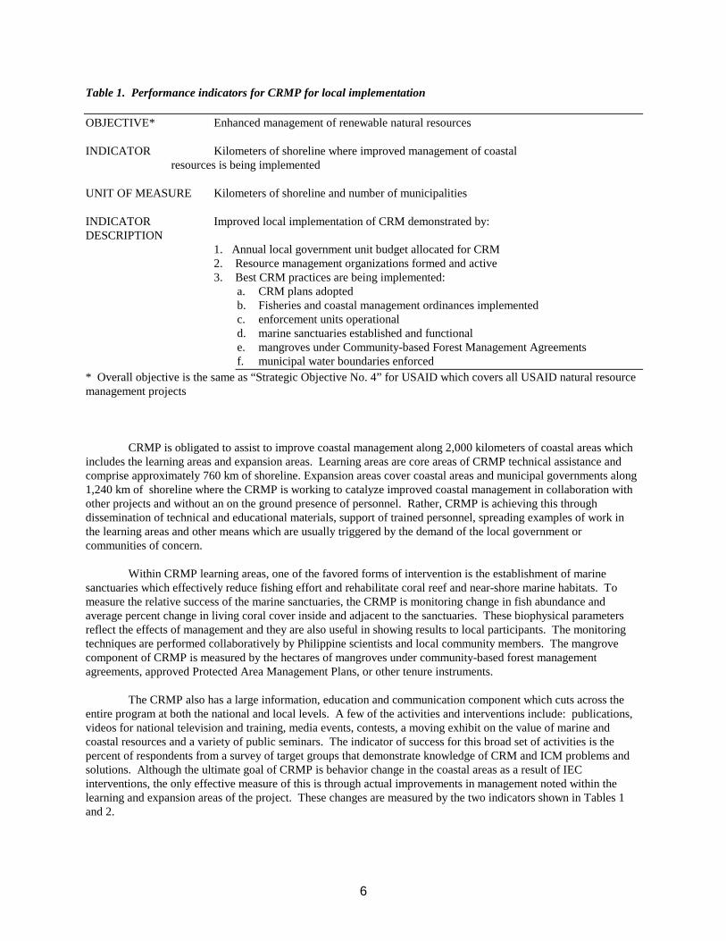
6
Table 1. Performance indicators for CRMP for local implementation
OBJECTIVE* Enhanced management of renewable natural resources
INDICATOR Kilometers of shoreline where improved management of coastalresources is being implemented
UNIT OF MEASURE Kilometers of shoreline and number of municipalities
INDICATOR Improved local implementation of CRM demonstrated by:DESCRIPTION
1. Annual local government unit budget allocated for CRM2. Resource management organizations formed and active3. Best CRM practices are being implemented:
a. CRM plans adoptedb. Fisheries and coastal management ordinances implementedc. enforcement units operationald. marine sanctuaries established and functionale. mangroves under Community-based Forest Management Agreementsf. municipal water boundaries enforced
* Overall objective is the same as “Strategic Objective No. 4” for USAID which covers all USAID natural resourcemanagement projects
CRMP is obligated to assist to improve coastal management along 2,000 kilometers of coastal areas whichincludes the learning areas and expansion areas. Learning areas are core areas of CRMP technical assistance andcomprise approximately 760 km of shoreline. Expansion areas cover coastal areas and municipal governments along1,240 km of shoreline where the CRMP is working to catalyze improved coastal management in collaboration withother projects and without an on the ground presence of personnel. Rather, CRMP is achieving this throughdissemination of technical and educational materials, support of trained personnel, spreading examples of work inthe learning areas and other means which are usually triggered by the demand of the local government orcommunities of concern.
Within CRMP learning areas, one of the favored forms of intervention is the establishment of marinesanctuaries which effectively reduce fishing effort and rehabilitate coral reef and near-shore marine habitats. Tomeasure the relative success of the marine sanctuaries, the CRMP is monitoring change in fish abundance andaverage percent change in living coral cover inside and adjacent to the sanctuaries. These biophysical parametersreflect the effects of management and they are also useful in showing results to local participants. The monitoringtechniques are performed collaboratively by Philippine scientists and local community members. The mangrovecomponent of CRMP is measured by the hectares of mangroves under community-based forest managementagreements, approved Protected Area Management Plans, or other tenure instruments.
The CRMP also has a large information, education and communication component which cuts across theentire program at both the national and local levels. A few of the activities and interventions include: publications,videos for national television and training, media events, contests, a moving exhibit on the value of marine andcoastal resources and a variety of public seminars. The indicator of success for this broad set of activities is thepercent of respondents from a survey of target groups that demonstrate knowledge of CRM and ICM problems andsolutions. Although the ultimate goal of CRMP is behavior change in the coastal areas as a result of IECinterventions, the only effective measure of this is through actual improvements in management noted within thelearning and expansion areas of the project. These changes are measured by the two indicators shown in Tables 1and 2.
7
THE CRMP EXPERIENCE
The CRMP has undertaken many activities during its first two years of operation. Those activities andresults which are directly leading to improved coastal management within the coastal target areas of the projectinclude:
National policy related activities supporting coastal management
1. Legal and jurisdictional guidebook published and distributed
2. Mangrove management policies reviewed and revised to accommodate limited harvesting within managementareas
3. National fisheries code analyzed and publicized for effective implementation by local governments andcommunities
4. National ICM awards among local governments undertaken
5. Several major workshops for national policy makers, judges and prosecutors with responsibility for lawenforcement in coastal areas
6. National coastal master plan initiated
7. Set of booklets initiated on procedures for ICM in the country
8. Numerous publications and videos disseminated throughout the country to interested parties
9. A major exhibit on marine life and the important coastal and ocean habitats is touring the country to fivelocations and has been viewed by more than one million people
Field level activities in six learning areas
1. Memorandums of agreement signed with all 29 municipal governments
2. Participatory coastal resource assessments completed in each of 29 municipal areas covering 129 out of 274barangays
3. Six coastal environmental profiles in final draft form
4. 150 graduates from 11-day ICM course active in learning area ICM projects
5. 152 barangay (community) level management groups formed and active
6. Various municipal ordinances drafted and passed by local governments which enhance coastal fishery andecosystem management
7. One or more marine sanctuaries initiated or established in each learning area
8. 3000 hectares of mangrove habitat in Bohol Province initiated for community stewardship managementagreements in 1999
9. Community level enterprise projects in seaweed farming started in 5 learning areas, with ecotourism as a themewith projects in two learning areas
8
Expansion area activities
1. Ten municipal governments outside of the learning areas have started their own ICM program with informationand encouragement from CRMP
2. Two biodiversity-rich areas are progressing with marine park and area management plans in collaboration withother donors and the national and local government
3. Linkages have been formed with three major donor and government projects to collaborate in up to 50municipalities using the CRMP products listed above
LESSONS BEING LEARNED BY CRMP FOR ICM IN THE PHILIPPINES
An important change in the manner that CRMP approaches the problems of ICM in the Philippines frompast projects is that it is not only rooted in coastal fishing and resource user communities. The CRMP was designedfrom the outset with the realization that the issues facing Philippine coasts and their human communities are toocomplex and caused by too many factors to come to viable solutions by intervening only at the local communitylevel. The CRMP is strategically orchestrating interventions at both the national and local levels with variousgovernment and non-government institutions. It is attempting to catalyze action at the local community level throughcollaboration with local government in a manner which will empower the local government and its partners tocontinue on alone without the assistance of the CRMP. Although the CRMP is less than 3 years in operation, thereare some useful lessons being learned.
1. FOCUS BOTH ON NATIONAL AND LOCAL LEVEL WORK SIMULTANEOUSLY. Past CRM precursorseither focused on national level setups or were too site-specific and/or community based. CRMP workssynergistically and simultaneously at both levels. Thus, the practicality of field experience fuse with thegeneralities espoused at the national level. The processes related to the preparation of the Legal andJurisdictional Guidebook for Coastal Resource Management in the Philippines (DENR, DA-BFAR, DILG,1997) show this synergy. At the field level, problems pertaining to clarification, interpretation andimplementation of laws affecting coastal resource use were identified through research and a series of technicalworking group meetings involving Department of Environment and Natural Resources, Department ofAgriculture-Bureau of Fisheries and Aquatic Resources, Department of Interior and Local Government, and ahost of non-governmental organizations, as well as the academic and scientific communities. These meetingsprovided a venue for the agencies to come to a common interpretation on a number of coastal environmentallaws which are often perceived and treated differently.
2. USE MULTIPLE EDUCATION AND COMMUNICATION STRATEGIES TO BUILD A WIDE BASE OFSUPPORT FOR ICM. CRMP promotes ICM and its related issues to capture the interest of the mass of Filipinopopulation by embarking on media and education campaigns that are designed to increase awareness andultimately, mobilize the populace into action. The approach builds and enhances networks of constituencygroups to support ICM initiatives thus ensuring sustainability beyond the life of the project.
3. ENCOURAGE COLLABORATION AND SYNERGY AMONG AGENCIES AND DONOR PROJECTS.CRMP started its policy component with (1) the development and application of legal and operational guidelinesfor CRM implementation; (2) setting CRM on the national social agenda; and (3) aligning resources and fundingtoward common objectives in consultation with counterpart government agencies and other donors. Theseefforts have resulted in most donors and government sponsored coastal projects at least attempting to coordinateand share plans before implementation starts. This has resulted in more effective field results in severalinstances.
9
4. PROMOTE EXPANSION BY SUPPORTING DEMAND FROM COMMITTED LOCAL GOVERNMENTSAND OTHER INSITUTIONS. CRMP is establishing a critical threshold of coastal municipalities who areactively implementing ICM to achieve the “snowballing” effect. At present, technical assistance at both nationaland local levels targets 2,000 km of shoreline or roughly 11% of national shoreline length. At this thresholdlevel, ICM is anticipated to continue beyond project life because of the development, implementation andinstitutionalization of ICM tools.
5. SUPPORT LEADERSHIP IN ICM THROUGH TRAINING, EDUCATION AND LEARNING BY DOING.The CRMP is nurturing and developing a group of ICM leaders by providing skills and training opportunities atthe local field level as well as provincial and national through training opportunities which emphasize hands-onplanning and analysis within the context of the participants own geographical areas of responsibility.
These lessons are helping to draw up plans for present and future directions for ICM in the Philippines.The most important finding is that for ICM to be adopted by local governments throughout the country in a modewhich enhances both quality of environment and life for people in coastal areas, it must be acceptable,understandable and mostly practical for local governments, communities, national government and private sectorpartners to implement. ICM cannot be empty concepts and ideas. It has to offer tangible solutions which produceresults in terms of improved quality of coastal ecosystems and their production, improved livelihood opportunitiesand improved ability of the part of local and national participants to do the job themselves. Although thecomplexities are great, the vision cannot be clouded by objectives which overshoot their mark. Objectives of fieldprojects must be achievable while providing real benefits.
ACKNOWLEDGMENTS
The CRMP is an initiative of the Government of the Philippines that began in March 1996 and is supported bythe United States Agency for International Development. CRMP is implemented by the Department of Environmentand Natural Resources in partnership with the Department of Agriculture-Bureau of Fisheries and AquaticResources, local government units, non-government organizations and other assisting organizations. Technicalsupport and management are provided by Tetra Tech EM Inc. Useful comments in the preparation of this paper havecome from Abbie Cruz-Trinidad, Policy Advisor to CRMP; Tom Bayer, Training Coordinator for CRMP; JenniferMurphy, Research Intern for CRMP and many others who work directly with the project who are too numerous tomention.
REFERENCES
Christie, P. and A.T. White. 1997. Trends in development of coastal area management in tropical countries: fromcentral to community orientation. Coastal Management 25:155-181.
Chua, T.E. and L.F. Scura (Eds.) 1992. Integrative framework and methods for coastal area management. ICLARMConference Proceedings 37.
Department of Environment and Natural Resources (DENR), Department of Interior and Local Government (DILG),Department of Agriculture - Bureau of Fisheries and Aquatic Resources (DA-BFAR) and Coastal ResourceManagement Project (CRMP). 1997. Legal and Jurisdictional Guidebook for Coastal Resource Managementin the Philippines. Coastal Resource Management Project, Manila, Philippines. 196 p.
Ferrer, E., L. Polotan-de la Cruz and M. Agoncillo-Domingo (eds.) 1996. Seeds of Hope: A Collection of CaseStudies on Community-Based Coastal Resources Management in the Philippines. College of Social Work andCommunity Development, University of the Philippines, Diliman, Quezon City.
10
Gomez, E.D., P.M. Alinio, H.T. Yap and W. Y. Licuanan 1994. A Review of the Status of Philippine Reefs.Marine Pollution Bulletin, Vol 29 (1-3): 62-68.
Kouzes, J.M. and B.Z. Posner. 1995. The Leadership Challenge. Jossey-Bass Publishers: California, USA. 134 p.
Olsen R. De Leon and A. T. White 1997. Mangrove Resource Decline in the Philippines: Government andCommunity Look for New Solutions. Intercoast Network, March, pp. 4-5, University of Rhode Island.
Scura, L.G. 1994. Typological Framework and Strategy Elements for Integrated Coastal Fisheries Management.Food and Agriculture Organization of the United Nations, Rome, 23 p.
Tobin, R. J. and A.T. White. 1992. A Southeast Asian Perspective on Sustainable Development. InternationalEnvironmental Affairs, 4: 50-66.
Walters, J.S., J.Maragos, S. Siar and A.T. White. 1998. Participatory Coastal Resource Assessment: A Handbookfor Community Workers and Coastal Resource Management. Coastal Resource Management Project andSilliman University, Cebu City, Philippines, 113 p.
White, A.T. 1996. Integrated Coastal Management: Lessons to Build On. Tambuli, No. 1, pp. 18-23.
White, A. T. 1997. Planning for Integrated Coastal Management: What are the Steps? Tambuli, No. 3, pp. 15-19.
White, A.T. and N. Lopez. 1991. Coastal Resources Management Planning and Implementation for the FisherySector Program of the Philippines. Proceedings of the 7th Symposium on Coastal and Ocean Management, 8-12 July, Long Beach, pp. 762-775.
White, A.T., L.Z. Hale, Y. Renard and L. Cortesi (eds.) 1994. Collaborative and Community-Based Management ofCoral Reefs, Lessons from Experience, Kumarian Press, Hartford.
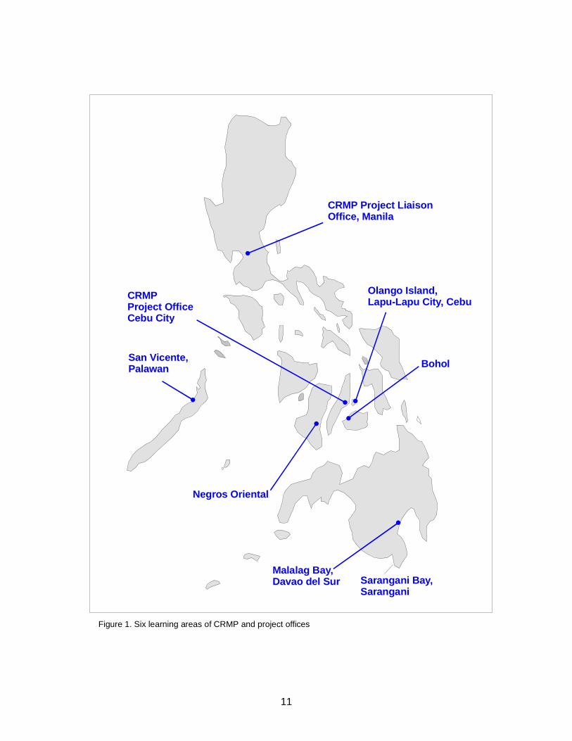
11
CRMP Project LiaisonOffice, Manila
Olango Island,Lapu-Lapu City, CebuCRMP
Project OfficeCebu City
San Vicente,Palawan
Negros Oriental
Sarangani Bay,Sarangani
Malalag Bay,Davao del Sur
Bohol
Figure 1. Six learning areas of CRMP and project offices
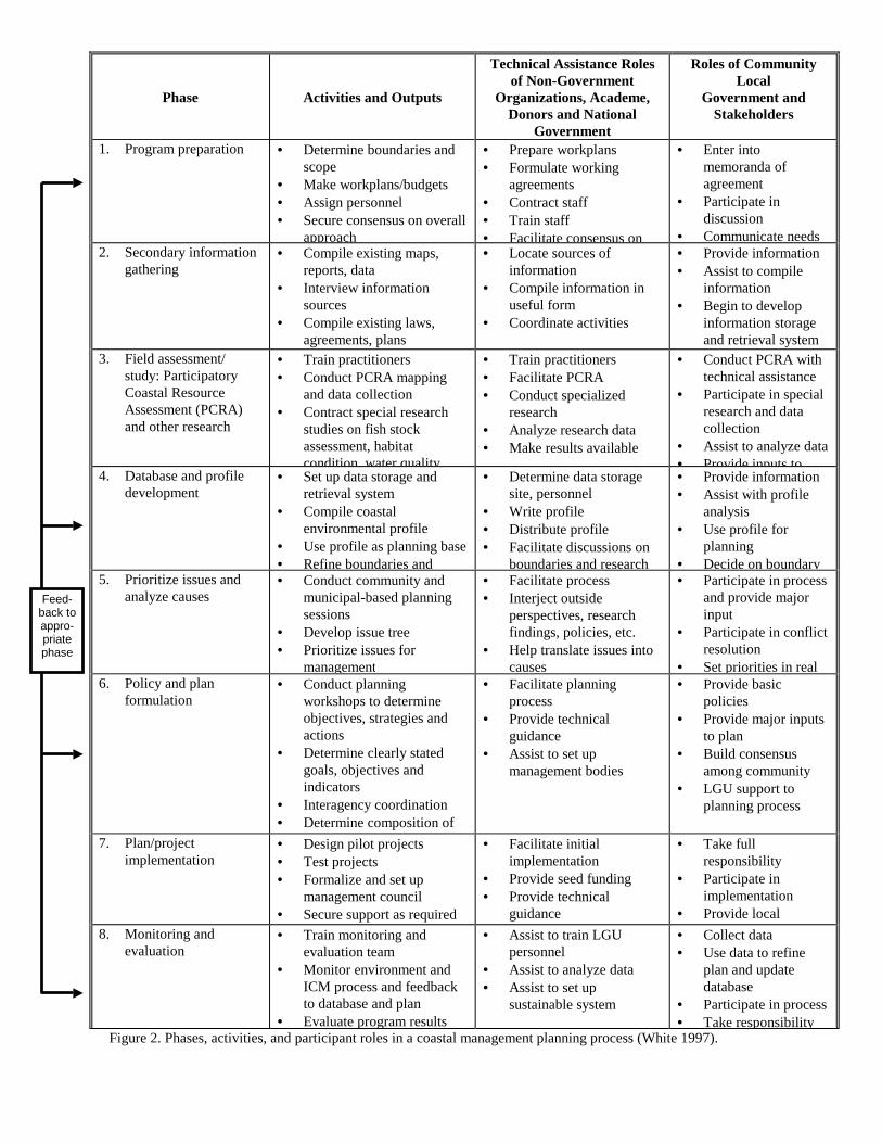
Phase Activities and Outputs
Technical Assistance Rolesof Non-Government
Organizations, Academe,Donors and National
Government
Roles of CommunityLocal
Government andStakeholders
1. Program preparation • Determine boundaries andscope
• Make workplans/budgets• Assign personnel• Secure consensus on overall
approach
• Prepare workplans• Formulate working
agreements• Contract staff• Train staff• Facilitate consensus on
• Enter intomemoranda ofagreement
• Participate indiscussion
• Communicate needs2. Secondary information
gathering• Compile existing maps,
reports, data• Interview information
sources• Compile existing laws,
agreements, plans
• Locate sources ofinformation
• Compile information inuseful form
• Coordinate activities
• Provide information• Assist to compile
information• Begin to develop
information storageand retrieval system
3. Field assessment/study: ParticipatoryCoastal ResourceAssessment (PCRA)and other research
• Train practitioners• Conduct PCRA mapping
and data collection• Contract special research
studies on fish stockassessment, habitatcondition water quality
• Train practitioners• Facilitate PCRA• Conduct specialized
research• Analyze research data• Make results available
• Conduct PCRA withtechnical assistance
• Participate in specialresearch and datacollection
• Assist to analyze data• Provide inputs to
4. Database and profiledevelopment
• Set up data storage andretrieval system
• Compile coastalenvironmental profile
• Use profile as planning base• Refine boundaries and
• Determine data storagesite, personnel
• Write profile• Distribute profile• Facilitate discussions on
boundaries and research
• Provide information• Assist with profile
analysis• Use profile for
planning• Decide on boundary
5. Prioritize issues andanalyze causes
• Conduct community andmunicipal-based planningsessions
• Develop issue tree• Prioritize issues for
management
• Facilitate process• Interject outside
perspectives, researchfindings, policies, etc.
• Help translate issues intocauses
• Participate in processand provide majorinput
• Participate in conflictresolution
• Set priorities in real6. Policy and plan
formulation• Conduct planning
workshops to determineobjectives, strategies andactions
• Determine clearly statedgoals, objectives andindicators
• Interagency coordination• Determine composition of
• Facilitate planningprocess
• Provide technicalguidance
• Assist to set upmanagement bodies
• Provide basicpolicies
• Provide major inputsto plan
• Build consensusamong community
• LGU support toplanning process
7. Plan/projectimplementation
• Design pilot projects• Test projects• Formalize and set up
management council• Secure support as required
• Facilitate initialimplementation
• Provide seed funding• Provide technical
guidance
• Take fullresponsibility
• Participate inimplementation
• Provide local8. Monitoring and
evaluation• Train monitoring and
evaluation team• Monitor environment and
ICM process and feedbackto database and plan
• Evaluate program results
• Assist to train LGUpersonnel
• Assist to analyze data• Assist to set up
sustainable system
• Collect data• Use data to refine
plan and updatedatabase
• Participate in process• Take responsibility
Figure 2. Phases, activities, and participant roles in a coastal management planning process (White 1997).
Feed-back toappro-priatephase